Related Research Articles
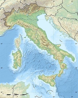
The geography of Italy includes the description of all the physical geographical elements of Italy. Italy, whose territory largely coincides with the homonymous geographical region, is located in southern Europe and comprises the long, boot-shaped Italian Peninsula crossed by the Apennines, the southern side of Alps, the large plain of the Po Valley and some islands including Sicily and Sardinia. Italy is part of the Northern Hemisphere. Two of the Pelagie Islands are located on the African continent.
Lithuania is one of the countries in the Baltic region of Europe. The most populous of the Baltic states, Lithuania has 262 km (163 mi) of coastline consisting of the continental coast and the "Curonian Spit" coast. Lithuania's major warm-water port of Klaipėda lies at the narrow mouth of Curonian Lagoon, a shallow lagoon extending south to Kaliningrad and separated from the Baltic sea by Curonian Spit, where Kuršių Nerija National Park was established for its remarkable sand dunes.

Neman, Nemunas or Niemen is a river in Europe that rises in central Belarus and flows through Lithuania then forms the northern border of Kaliningrad Oblast, Russia's western exclave, which specifically follows its southern channel. It drains into the Curonian Lagoon, narrowly connected to the Baltic Sea. The 937 km (582 mi) long Neman is a major Eastern European river. It flows generally west to Grodno within 12 kilometres (7.5 mi) of the Polish border, north to Kaunas, then westward again to the sea.

Klaipėda County is one of ten counties in Lithuania, bordering Tauragė County to the southeast, Telšiai County to the northeast, Kurzeme in Latvia to the north, and Kaliningrad Oblast in Russia to the south. To the west is the Baltic Sea. It lies in the west of the country and is the only county to have a coastline and not be landlocked. Its capital is Klaipėda. On 1 July 2010, the county administration was abolished, and since that date, Klaipėda County remains as the territorial and statistical unit.

Grenadines is an administrative parish of Saint Vincent and the Grenadines, comprising the islands of the Grenadines other than those belonging to Grenada. The capital is Port Elizabeth. It's the only parish in the country that's not located on the main island.

Ventė Cape, sometimes referred to as Ventė Horn or Ventė Peninsula, is a peninsula in the Nemunas Delta, in Šilutė district, Lithuania. It is known as a resting place for birds during their migration, particularly in autumn. Ventė Cape Ornithological Station – one of the first bird ringing stations in Europe still in operation – was opened here by Tadas Ivanauskas in 1929.
Scalovia or Skalvia was the area of Prussia originally inhabited by the now extinct Baltic tribe of Skalvians or Scalovians which according to the Chronicon terrae Prussiae of Peter of Dusburg lived to the south of the Curonians, by the lower Nemunas river, in the times around 1240.

Nemunas Delta is the Lithuanian name for the Neman (Nemunas) River Delta, in Lithuania. Prior to post-World War II border changes, it was known in German as the Memel Niederung, as the Neman was for centuries called the Memel in German.

Klaipėda Castle, also known as Memelburg or Memel Castle, is an archeological site and museum housed in a castle built by the Teutonic Knights in Klaipėda, Lithuania, near the Baltic Sea. The Teutons called the castle Memelburg or Memel, and Klaipėda was generally known as Memel until 1923, when Lithuanian military forces took over the city. The castle was first mentioned in written sources in 1252, and underwent numerous destructions and reconstructions in the centuries that followed. During the 19th century, having lost its strategic importance, the castle was demolished. Archeological work was performed at the site during the 20th century, and in 2002 a museum was established underneath one of its bastions. The museum has reopened following restoration, which was completed in 2021.
Nemunas Delta Regional Park, established in 1994, is located in Lithuania within the Nemunas Delta where the Nemunas flows into the Baltic Sea. The park covers 29,013 ha.
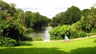
Copenhagen is a green city well endowed with open spaces. It has an extensive and well-distributed system of parks that act as venues for a wide array of events and urban life. As a supplement to the regular parks, there are a number of congenial public gardens and some cemeteries doubling as parks. It is official municipal policy in Copenhagen that all citizens by 2015 must be able to reach a park or beach on foot in less than 15 minutes.

The Port of Nida is a port in the city of Nida, Lithuania. It is located on the Curonian Lagoon side of the Curonian Spit. It is mostly used for ferries, connection with inland Lithuania and fishing.

Kiaulės Nugara is an island in the Curonian Lagoon, Port of Klaipėda, Lithuania. The name of island means the back of a pig in the Lithuanian language.
References
- ↑ "Islands of Lithuania". GeoNames . Retrieved October 25, 2021.
| History |
|  | ||||||||
|---|---|---|---|---|---|---|---|---|---|---|
| Geography | ||||||||||
| Politics |
| |||||||||
| Economy | ||||||||||
| Society |
| |||||||||
| Sovereign states |
| |
|---|---|---|
| States with limited recognition | ||
| Dependencies and other entities | ||