
Albania is a country in southeastern Europe that lies along the Adriatic and Ionian Seas, with a coastline spanning approximately 476 km (296 mi). Situated on the Balkan Peninsula, it is one of the most mountainous countries in Europe. It is bounded by Montenegro to the northwest, Kosovo to the northeast, North Macedonia to the east and Greece to the southeast and south.

A marine park is a designated park consisting of an area of sea set aside to achieve ecological sustainability, promote marine awareness and understanding, enable marine recreational activities, and provide benefits for Indigenous peoples and coastal communities. Most marine parks are managed by national governments, and organized like 'watery' national parks, whereas marine protected areas and marine reserves are often managed by a subnational entity or non-governmental organization, such as a conservation authority.

Tourism in Albania has been a key element to the country's economic activity and is constantly developing. Albania is characterized by its rich archaeological and cultural heritage dating back to the classical period when Illyrians and Ancient Greeks inhabited the region. Over the course of history, the territory of Albania was occupied and populated by Romans, Byzantines, Venetians and Ottomans. Notably the country features unspoiled beaches, mountainous landscapes, traditional cuisine, archaeological artifacts, unique traditions, low prices and the wild atmosphere of the countryside.

Sazan is an Albanian uninhabited island in the Mediterranean Sea. The largest of Albania's islands, it is a designated military exclusion zone; it lies in a strategically important location between the Strait of Otranto and the mouth of the Bay of Vlorë, marking the border between the Adriatic and Ionian seas.

Vlorë County is one of the 12 counties of Albania with the city of Vlorë being the county capital. The county spans 2,706 square kilometres (1,045 sq mi) and has a total population of 146,681 people as of 2023. It borders the counties of Fier and Gjirokastër, as well as the Adriatic and Ionian Sea. Greece borders Vlorë to the south.
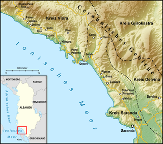
The Albanian Riviera, also popularly known as Bregu, is a coastline along the north-eastern Ionian Sea in the Mediterranean Sea, encompassing the districts of Sarandë and Vlorë in south-western Albania. It forms an important section of the Albanian Ionian Sea Coast, dotted with the villages of Palasë, Dhërmi, Vuno, Himara, Qeparo, Borsh, Piqeras, Lukovë, and the city of Sarandë.
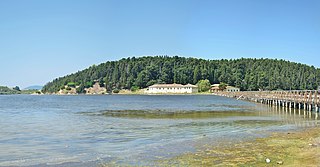
Narta Lagoon is a lagoon of the Adriatic Sea on the Mediterranean Sea in the central coast of Albania. The lagoon extends north of the Bay of Vlorë on the eastern shore of the Strait of Otranto and is separated from the sea by a narrow littoral strip, consisting of an alluvial dune. It has a surface area of 41.8 km2 (16.1 sq mi) with a maximal depth of 1.5 m (4.9 ft).

Agriculture in Albania is still a significant sector of the economy of Albania, which contributes to 22.5% of the country's GDP. The country spans 28,748 square kilometres of which 24% is agricultural land, 36% forest land, 15% pasture and meadow and 25% urban areas including lakes, waterways, unused rocky and mountain land. It can be separated into three main zones such as the lowland zone alongside the coastline of the country, the hill zone in the lowland and the mountain zone.

The environment of Albania is characterised by unique flora and fauna and a variety of landforms contained within a small nation. It also consists of different ecoregions, which represent the natural geographical ecosystem, water systems, weather, renewable resources and influences upon them.

Llogara National Park is a national park centered on the Ceraunian Mountains along the Albanian Riviera in southwestern Albania, spanning a surface area of 1,769 ha (17.69 km2). The park's terrain includes large alpine meadows, vertical rock faces, precipices and dense forests. Most area of the park is covered by forests and was established in 1966 to protect several ecosystems and biodiversity of national importance. The International Union for Conservation of Nature (IUCN) has listed the park as Category II. The region has been recognised as an important Bird and Plant Area, supporting significant number of species.

The Bay of Vlorë is a large bay of the Adriatic Sea situated along the Albanian Adriatic Sea Coast on the Mediterranean Sea in Southern Europe. It opens to the sea in the northwest and is largely surrounded by the lagoon of Narta in the north, the city of Vlorë in the northeast, the mountains of the Ceraunians in the east and southeast, and the peninsula of Karaburun in the southwest and west.
The Karaburun Peninsula, also known as Cape Linguetta, is a peninsula of the Mediterranean Sea located in Southern and Southeastern Europe, which is almost completely surrounded by both the Adriatic Sea to the north and the Ionian Sea to the south. It is located in Southwestern Albania along the Albanian Ionian Sea Coast, whereas the Strait of Otranto separates it from Italy. The Strait of Mezokanal separates the peninsula from Sazan Island, while in the southeast stretches the Bay of Vlorë. In classical antiquity, its name was the "Akrokeraunian Peninsula", whose name was derived from the eponymous Akrokeraunian mountains; this is because, in terms of geology, the Rrëza e Kanalit on the peninsula represent the continuation of said mountains, which are the highest and most extensive mountain range system that extends parallel to the Ionian Sea. Karaburun peninsula is sometimes called Ceraunian Peninsula due to the name of the mountain range. Formed during the mesozoic era of the cretaceous and paleogene period, the crests of the mountain range form a northwest-southeast line with a series of distinct peaks along its irregular structure that are broken apart by steep and unequally slopes. The highest peaks are namely, the Maja Çaderës, Maja e Flamurit, Maja e Koretës and Maja e Ilqes.

Despite being a relatively small country, Albania is exceedingly rich in biodiversity. Its ecosystems and habitats support over 5,550 species of vascular and non-vascular plants and more than 15,600 species of coniferous and non-coniferous evergreens, most of which are threatened at global and European levels. The country has made recent efforts to expand its network of protected areas which now include: 11 national parks, 1 marine park, 718 nature monuments, 23 managed nature reserves, 11 protected landscapes, 4 World Heritage Sites, 4 Ramsar sites and other protected areas of various categories, that when combined, account for 21.36% of the territory. Furthermore, a biosphere reserve, 45 important plant areas and 16 important bird areas are found in the country.

Karaburun-Sazan Marine Park is a marine park in the Vlorë County of southwestern Albania. The marine park encompasses over 125.70 km2 (48.53 sq mi) and comprises the boundaries of both the Peninsula of Karaburun and the Island of Sazan. It is home to a vast array of landforms, including mountains, caves, islands, depressions, bays, cliffs, canyons and rocky coasts, all contributing to an exceptionally considerable biological diversity. The marine park has been identified as an Important Bird and Plant Area, because it supports immense bird and plant species. Containing ecosystems and habitats that are specific to the Mediterranean Basin, the convention of Barcelona has classified the marine park as a Specially Protected Areas of Mediterranean Importance.

For a small country, Albania is characterised by a considerable wealth of terrestrial and marine ecosystems and habitats with contrasting floral, faunal, and fungal species, defined in an area of 28,748 square kilometres. Most of the country is predominantly of Mediterranean character, comprehending the country's center and south, while the alpine affinity is more visible in the northeast.

Prespa National Park is a national park situated in southeastern Albania on the border triangle shared with Greece and North Macedonia. At approximately 277.5 km2 (107.1 sq mi), the park encompasses the country's sections of the Great and Small Prespa Lake. It is considerably characterised by high mountains, narrow islands, vast freshwater wetlands, salt marshes, meadows, reed beds and dense forests.

The Albanian Adriatic Sea Coast stretches in the south-eastern Adriatic Sea beginning at the Gulf of Drin in the north, across the port cities of Shëngjin, Durrës, and Vlorë, to the Bay of Vlorë in the south, where the Albanian Riviera and the Albanian Ionian Sea Coast begin.
The Albanian Ionian Sea Coast is a coastline of the north-eastern Ionian Sea, that encompasses the south-western border of the Republic of Albania, stretching from the southern half of Karaburun Peninsula, across the historical region of Labëria, the city of Sarandë, the mountains of the Ceraunians, and the Albanian Riviera, to the Lake of Butrint, where the Strait of Corfu separates the country from Greece.

The Cave of Haxhi Ali is a karst cave formed in limestone cliffs in southwestern Albania, located in the Karaburun Peninsula near the Cape of Gjuhëz in Vlorë County. The cave was named after Haxhi Aliu, a prominent Albanian warrior and sailor from Ulcinj who fled with his son in this cave. Several archaeological objects has been found, that prove that this cave was used by traders and passers during the ancient times. The cave has a length of 30 m (98 ft) with a width which can vary between of 10–12 m (33–39 ft) and a height of 18 m (59 ft).

The Bay of Grama is a bay in the Ionian Sea situated along the Albanian Ionian Sea Coast on the Mediterranean Sea in Southern Europe. It is one of many bays of the western Ceraunian Mountains along the Albanian Riviera south of the Karaburun Peninsula. The bay is primarily known as a touristic place, and for the engraved inscriptions in the surrounding coastal cliffs as its name relieves.


