List of islands of Denmark

Last updated

A map showing the Jutland Peninsula and most notable larger islands of Denmark. Denmark islands.PNG
A map showing the Jutland Peninsula and most notable larger islands of Denmark.

This is a list of islands of Denmark, specifically those forming the Danish archipelago just off the European continent.

Contents

Overview

There are around 1400 islands in Denmark, where about 409 of the islands are named, not including the Faroe Islands or Greenland. [1] Some 70 of them are populated while the rest are uninhabited. Some of the uninhabited islands have only become uninhabited in recent decades, for economic reasons, as lighthouses and other publicly run facilities either became automated, or relocated to main islands or Jutland peninsula. Others became uninhabited as living costs outpaced income for the often fewer than 10 locals.

Definition

Different lists of Danish islands vary, depending on how the word "island" is defined. According to the official Danish Government definition, an "island" needs to be surrounded by water at least one-half metre deep, and also to have land vegetation. [2]

Another common criterion is that an "island" needs to be surrounded by free-flowing, natural water and not just an artificial, narrow canal. According to this criterion, places such as Christianshavn and Holmen in Copenhagen, although sometimes referred to as artificial islands, are actually parts of the island of Amager.

Dynamic number

Drejo, Hjorto and Skaro seen from above Ohavet-airphoto.jpg
Drejø, Hjortø and Skarø seen from above

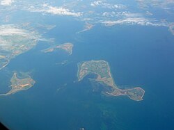
The number of islands in Denmark changes from time to time. New islands are occasionally formed by sedimentation. Several examples of these new islands are found in the waters around Æbelø, north of Funen, including Drætlingen which formed in the late 1990s, and a still unnamed islet that was registered in 2008. These new islands are generally less stable than larger, morainic islands, and may later disappear again. Other islands are created artificially. Peberholm, formed in the process of construction of the Øresund Bridge, is a notable example. Other artificial Danish islands include a number of marine fortresses off Copenhagen, such as Middelgrundsfortet, Trekroner Fort and Flakfortet.

Islands may also disappear. An example of this is Jordsand, one of the Danish Wadden Sea Islands. According to records from 1231, the island then had an area of about 2,000 hectares (8 square miles). After a series of severe storms during that century, its area decreased to around 41 hectares, and by 1763 to around 18 hectares. By December 1999, the European windstorm Cyclone Anatol had destroyed the last piece of the island and Jordsand had ceased to exist. [3]

In other cases, islands are absorbed by larger neighbouring masses of dry land, as a result of either natural sedimentation or artificial land reclamation in the channels separating them. Sometimes this means that an island becomes a cape or headland, or a peninsula as is the case of the former island of Reersø.

Denmark's second largest island, the North Jutlandic Island, was not always an island. A storm on 3 February 1825 penetrated the narrow land mass, Agger Tange, and thus separated Northern Jutland from the rest of Jutland. The area had earlier been an island, when a strait at Vust had been open prior to the 12th century.

List of 100 largest Danish islands

This is a list of the 100 largest islands of Denmark (press the symbol after the headings in the table to rearrange the list according to population size, location or alphabetically):

RankIsland's nameAreaPopulation [4]
(1 January 2013)
Location
km2sq mi
1 Zealand 7,0312,7152,208,348 Baltic Sea / Kattegat / Øresund / Great Belt
2 North Jutlandic Island
(Vendsyssel-Thy)
4,6851,809297 886 North Sea / Kattegat / Skagerrak / Limfjord
3 Funen 2,9851,153456,128 Great Belt / Little Belt / Kattegat / South Funen Archipelago
4 Lolland 1,24348062,578 Baltic Sea / Smålandsfarvandet / Storstrømmen
5 Bornholm 58822740,715 Baltic Sea
6 Falster 51419842,544 Baltic Sea / Storstrømmen
7 Mors 36814221,163 Limfjord
8 Als 32112450,682 Little Belt
9 Langeland 28411012,644 Great Belt
10 Møn 218849,580 Baltic Sea
11 Rømø 12950618 Wadden Sea, North Sea
12 Samsø 112433,806 Kattegat
13 Læsø 101391,839 Kattegat
14 Amager 95.336.8180,657 Øresund
15 Ærø 88346,516 South Funen Archipelago
16 Tåsinge 70276,174 South Funen Archipelago
17 Fanø 56223,237 Wadden Sea, North Sea
18 Fur 228.5826 Limfjorden
19 Anholt 228.5169 Kattegat
20 Fejø 166.2464 Smålandsfarvandet
21 Saltholm 16.06.21 Øresund
22 Orø 155.8846 Isefjorden
23 Endelave 13.15.1176 Kattegat
24 Bogø 13.05.01,108 Storstrømmen
25 Sejerø 12.44.8348 Kattegat
26 Femø 11.04.2123 Smålandsfarvandet
27 Jegindø 7.93.1464 Limfjord
28 Mandø 7.62.941 Wadden Sea, North Sea
29 Thurø 7.52.93,595 South Funen Archipelago
30 Alrø 7.52.9147 Horsens Fjord
31 Agersø 7.02.7181 Great Belt
32 Venø 6.52.5190 Limfjord
33 Bågø 6.22.427 Little Belt
34 Lyø 6.02.3101 South Funen Archipelago
35 Egholm 62.348 Limfjord
36 Avernakø 5.92.3114 South Funen Archipelago
37 Årø 5.72.2157 Little Belt
38 Glænø 5.62.251 Smålandsfarvandet
39 Gavnø 5.52.131 Great Belt
40 Strynø 4.91.9202 South Funen Archipelago
41 Nyord 4.81.941 Baltic Sea
42 Omø 4.51.7154 Great Belt
43 Drejø 4.31.764 South Funen Archipelago
44 Fænø 3.91.52 Little Belt
45 Agerø 3.81.526 Limfjord
46 Tunø 3.51.4109 Kattegat
47 Enø 3.41.3332 Smålandsfarvandet
48 Livø 3.31.39 Limfjord
49 Hjarnø 3.21.2104 Kattegat
50 Askø 2.821.0937 Smålandsfarvandet
51 Æbelø 2.500.97- Kattegat
52 Barsø 2.500.9722 Little Belt
53 Nekselø 2.200.8518 Kattegat (Sejerøbugten)
54 Brandsø 2.000.77- Little Belt
55 Skarø 1.970.7633 South Funen Archipelago
56 Tærø 1.730.671 Storstrømmen
57 Masnedø 1.680.65129 Storstrømmen
58 Vejrø 1.570.615 Storstrømmen
59 Bjørnø 1.500.5832 South Funen Archipelago
60 Sprogø 1.500.58- Great Belt
61 Eskilsø 1.390.546 Roskilde Fjord
62 Dybsø 1.340.521 Smålandsfarvandet
63 Vigelsø 1.320.51- Odense Fjord
64 Siø 1.310.5115 South Funen Archipelago
65 Langø 1.300.502 Storstrømmen
66 Peberholm 1.30.50- Øresund
67 Romsø 1.090.42- Great Belt
68 Skalø 1.060.41- Smålandsfarvandet
69 Enehøje 1.040.40- Nakskov Fjord
70 Langli 1.000.39- Wadden Sea, North Sea
71 Hjortø 0.900.358 South Funen Archipelago
72 Farø 0.930.365 Storstrømmen
73 Birkholm 0.920.3611 South Funen Archipelago
74 Illumø 0.900.35- South Funen Archipelago (Helnæsbugten)
75 Lilleø 0.860.337 Storstrømmen
76 Rågø 0.800.31- Smålandsfarvandet
77 Hesselø 0.710.27- Kattegat
78 Store Egholm 0.700.27- South Funen Archipelago
79 Hjelm 0.630.24- Kattegat
80 Vorsø 0.60.231 Horsens Fjord
81 Halmø 0.500.19- South Funen Archipelago
82 Strynø Kalv 0.500.19- South Funen Archipelago (Helnæsbugten)
83 Fjandø 0.400.15- Nissum Fjord
84 Vejlø 0.370.14- Nakskov Fjord
85 Mejlø 0.340.13- Kattegat / Great Belt
86 Draget 0.280.11- Kattegat (off Bogense)
87 Store Svelmø 0.270.10- South Funen Archipelago
88 Christiansø 0.250.09792 Baltic Sea
89 Kalvø, Guldborgsund 0.220.085- Baltic Sea (Guldborgsund)
90 Slotsholmen 0.210.08114 Øresund
91 Tornø 0.210.0814 Odense Fjord
92 Græsholm, Hirsholmene 0.210.0813 Kattegat
93 Vigø 0.200.077- South Funen Archipelago (Helnæsbugten)
94 Slotø 0.200.077- Nakskov Fjord
95 Hjælmshoved 0.200.077- South Funen Archipelago
96 Kalvø, Genner Bugt 0.170.06613 Little Belt
97 Hirsholm 0.170.0663 Kattegat
98 Ejlinge 0.160.062- Kattegat
99 Møgelø 0.140.054- Julsø

Other populated islands

Areas sometimes referred to as islands

Other small unpopulated islands

See also

References

  1. "Facts and Figures Archived 2010-06-30 at the Wayback Machine ", Danish Defence, Defence Command Denmark. Retrieved 11 June 2010.
  2. "Hov - den der ø har jeg ikke set før". Politiken. Retrieved 2010-07-30.
  3. . "Danmarksnationalparker.dk". Øer der kom og gik. Archived 2013-06-24 at archive.today Retrieved 20 June 2013
  4. "Danmarks Statistik." Retrieved 11 June 2010.
  5. "Lindholm Forsøgsstation" Archived 2011-07-19 at the Wayback Machine , Møn Kulturarvsatlas. (in Danish) 13 June 2010.