Agger Tange

Last updated
Agger Tange Agger in Denmark - Agger Tange (22).jpg
Agger Tange

Agger Tange ("tange" is Danish for "isthmus" or "panhandle") is a peninsula located between the Limfjord and the North Sea. Agger Tange protrudes from the North Jutlandic Island, immediately south of the village Agger in Thy.

Contents

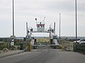
As the name implies, Agger Tange was originally an isthmus, but North Sea storms breached the tombolo in the 1800s, creating two peninsulas, north and south. The north peninsula retained the name Agger Tange, although it was no longer an isthmus. The south peninsula became known as Harboøre Tange. The two peninsulas are separated by the Thyborøn Channel, facilitating ship traffic through the Limfjord canal.

History

Agger Tange at the western border of the Limfjord as it appeared around 1900. The previous extent is shown by dotted lines. Nissumbredningmm.jpg
Agger Tange at the western border of the Limfjord as it appeared around 1900. The previous extent is shown by dotted lines.

The sand tombolo of Agger Tange was created around 1100 AD, as a result of natural siltation. [1]

The North Sea coast is often windy and fierce, and Agger Tange has experienced many smaller floods during storms. In 1825, a severe storm breached and created what became known as the Agger Channel (in Danish: Agger Kanal or Aggerkanalen), effectually merging the North Sea with the brackish Limfjord permanently. The channel gradually widened, but closed up again during the 1850s, again due to natural siltation. [1] A similar breach occurred during a storm in 1862 at the nearby town of Thyborøn, south of Agger. This breach became known as the Thyborøn Channel, and to stop further erosion, both the Thyborøn Channel and the entire Agger Tange has later been fortified with coastal protection. [2] [3] The southern part of the breached tombolo, across the Thyborøn Channel, is known as Harboøre Tange, referring to the railroad town of Harboøre at the south base of the peninsula. [4]

The flooding event in 1825, separated the northernmost part of Jutland from the mainland, thus creating the North Jutlandic Island. The breach made it possible to sail from the North Sea to the Kattegat, shortcutting the Skagerrak Sea, and the Agger Channel and Thyborøn Channel soon became important for international traffic. In 1875, the Thyborøn Channel was secured and improved to serve seafaring traffic better. [3]

In World War II, during the German occupation of Denmark, Agger Tange became part of the Atlantic Wall with several bunker fortifications.

Nature

Designations
Official nameNissum Bredning with Harboore and Agger Tange
Designated9 February 1977
Reference no.144 [5]

The Danish State owns 2,400 ha on Agger Tange and Harboøre Tange that was made a protected area in 1984. [6] Agger Tange is part of Natura 2000-Area 28 with Nissum Bredning, Skibsted Fjord, and Agerø. [7] It is a Ramsar wetland, Special Area of Conservation, and Special Protection Area.

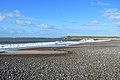
The beach meadows on Agger Tange are home to many species of birds, both domestic and migrating birds. As most of them are nesting on the ground, the meadows are not accessible in the spring and early summer, from 1 April to 15 July. The wetlands, however, are not to be disturbed at any time of year. [8]

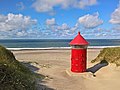
Agger Tange constitutes the southernmost part of Thy National Park, and is sometimes referred to as "the main gate" of the national park. Close to the harbor at the southern tip of the peninsula, is an unmanned information house called Svanholmhus with various facilities in connection to the national park. [9]

See also

Related Research Articles

<span class="mw-page-title-main">Aalborg Municipality</span> Municipality in Nordjylland region of Denmark

Aalborg Municipality is a municipality in North Jutland Region on the Jutland peninsula in northern Denmark. The municipality straddles the Limfjord, the waterway which connects the North Sea and the Kattegat east-to-west, and which separates the main body of the Jutland peninsula from the island of Vendsyssel-Thy north-to-south. It has a land area of 1,143.99 km2 (441.70 sq mi) and a population of 222,571.

<span class="mw-page-title-main">Løgstør</span> Town in Region Nordjylland, Denmark

Løgstør is a town in Denmark with a population of 3,972 It is located 47 km west of Aalborg and 64 km north of Viborg. Løgstør's city centre consists of old streets with small houses built in the 1800s for fishermen and sailors. One of these houses was donated by Danish housemen to the author and poet Johan Skjoldborg in 1918, who lived in the house until his death. It is located on Johan Skjoldborgs Vej.

<span class="mw-page-title-main">Lemvig Municipality</span> Municipality in Midtjylland, Denmark

Lemvig Municipality is a municipality in Region Midtjylland on the west coast of the Jutland peninsula in west Denmark. The municipality covers an area of 516.63 km2, and has a population of 19,371 (2023). Its mayor is Erik Flyvholm, a member of the Venstre political party.

Until 1 January 2007 Thyborøn-Harboøre was a municipality in the former Ringkjøbing County on the west coast of the Jutland peninsula in west Denmark. The municipality covered an area of 42 km2, and had a total population of 4,690 (2005). Its last mayor was Erik Flyvholm.

<span class="mw-page-title-main">North Jutlandic Island</span> The northernmost part of Denmark and of Jutland

The North Jutlandic Island, Vendsyssel-Thy, or Jutland north of the Limfjord is the northernmost part of Denmark and of Jutland. It is more common to refer to the three traditional districts of Vendsyssel, Hanherred, and Thy. The area has been intermittently a tied island and, during modern times, was not surrounded by water until a storm in February 1825, which severed the region from the remainder of Jutland and caused a water connection between the North Sea and the western end of the Limfjord. Hence, it is traditionally regarded as a part of Jutland rather than a separate island.

<span class="mw-page-title-main">Limfjord</span> Shallow part of the sea, located in Denmark

The Limfjord is a shallow part of the sea, located in Denmark where it has been regarded as a inlet ever since Viking times. However, it now has entries both from the North Sea and Kattegat, and hence separates the North Jutlandic Island from the rest of the Jutland Peninsula. The Limfjord extends from Thyborøn Channel on the North Sea to Hals on the Kattegat. It is approximately 180 kilometres long and of an irregular shape with numerous bays, narrowings, and islands, most notably Mors, and the smaller ones Fur, Venø, Jegindø, Egholm and Livø. It is deepest at Hvalpsund.

<span class="mw-page-title-main">Thisted</span> Town in Nordjylland, Denmark

Thisted is a town in the municipality of Thisted in the North Denmark Region of Denmark. It has a population of 13,534 and is located in Thy, in northwestern Jutland.

<span class="mw-page-title-main">Thyborøn</span> Town in Region Midtjylland, Denmark

Thyborøn is a fishing village in Jutland, Denmark with a population of 1,898, primarily famous for being the site of numerous shipwrecks, such as that of the Imperial Russian naval vessel Alexander Nevsky.

<span class="mw-page-title-main">Thy (district)</span> District in Jutland, Denmark

Thy is a traditional district in northwestern Jutland, Denmark. It is situated north of the Limfjord, facing the North Sea and Skagerrak, and has a population of around 44,000. The capital is Thisted. Snedsted, Hanstholm and Hurup are minor towns in the area.

<span class="mw-page-title-main">Hanherred</span>

Han Herred or Hanherrederne is a traditional district in northern Jutland, Denmark. It lies between Thy in the west and Vendsyssel in the east. To the north it faces the North Sea (Skagerrak) and to the south the Limfjord. There are only two towns with more than 1,000 inhabitants, Fjerritslev and Brovst.

<span class="mw-page-title-main">Förden and East Jutland Fjorde</span>

The eastern coast of the Jutland Peninsula, consisting of Danish Jutland and German Schleswig-Holstein features a type of narrow bay called Förde in German and fjord in Danish. These bays are of glacial origin, but the glacial mechanics were different from those of Norwegian Fjords and also from those of Swedish and Finnish Fjards. Inlets similar to these are also found on the Door peninsula, Bruce peninsula, and Long island.

<span class="mw-page-title-main">Lemvig</span> Town in Denmark

Lemvig is a market town located on the Limfjord in North Jutland, Denmark. The town has a population of 6,827 (2023)., and is the seat of Lemvig Municipality in the North Jutland Region.

<span class="mw-page-title-main">Jutland</span> Peninsula in Europe

Jutland is a peninsula of Northern Europe that forms the continental portion of Denmark and part of northern Germany.

Nissum Fjord is an inlet located in West Jutland, west of Vemb and is demarcated from the North Sea by a 1.3 km wide isthmus, Bøvling Klit, and passes through a lock in Thorsminde. The inlet has a water area of 70 km2 or 7,000 ha. but the average water depth is only about 1 meter, and the deepest areas in Felsted Kog and the center of the inlet are between 2 and 3 meters. The northern part of the inlet, called Bøvling Fjord, is so shallow that it is sometimes completely drained by strong winds. Nissum Fjord has several creeks which empty into it, such as Ramme Creek, Flynder Creek, Damhus Creek and the largest creek, Storåen, which has its mouth at the eastern corner of Felsted Kog in the southeastern end of the inlet. Since the 1870s, Thorsminde has regulated the inlet's water level and salinity content at the lock, which facilitates water exchange in the inlet. The whole inlet as well as some surrounding land is designated as a wildlife sanctuary and Ramsar wetland, and the inlet and its surrounding reeds and meadows have a rich variety of bird life.

<span class="mw-page-title-main">February flood of 1825</span> Storm surge flood on the North Sea coast of Germany and the Netherlands

The February flood of 1825, also known in Germany as the Great Hallig Flood, was a devastating flood that occurred from 3 to 5 February 1825 on the North Sea coast in which about 800 people were drowned.

<span class="mw-page-title-main">Thy National Park</span>

Thy National Park is a national park area in Thy, Denmark, opened to the public on 22 August 2008. It is located in Northwest Jutland, along the coast from Hanstholm to Agger Tange and it spans 55 km (34 mi) north to south and 5–12 km (3.1–7.5 mi) east to west. The total area of the national park is 244 km2.

Langerak is the name for the eastern part of Limfjord in Denmark and is one of the East Jutish Fjorde. The designation covers the narrow length of the fjord between Aalborg and Hals which is approximately 30 km long and ranges between 400m to 2 km in width. The meandering fjord was created during the last ice age.

<span class="mw-page-title-main">Nissum Bredning</span>

Nissum Bredning is the westernmost bredning in the Limfjord situated between Thyborøn Channel, through which the fjord is connected to the North Sea, and Oddesund with Oddesund Bridge. Its size is around 200 km2 and the depth is up to 6 meters. The length from east to west is about 24 km, and from south Gjeller Odde to the north Røjensø Odde is about 10 kilometer; from here it continues as Krik Vig to the north. To the west, at Thyborøn and Harboøre Tange, there are some sandbanks, Fjordgrund and Gåseholm. There is a navigable channel Sælhundeholm Løb, going south from the channel along Agger Tange, passing Rønland with the chemical factory Cheminova, where it turns east.

References

  1. 1 2 Danmarks Lodsmuseumsforening. "Aggerkanalen" [The Agger Channel](PDF) (in Danish). Museum Amager. Retrieved 13 June 2020.
  2. "Historie - Agger Tange og Flade Sø" [History - Agger Tange and Flade Sø] (in Danish). The Danish Nature Agency. Retrieved 13 June 2020.
  3. 1 2 Bo Poulsen (22 August 2019). "Stormfloden i 1825, Thyborøn Kanal og kystsikring" [The flood in 1825, Thyborøn Channel and coastal protection]. danmarkshistorien.dk (in Danish). Aarhus University. Retrieved 13 June 2020.
  4. "Historie - Harboøre Tange" (in Danish). The Danish Nature Agency. Retrieved 13 June 2020.
  5. "Nissum Bredning with Harboore and Agger Tange". Ramsar Sites Information Service. Retrieved 9 March 2020.
  6. Nissum Fjord on fredninger.dk(In Danish)
  7. "28:Agger Tange, Nissum Bredning, Skibsted Fjord og Agerø (H28, F23, F27, F28, F39, R5)" (PDF).
  8. "Agger Tange". Nationalpark Thy. Retrieved 16 June 2020.
  9. "Svanholmhus". Nationalpark Thy. Retrieved 16 June 2020.

56°44′0″N8°14′11″E / 56.73333°N 8.23639°E / 56.73333; 8.23639