Denmark is a Nordic country located in Northern Europe. It consists of the Jutland Peninsula and several islands in the Baltic Sea, referred to as the Danish Archipelago. Denmark is located southwest of Sweden and due south of Norway and is bordered by the German state Schleswig-Holstein to the south, on Denmark's only land border, 68 kilometres long.
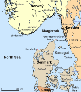
The Kattegat is a 30,000 km2 (12,000 sq mi) sea area bounded by the Jutlandic peninsula in the west, the Danish Straits islands of Denmark and the Baltic Sea to the south and the provinces of Bohuslän, Västergötland, Halland and Skåne in Sweden in the east. The Baltic Sea drains into the Kattegat through the Danish Straits. The sea area is a continuation of the Skagerrak and may be seen as a bay of the North Sea and North Atlantic Ocean, but in traditional Scandinavian usage, this is not the case.

Zealand at 7,031 km2 is the largest and most populous island in Denmark proper. Zealand had a population of 2,319,705 on 1 January 2020, comprising 40% of the country's population.

Sylt is a former island in northern Germany, part of Nordfriesland district, Schleswig-Holstein, well known for the distinctive shape of its shoreline. It belongs to the North Frisian Islands and is the largest island in North Frisia. The northernmost island of Germany, it is known for its tourist resorts, notably Westerland, Kampen and Wenningstedt-Braderup, as well as for its 40-kilometre-long (25-mile) sandy beach. It is frequently covered by the media in connection with its exposed situation in the North Sea and its ongoing loss of land during storm tides. Since 1927, Sylt has been connected to the mainland by the Hindenburgdamm causeway. In later years, it has been a resort for the German jet set and tourists in search of occasional celebrity sightings.

The Farne Islands are a group of islands off the coast of Northumberland, England. The group has between 15 and 20 islands depending on the level of the tide. They form an archipelago, divided into the Inner Group and the Outer Group. The main islands in the Inner Group are Inner Farne, Knoxes Reef, the East and West Wideopens, and the Megstone; the main islands in the Outer Group are Staple Island, Brownsman, North and South Wamses, Big Harcar, and Longstone. The two groups are separated by Staple Sound. The highest point, on Inner Farne, is 62 feet (19 m) above mean sea level.

Anglia is a small peninsula in northern Germany, on the Baltic coast of Jutland. Jutland consists of the mainland of Denmark and the northernmost German state of Schleswig-Holstein. Anglia belongs to the region of Southern Schleswig, which constitutes the northern part of Schleswig-Holstein. The region is often referred to in German as Landschaft Angeln or Halbinsel Angeln.

The North Jutlandic Island, Vendsyssel-Thy, or Jutland north of the Limfjord is the northernmost part of Denmark and of Jutland. It is more common to refer to the three traditional districts of Vendsyssel, Hanherred, and Thy. The area has been intermittently a tied island and, during modern times, was not surrounded by water until a storm in February 1825, which severed the region from the remainder of Jutland and caused a water connection between the North Sea and the western end of the Limfjord. Hence, it is traditionally regarded as a part of Jutland rather than a separate island.

Vendsyssel is the northernmost traditional district of Denmark and of Jutland. Being divided from mainland Jutland by the Limfjord, it is technically a part of the North Jutlandic Island which also comprises the areas Hanherred and Thy. Vendsyssel is part of the North Denmark Region.
The Limfjord is a shallow part of the sea, located in Denmark where it has been regarded as a inlet ever since Viking times. However, it now has entries both from the North Sea and Kattegat, and hence separates the North Jutlandic Island from the rest of the Jutland Peninsula. The Limfjord extends from Thyborøn Channel on the North Sea to Hals on the Kattegat. It is approximately 180 kilometres long and of an irregular shape with numerous bays, narrowings, and islands, most notably Mors, and the smaller ones Fur, Venø, Jegindø, Egholm and Livø. It is deepest at Hvalpsund.
Jutlandic, or Jutish, is the western variety of Danish, spoken on the peninsula of Jutland in Denmark.
South Jutlandic or South Jutish is a dialect of the Danish language. South Jutlandic is spoken in Southern Jutland on both sides of the border between Denmark and Germany.
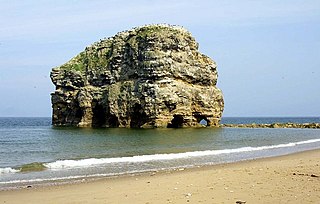
Marsden Rock is a rock in Tyne and Wear, North East England, situated in Marsden, South Shields. It is overlooked by the Marsden Grotto. The rock is a 90 feet (27 m) sea stack of Magnesian Limestone which lies approximately 300 feet (91 m) off the main cliff face. It was formerly known for its naturally-formed arch. The arch collapsed in 1996 following a winter of storms creating two separate stacks. The smaller of the two was demolished in 1997 due to safety concerns. The remaining stack is reachable on foot during low tide but is completely surrounded by water at high tide. The cliffs surrounding Marsden Rock are an important breeding ground for seabirds and colonies can often be seen on top of the rock itself, including kittiwakes, herring gulls, and razorbills.

North Frisia is the northernmost portion of Frisia, located in Schleswig-Holstein, Germany between the rivers Eider and Wiedau. It also includes the North Frisian Islands and Heligoland. The region is traditionally inhabited by the North Frisians.

Fowlsheugh is a coastal nature reserve in Kincardineshire, northeast Scotland, known for its 70-metre-high (230 ft) cliff formations and habitat supporting prolific seabird nesting colonies. Designated as a Site of Special Scientific Interest (SSSI) by Scottish Natural Heritage, the property is owned by the Royal Society for the Protection of Birds. Fowlsheugh can be accessed by a public clifftop trail, or by boats which usually emanate from the nearby harbour at the town of Stonehaven. Tens of thousands of pelagic birds return to the site every spring to breed, after wintering at sea or in more southern climates, principal species being puffins, razorbills, kittiwakes, fulmars and guillemots.

The Jutland horse is a draft horse breed originating in Denmark, named after the Jutland Peninsula which forms the western part of the country. Usually chestnut, they are a compact, muscular breed known for their calm and willing temperament. The breed was originally developed for use in agriculture, but today is more often seen in urban settings and at horse shows. Some of the best known members of the breed pull beer wagons for the Carlsberg brewery around Copenhagen, as well as at competitions and for demonstrations. Images from the 9th century show a horse similar to the Jutland being used by Viking raiders in what is now Great Britain. The first written record is from the 12th century, when they were popular as war horses. Some infusion of bloodlines from other breeds occurred in the 18th century, but the modern Jutland type only began about 1850 with the addition of blood from several other breeds, mainly draft horses. A stud book was created in the late 19th century, and the Jutland population grew to a maximum around 15,000 by 1950. Numbers subsequently declined, and as of 2011, only an estimated 1,000 horses remained.

Thy is a traditional district in northwestern Jutland, Denmark. It is situated north of the Limfjord, facing the North Sea and Skagerrak, and has a population of around 44,000. The capital is Thisted. Snedsted, Hanstholm and Hurup are minor towns in the area.

Han Herred or Hanherrederne is a traditional district in northern Jutland, Denmark. It lies between Thy in the west and Vendsyssel in the east. To the north it faces the North Sea (Skagerrak) and to the south the Limfjord. There are only two towns with more than 1,000 inhabitants, Fjerritslev and Brovst.

Kalø Castle is a ruined castle located in eastern Jutland, in Denmark, 20 km from the city of Aarhus within Mols Bjerge National Park.

Jutland is a peninsula of Northern Europe that forms the continental portion of Denmark and part of northern Germany (Schleswig-Holstein). It stretches from the Grenen spit in the north to the confluence of the Elbe and the Sude in the southeast. The historic southern border river of Jutland as a cultural-geographical region, which historically also included Southern Schleswig, is the Eider. The peninsula, on the other hand, also comprises areas south of the Eider: Holstein, the former duchy of Lauenburg, and most of Hamburg and Lübeck.

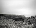
Thy National Park is a national park area in Thy, Denmark, opened to the public on 22 August 2008. It is located in Northwest Jutland, along the coast from Hanstholm to Agger Tange and it spans 55 km (34 mi) north to south and 5–12 km (3.1–7.5 mi) east to west. The total area of the national park is 244 km2.