Contents
- Danube
- Between Komárno and Štúrovo
- Between Komárno and Bratislava
- in Bratislava
- Váh river
- Water reservoirs
- Former islands
- References
This is a list of islands of Slovakia .
This is a list of islands of Slovakia .


Islands and islets on large man-made reservoirs.


Slovakia is a landlocked Central European country with mountainous regions in the north and flat terrain in the south. During much of the Holocene, Slovakia was much more forested than today. Decline of the forest occurred in as consequence of the Valachian colonization and the development of mining in the territory.

Komárno, colloquially also called Révkomárom, Öregkomárom, Észak-Komárom in Hungarian, is a town in Slovakia at the confluence of the Danube and the Váh rivers. Historically it was formed by the "old town" on the left bank of Danube, present day Komárno in Slovakia, and by a "new town" on the right bank, present day Komárom in Hungary, which were historically one administrative unit. Following World War I and the Treaty of Trianon, the border of the newly created Czechoslovakia cut the historical, unified town in half, creating two new independent towns in two countries. Komárno and Komárom are connected by the Elisabeth Bridge, which used to be an official border crossing between Slovakia and Hungary until border checks were lifted due to the Schengen Area rules. In 2020, a new road bridge was opened.

The Trnava Region is one of the eight Slovak administrative regions. It was established in 1996, before which date, most of its districts were parts of Bratislava Region which was established on the founding of Czechoslovakia in 1923. It consists of 251 municipalities, from which 16 have a town status. It is the second most densely populated region in Slovakia.

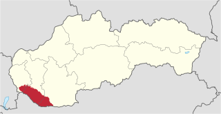
The Nitra Region is one of the administrative regions of Slovakia. It was first established in 1923 and from 1996 exists in its present borders. It consists of seven districts and 354 municipalities, from which 16 have a town status. The economy of the region focuses more on agriculture, than in other Slovak regions. Nitra is its seat, largest city, and cultural and economic center.
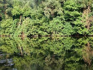
The Little Danube is a branch of the river Danube in Slovakia.
Žitný ostrov, also called Veľký Žitný ostrov to differentiate it from Malý Žitný ostrov, is a river island in southwestern Slovakia, extending from Bratislava to Komárno. It lies between the Danube, its tributary Little Danube and Váh. The island is a major part of the Danubian Flat. It is the biggest river island in Europe, with an area of 1,886 km2 (728 sq mi), measuring 84 km (52 mi) in length and 15 to 30 km in width.

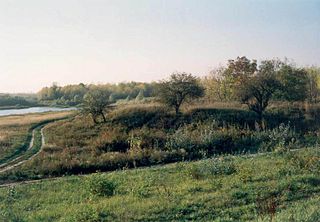
The Little Hungarian Plain or Little Alföld is a plain of approximately 8,000 km² in northwestern Hungary, south-western Slovakia, and eastern Austria. It is a part of the Pannonian plain which covers most parts of Hungary.

Kolárovo is a town in the south of Slovakia near the town of Komárno. It is an agricultural center with 11,000 inhabitants.
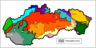
The Danubian Flat, also translated as Danubian Plain, is the south-western, flatter, part of the Danubian Lowland in Slovakia.
Fort Gúta was a fort near the town of Gúta in what is today Slovakia. As of today, no archaeological excavations have been done on its site.
Vieska is a village and municipality in the Dunajská Streda District in the Trnava Region of south-west Slovakia.

Madunice is a large village and municipality in Slovakia in Trnava region in Hlohovec District.
Iža is a village in south-western Slovakia.
The Dudváh is a lowland river in western Slovakia. Its source is located in the Čachtice Little Carpathians, and it mostly runs in parallel to the Váh river. It flows into the Váh near the village of Siladice. Its average discharge flow is 1.3 m³/s near Siladice. It is 41.7 km (25.9 mi) long and its basin size is 499 km2 (193 sq mi). Its former lower course, the Dolný Dudváh, branches off close to Siladice and flows towards the south. Near the town Čierna Voda, the Dolný Dudváh flows into the river Čierna voda, which in turn flows into the Little Danube. The Dolný Dudváh is 34.2 km (21.3 mi) long and its basin size is 751 km2 (290 sq mi).

Dunajské luhy Protected Landscape Area is one of the youngest of the 14 protected landscape areas in Slovakia. The Landscape Area consists of five separate parts in the Danube Lowland, stretching from Bratislava in the north west, following the Danube and the borders between Slovakia and Hungary to a river island called Veľkolélsky ostrov in Komárno District. The biggest part is Žitný ostrov, the largest river island in Europe.

Slovakia was partly occupied by Roman legions for a short period of time. Marcomannia was a proposed province of the Roman Empire that Emperor Marcus Aurelius planned to establish in this territory. It was inhabited by the Germanic tribes of Marcomanni and Quadi, and lay in the western parts of the modern states and Slovakia and the Czech Republic (Moravia). Part of the area was occupied by the Romans under Marcus Aurelius between 174 AD and 180 AD. His successors abandoned the project, but the people of the area became steadily Romanized during the next two centuries. The Roman influence was disrupted with the invasions of Attila starting around 434 AD and as Slavic people later began to move into the area.

Devín Carpathians is a subdivision of the Little Carpathians mountain range, located entirely within Bratislava, the capital of Slovakia. It is bordered by the city boroughs of Devín from the west, Devínska Nová Ves from the north, Dúbravka from the east and Karlova Ves from the south. Its highest mountain is Devínska Kobyla at 514 m AMSL, it is also the highest point in Bratislava. The hills are mostly forested with deciduous trees and most of the area is protected by numerous nature reserves, including two geologically important areas: Sandberg containing sands and sandstones from the Cenozoic Paratethys ocean and Jezuitské Lesy containing rare granitic pegmatite bearing niobium-tantalum oxide minerals.
| Sovereign states |
| |
|---|---|---|
| States with limited recognition | ||
| Dependencies and other entities | ||
| Authority control databases: National |
|---|
