Greece has many islands, [Note 1] with estimates ranging from somewhere around 1,200 [1] to 6,000, [2] depending on the minimum size to take into account. The number of inhabited islands is variously cited as between 166 [3] and 227. [2]
Contents
- Islands of Greece by size
- Islands of Greece by population
- Islands of the Aegean Sea
- Argo-Saronic Islands
- Cretan islands
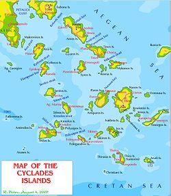
- Cyclades islands
- Dodecanese islands
- Euboea and surrounding islands
- North Aegean islands
- Sporades islands
- Ionian Sea islands
- Islets close to mainland
- Islands not in the sea
- Lake and river islands
- Islands in an island
- Lagoon islands
- See also
- Notes
- References
- External links
The largest Greek island by both area and population is Crete, located at the southern edge of the Aegean Sea. The second largest island in area is Euboea or Evvia, which is separated from the mainland by the 60 m wide Euripus Strait, and is administered as part of the Central Greece region. After the third and fourth largest Greek islands, Lesbos and Rhodes, the rest of the islands are two-thirds of the area of Rhodes, or smaller.
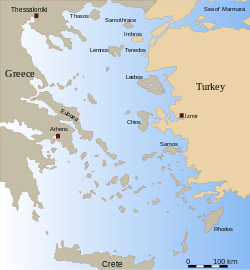
The Greek islands are traditionally grouped into the following clusters: the Saronic Islands (pink) in the Saronic Gulf near Athens; the Cyclades (purple), a large but dense collection occupying the central part of the Aegean Sea; the North Aegean islands (yellow, and emerald), a loose grouping off the west coast of Turkey; the Dodecanese (red), another loose collection in the southeast between Crete and Turkey; the Sporades (olive), a small tight group off the coast of Euboea; and the Ionian Islands (light red), chiefly located to the west of the mainland in the Ionian Sea. Crete with its surrounding islets and Euboea are traditionally excluded from this grouping.
Some Greek islands are often located off the coasts of modern countries whose shores were already inhabited by Greeks before antiquity, such as the coasts of Asia Minor and northern Epirus. It was only in the 20th century that the displacement of Greek populations led to a change in the ethnic landscape: today, Greek-populated islands are situated near regions now inhabited by other ethnic groups, such as in Turkey (Asia Minor) and southern Albania (Northern Epirus).
This article excludes the Peloponnese, which has technically been an island since the construction of the Corinth Canal in 1893, but is rarely considered to be an island due to its artificial origins.