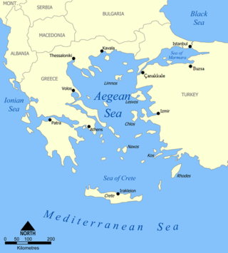
The Aegean Sea is an elongated embayment of the Mediterranean Sea between Europe and Asia. It is located between the Balkans and Anatolia, and covers an area of some 215,000 km2 (83,000 sq mi). In the north, the Aegean is connected to the Marmara Sea, which in turn connects to the Black Sea, by the straits of the Dardanelles and the Bosphorus, respectively. The Aegean Islands are located within the sea and some bound it on its southern periphery, including Crete and Rhodes. The sea reaches a maximum depth of 3,544 m (11,627 ft) to the east of Crete. The Thracian Sea and the Sea of Crete are main subdivisions of the Aegean Sea.
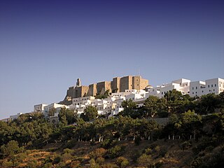
Patmos is a Greek island in the Aegean Sea. It is famous as the location where John of Patmos received the visions found in the Book of Revelation of the New Testament, and where the book was written.

Icaria, also spelled Ikaria, is a Greek island in the Aegean Sea, 10 nautical miles (19 km) southwest of Samos.
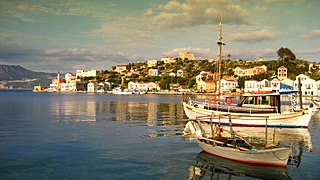
Kastellorizo or Castellorizo, officially Megisti, is a Greek island and municipality of the Dodecanese in the Eastern Mediterranean. It lies roughly 2 kilometres off the south coast of Turkey, about 570 km (354 mi) southeast of Athens and 125 km (78 mi) east of Rhodes, almost halfway between Rhodes and Antalya, and 280 km (170 mi) northwest of Cyprus. Kastellorizo is part of the Rhodes regional unit.
The Dodecanese are a group of 15 larger and 150 smaller Greek islands in the southeastern Aegean Sea and Eastern Mediterranean, off the coast of Turkey's Anatolia, of which 26 are inhabited. This island group generally defines the eastern limit of the Sea of Crete. They belong to the wider Southern Sporades island group.

Paxos is a Greek island in the Ionian Sea, lying just south of Corfu. As a group with the nearby island of Antipaxos and adjoining islets, it is also called by the plural form Paxi or Paxoi. The main town and the seat of the municipality is Gaios. The smallest of the seven main Ionian Islands, Paxos has an area of 25.3 square kilometres (9.8 sq mi), while the municipality has an area of 30.121 km2 (11.630 sq mi) and a population of about 2,500.

Symi, also transliterated as Syme or Simi, is a Greek island and municipality. It is mountainous and has the harbour town of Symi and its adjacent upper town Ano Symi, as well as several smaller population centres, beaches and areas of significance in history and mythology. Symi is part of the Rhodes regional unit.

Leros, also called Lero, is a Greek island and municipality in the Dodecanese in the southern Aegean Sea. It lies 317 kilometres from Athens's port of Piraeus, from which it can be reached by a nine-hour ferry ride or by a 45-minute flight from Athens. It is about 32 kilometres (20 mi) from Turkey. Leros is part of the Kalymnos regional unit. It has a population of 7,992 (2021).
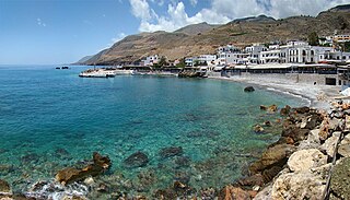
Hóra Sfakíon or Sfakia is a town on the south coast of Crete, Greece. It is the capital of the remote and mountainous region of Sfakiá, and is a small town of just 322 inhabitants. It lies on the south coast near the end of the Imbros Gorge, 74 km south of Chania. It has two small harbours, where the ferry boats from Agia Roumeli dock, which in the summer bring the hikers from the Samaria Gorge to take buses back to the northern coast. From Hóra Sfakíon ferries also go to the nearby coastal town of Loutro and the island Gavdos.

Leipsoi is an island south of Samos and to the north of Leros in Greece. It is well serviced with ferries passing between Patmos and Leros and on the main route for ferries from Piraeus. Leipsoi is a small group of islets at the northern part of the Dodecanese near to Patmos island and Leros. The larger Leipsi-Arkoi archipelago consists of some 37 islands and islets of which only three are larger than 1 square kilometre : Leipsoi, Arkoi and Agreloussa. Only Leipsoi, Arkoi and Marathos are inhabited. Leipsoi is a municipality, part of the Kalymnos regional unit, which is part of the South Aegean region. The municipality has an area of 17.350 square kilometres (6.699 sq mi). In ancient times, it contained a town named Lepsia.
Tílos is a small Greek island and municipality located in the Aegean Sea. It is part of the Dodecanese group of islands, and lies midway between Kos and Rhodes. In 2021, the island had a population of 746 people. Along with the uninhabited offshore islets of Antitilos and Gaidaros, it forms the Municipality of Tilos, which has a total land area of 64.525 square kilometres (24.913 sq mi). Tilos is part of the Rhodes regional unit.

Fournoi Korseon, more commonly simply Fournoi, anciently known as Corsiae or Korsiai, Corseae or Korseai (Κορσεαί), Corsia or Korsia (Κορσία), and Corassiae (Κορασσίαι), form a complex or archipelago of small Greek islands that lie between Ikaria, Samos and Patmos in Ikaria regional unit, North Aegean region. The two largest islands of the complex, the main isle of Fournoi 31 square kilometres and the isle of Thymaina 10 square kilometres, are inhabited, as is Agios Minas Island 2.3 square kilometres to the east. The municipality has an area of 45.247 km2. On the main isle Fournoi (town) is the largest settlement and then Chrysomilia in the north the second largest. Fournoi (town) proper is the main ferry harbour, with ferries also landing on Thymaina.

Samos is a Greek island in the eastern Aegean Sea, south of Chios, north of Patmos and the Dodecanese archipelago, and off the coast of western Turkey, from which it is separated by the 1.6-kilometre-wide (1.0 mi) Mycale Strait. It is also a separate regional unit of the North Aegean region.
Farmakonisi is a small Greek island and community of the Dodecanese, in the Aegean Sea, Greece. It lies in the middle between the chain of the Dodecanese islands in the west, and the coast of Asia Minor (Turkey) in the east. To the north of it are the island of Agathonisi, to the west the islands of Leipsoi, Patmos and Leros, and to the south the islands of Kalymnos and Pserimos. It forms part of the municipality of Leros, and had at the 2021 census a population of 21 inhabitants. Prominent historical monuments on the island include the church of Agios Georgios and the nearby ruins of an ancient Roman temple.

Samiopoula is a Greek islet located on the south of Samos Island and at a distance of 0.85 km (0.46 nmi). It is under the authority of the regional unit of Samos and the local jurisdiction of the municipal unit of Pythagoreio. The 2001 census reported a population of five inhabitants. The name Samiopoula is a derivative of Samos and literally means "small Samos".
The Dodecanese campaign was the capture and occupation of the Dodecanese islands by German forces during World War II. Following the signing of the Armistice of Cassibile on 3 September 1943, Italy switched sides and joined the Allies. As a result, the Germans made plans to seize control of the Dodecanese, which were under Italian control. The Allies planned to use the islands as bases to strike against German targets in the Balkans, which the Germans aimed to forestall.

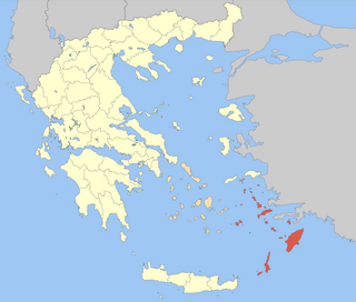
Kalymnos is one of the regional units of Greece. It is part of the region of South Aegean. The regional unit covers the islands of Kalymnos, Agathonisi, Astypalaia, Leipsoi, Leros, Patmos and several smaller islands in the Aegean Sea.
Marathos or Marathi is a small Greek Island in the Aegean Sea lying east of Patmos island, southwest of Arkoi island, and northwest of Leipsoi island. It is part of the Dodecanese archipelago. It is a small island with an area of 36 hectares but there are a couple of tavernas and few rooms to let.

Dodekanisos Seaways is a Greek ferry company operating from the island of Rhodes to smaller Dodecanese islands and islands of the Northeastern Aegean. Its itineraries cover 17 island destinations: Rhodes, Symi, Panormitis Symi, Kos, Kalymnos, Leros, Lipsi, Patmos, Agathonisi, Kastellorizo, Halki, Tilos, Nisyros, Arkoi, Samos, Ikaria and Fourni. Dodekanisos Seaways owns two catamaran speedboats, the Dodekanisos Express and the Dodekanisos Pride as well as the conventional ship Panagia Skiadeni. Dodekanisos Seaways was awarded as the Best Shipping Company of the year 2015, by Lloyd's List, in the context of the Greek Shipping Awards 2015, while among others, it was awarded praise by the Greek Red Cross, the Municipality of Rhodes and the Central Port Authority of Rhodes.

Eastern Sporades or Eastern Islands was the name of one of the thirteen divisions created in 1828 with the administrative division of the newly formed Hellenic State by the government of Ioannis Kapodistrias.


