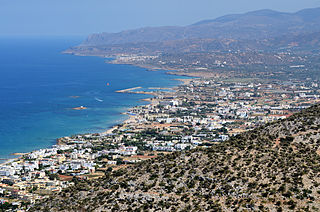
Malia or Mallia is a coastal town and a former municipality in the northeast corner of the Heraklion regional unit in Crete, Greece. Since the 2011 local government reform it is part of the municipality Hersonissos, of which it is a municipal unit. It lies 34 kilometres east of Heraklion, the Cretan capital city. The town was the seat of the municipality of Mália. The municipal unit also includes the villages of Mochos (825), Krasi (147), and Stalida (1,237), and has a total land area of 60.720 square kilometres (23.444 sq mi). The town is a tourist attraction, primarily for its significant archaeological site and nightlife. The Minoan town ruins lie three km east of the site and cover an area of approximately 1 square kilometre (0.4 sq mi). The original name for the town is not known.

Kalymnos, is a Greek island and municipality in the southeastern Aegean Sea. It belongs to the Dodecanese and is located to the west of the peninsula of Bodrum, between the islands of Kos and Leros : the latter is linked to it through a series of islets. Kalymnos lies between two and five hours away by sea from Rhodes.

Agathonísi is a small Greek island and municipality located at the northernmost point of the Dodecanese in Greece. It is surrounded by many smaller islands and is home to two villages, both inland; Megálo Chorió, and Mikró Chorió. Between them is the small settlement of Agios Georgios, which forms the island's only harbor and consists of a few hotels and restaurants. The island is also locally known as Gaidaro ("Donkey"), or by its ancient name Tragea.

Dikti or Dicte is a mountain range on the east of the island of Crete in the regional unit of Lasithi. On the west it extends to the regional unit of Heraklion. According to some Greek mythology, Zeus was reared on this mountain in a cave called Dictaeon Antron. On the north of the main massif, the Lasithi Plateau is located. The topology of the mountain range is rich with plateaus, valleys and secondary peaks. Some important peaks are Spathi 2148m, Afentis Christos/Psari Madara 2141m, Lazaros 2085m, Madara 1783m, Skafidaras 1673m, Katharo Tsivi 1665m, Sarakino 1588m, Afentis 1571m, Selena 1559m, Varsami 1545m, Toumpa Moutsounas 1538m, Platia Korfi 1489m, Mahairas 1487m, Virgiomeno Oros 1414m,. The main massif forms a horseshoe around the valley of Selakano. Large parts of the mountain area, including the Selakano valley, are forested with pines, Kermes oaks, cypresses, Holm Oaks and Cretan Maples. The fertile valleys and plateaus of Dikti/Dicte are of significant importance in the local economy.

Makry Gialos is a former municipality in Lasithi, Crete, Greece, with a population 3,894 in 2011. It is located on the south-east coast of Crete. Since the 2011 local government reform it is part of the municipality Ierapetra, of which it is a municipal unit. The municipal unit has an area of 159.229 km2 (61.479 sq mi). The seat of the municipality was in Koutsouras, 22 kilometers east of Ierapetra. It was established in 1998 when the communities of Schinokapsala, Orino, Stavrochori, Chrisopigi, Aghios Stefanos, Pefki, Lithines and Pervolakia amalgamated into one municipality (Δήμος).

Samiopoula is a Greek islet located on the south of Samos Island and at a distance of .85 km (0.46 nmi). It is under the authority of the regional unit of Samos and the local jurisdiction of the municipal unit of Pythagoreio. The 2001 census reported a population of five inhabitants. The name Samiopoula is a derivative of Samos and literally means "small Samos".
Christos Kapralos was a Greek artist of the 20th century. He was born in Panaitolio in the former municipality of Thesties, near Agrinio.
Monolithos is a Greek village on the island of Rhodes, South Aegean region, belonging to the municipal unit of Attavyros. It is located 10 km south-east of Apolakkia and 30 km from Prasonisi.

Imia or Kardak is a pair of small uninhabited islets in the Aegean Sea, situated between the Greek island chain of the Dodecanese and the southwestern mainland coast of Turkey.
Agia Varvara is the name of several towns :

Malia is a village in the Limassol District of Cyprus, located 4 km south of Omodos.

Souda is an islet in Souda Bay on the northwest coast of Crete. In ancient times this islet was one of two islets that were referred to as Leukai. The second islet is known today as Leon.

Pontikonisi is a Greek islet near the island of Corfu. Its prominent feature is a Byzantine chapel of Pantokrator, dating from the 11th or 12th century.

Leon, also known colloquially as Nisi and during Venetian rule as Rabbit Island, is an islet in Souda Bay on the northwest coast of Crete.
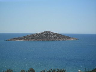
Agia Varvara is a small islet off the northern coast of the Greek island of Crete in the Aegean Sea. It is a short distance from the islet of Afentis Christos at Malia. The islet is administered from Malia in Heraklion regional unit.
Daskaleia, is an uninhabited Greek islet, in the Aegean Sea, close to the northeastern coast of Crete. The small islet lies close to the island of Kyriamadi. Administratively it lies within the Itanos municipality of Lasithi.
Karavi, is an uninhabited Greek islet, in the Aegean Sea, close to the northeastern coast of eastern Crete. The small islet lies close to the island of Kyriamadi. Administratively it lies within the Itanos municipality of Lasithi.
Koursaroi, also known as Nisaki, is an islet close to the eastern coast of Crete, and north-east of the islet of Praso, in the Aegean Sea. Administratively, it is located within the municipality of Kissamos, in Chania regional unit.
Boğsak is a Mediterranean islet in Mersin Province, Turkey.


