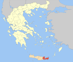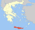
Crete is the largest and most populous of the Greek islands, the 88th largest island in the world and the fifth largest island in the Mediterranean Sea, after Sicily, Sardinia, Cyprus, and Corsica. Crete is located about 100 km (62 mi) south of the Peloponnese, and about 300 km (190 mi) southwest of Anatolia. Crete has an area of 8,450 km2 (3,260 sq mi) and a coastline of 1,046 km (650 mi). It bounds the southern border of the Aegean Sea, with the Sea of Crete to the north and the Libyan Sea to the south. Crete covers 260 km from west to east but is narrow from north to south, spanning three longitudes but only half a latitude.

Heraklion or Herakleion, sometimes Iraklion, is the largest city and the administrative capital of the island of Crete and capital of Heraklion regional unit. It is the fourth largest city in Greece with a municipal population of 179,302 (2021) and 211,370 in its wider metropolitan area, according to the 2011 census. The greater area of Heraklion has been continuously inhabited since at least 7000 BCE, making it one of the oldest inhabited regions in Europe. It is also home to the ancient Knossos Palace, a major center of the Minoan civilization dating back to approximately 2000-1350 BCE, often considered Europe's oldest city. The palace is one of the most significant archaeological sites in Greece, second only to the Parthenon in terms of visitor numbers.

Myrtos is a coastal village and a community in the west of the municipality of Ierapetra, in the Regional Unit of Lasithi on the Greek island of Crete. It is located 50 km (31 mi) from Agios Nikolaos and 15 km (9.3 mi) from Ierapetra, on the road to Viannos. A little to the west of the village is the iconic conical Kolektos mountain. Myrtos is situated on the Libyan Sea. The patron saint of the village is Saint Anthony. The population of the community is 518 (2021).

Sitia or Siteia is a port town and a municipality in Lasithi, Crete, Greece. The town has 11,166 inhabitants and the municipality has 20,438 (2021). It lies east of Agios Nikolaos and northeast of Ierapetra. Sitia's port is on the Sea of Crete, part of the Aegean Sea and is one of the economic centers of the Lasithi region. European route E75 starts in Sitia. Sitia is served by the Sitia Public Airport. Sitia has not experienced the effects of mass tourism even though there is a long beach along the road leading to Vai and several places of historical interest.

Ierapetra is a Greek city and municipality located on the southeast coast of Crete.

Agios Nikolaos or Aghios Nikolaos is a coastal city on the Greek island of Crete, lying east of the island's capital Heraklion, north of the city of Ierapetra and west of the city of Sitia.

Neapoli is a small town and a former municipality in Lasithi, eastern Crete, Greece. Since the 2011 local government reform, it has been treated as a municipal unit of Agios Nikolaos. The municipal unit has an area of 130.450 km2 (50.367 sq mi). It is located 12 kilometres west from Agios Nikolaos in the green valley of Mirabello. The surrounding area is mountainous and home to a collection of native olive trees. Neapoli is a traditional Cretan town with narrow streets and cobbled roads. The Cathedral of the Virgin Mary is located on the central square.
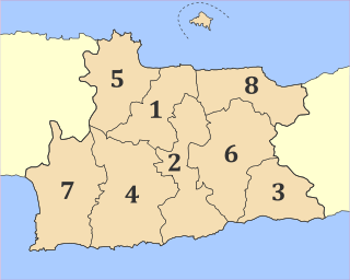
Heraklion is one of the four regional units of Crete. The capital is the city of Heraklion.

Makry Gialos is a former municipality in Lasithi, Crete, Greece, with a population 2,589 in 2021. It is located on the south-east coast of Crete. Since the 2011 local government reform it is part of the municipality Ierapetra, of which it is a municipal unit. The municipal unit has an area of 75.376 km2 (29.103 sq mi). The seat of the municipality was in Koutsouras, 22 kilometers east of Ierapetra. It was established in 1997 when the communities of Stavrochori, Chrysopigi, Lithines, Schinokapsala, Agios Stefanos, Oreino, Perivolakia and Pefkoi amalgamated into one municipality (Δήμος). In November 2011 the four communities Chrysopigi, Lithines, Perivolakia and Pefkoi passed to the municipality Siteia.

The Lasithi Plateau is a high endorheic plateau, located in the Lasithi regional unit in eastern Crete, Greece. Since the 1997 Kapodistrias reform, it is a municipality whose seat is Tzermiado and the second biggest village is Agios Georgios. The municipality has an area of 129.9 km2.

Males is a historic village in the municipality of Ierapetra in Lasithi prefecture on Crete. It is situated 25 kilometers north-west of Ierapetra, 40 from Agios Nikolaos and 12 kilometers away from the sea. Together with nearby hamlets Hristos and Metaxohori Males until recently formed the Nea Mala municipality. It is built 550 meters above sea level, south east of Dikti mountain, in an area rich in vegetation. It is built where the ancient city of Mala was.
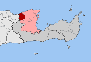
Vrachasi is a village and a former municipality in the Lasithi regional unit, Crete, Greece. Since the 2011 local government reform it is part of the municipality of Agios Nikolaos, of which it is a municipal unit. The municipal unit has an area of 63.41 km2 (24.48 sq mi).

Toplou Monastery is a currently active monastery located in a semi-arid area of the Lasithi regional unit, on the eastern part of the island of Crete in Greece. It is about 6 km (3.7 mi) north of Palekastro and 85 km (53 mi) east of Agios Nikolaos. It is at the base of the Itanos promontory from which Cape Sidero, the easternmost point of Crete, projects to the northeast. The nearest settlements are Sitia to the west and Palaikastro to the southeast; otherwise, the entire promontory is uninhabited except for the modern military reservation at the tip of the cape. In the political structure of Greece, the monastery has been assigned the settlement (oikismos) of Toplou, which it had before 2011, but was validated again in the redivision of 2011. The full civic classification beyond Toplou from 2011 in ascending order is: local community Palaikastro, municipal unit Itanos, municipality (demos) Siteia, regional unit Lasithi, region (periphereia) Crete.

Gramvousa, also Grampousa, refers to two small uninhabited islands off the coast of a peninsula also known Gramvousa Peninsula in north-western Crete in the regional unit of Chania. The Gramvousa Peninsula forms the more westerly of the two pairs of peninsulae in northwestern Crete, and is the western part of Kissamos Bay.
Agios Stefanos is a village within the Lasithi prefecture in eastern Crete. It belonged to the former province of Siteia until that was abolished in 2006. Between 1997 and 2010, it was part of the former Makry Gialos municipality. Today, it is part of Ierapetra municipality. It is located 30 kilometers north-east of Ierapetra, 40 kilometers southwest of Sitia, and six kilometers east of Stavrohori. It can be approached through the famous forest of Pefkoseli. Its patron is Saint Stephen. Saint Stephen church, at the entrance of the village, is an ecclesiastical and historical monument of Crete. Since the last decade, the majority of the population has been moved to the village's seaside settlement of Makry Gialos, some six kilometers to the south. Makry Gialos is one of Crete's most important tourist resorts.

Rethymno is a city in Greece on the island of Crete. It is the capital of Rethymno regional unit, and has a population of more than 35,000 inhabitants.

Sisi, or Sissi is a small Greek resort in the municipal unit Vrachasi, Agios Nikolaos, Lasithi, Crete. It is situated on the north coast, 6 km northwest of Vrachasi and 6 km east of Malia, 22 km northwest of Agios Nikolaos and 35 km east of Heraklion.
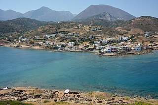
The Sitia or Siteia Mountains, also known as the Sitiaka Range, are a group of four mountain ranges extending SW-NE in Lasithi in eastern Crete, Greece. Stretching from the southern coast to the plain of the city of Sitia on the northern coast, they tend to isolate east Crete from the rest of Crete, creating a refugium for the rare plant and animal species and a refuge for the ancient people practising the Minoan culture. In this ancient refuge are now to be found the ruins of Minoan sites at Mochlos, Kato Zakro, Palaikastro, and Kavousi. These are four of the major sites of East Crete, but the number of sites recorded or excavated is in the hundreds. Endemic species, many rare or endangered, are to be found in the gorges that cut from upland to ocean or valley on all sides.
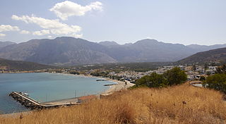
Pacheia Ammos is a village in the municipality of Ierapetra on the island of Crete in Greece. It is located on the north coast of the island, 15 km to the north of the city of Ierapetra, at the fork in the road that leads to Heraklion in the west and Sitia in the east.
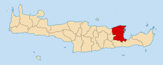
The municipality of Agios Nikolaos is a municipality located in the region of Crete, in Greece. The current municipality is the result of the merger in 2011 between the former municipalities of Agios Nikolaos, Neapoli and the community of Vrachasi, which became municipal units.


