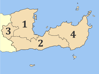
Lasithi is the easternmost regional unit on the island of Crete, to the east of Heraklion. Its capital is Agios Nikolaos, the other major towns being Ierapetra, Sitia and Neapoli. The mountains include the Dikti in the west and the Thrypti in the east. The Sea of Crete lies to the north and the Libyan Sea to the south.

Sitia is a port town and a municipality in Lasithi, Crete, Greece. The town has 9,912 inhabitants (2011) and the municipality has 18,318 (2011). It lies east of Agios Nikolaos and northeast of Ierapetra. Sitia port is on the Sea of Crete, part of the Aegean Sea and is one of the economic centers of the Lasithi region. European route E75, which ends in Vardø, starts in Sitia. Sitia is served by the Sitia Public Airport. Sitia has not experienced the effects of mass tourism even though there is a long beach along the road leading to Vai and several places of historical interest.

Ierapetra is a town and municipality on the south coast of Crete.
Koutsouras (Κουτσουράς) is a village in Lasithi regional unit, in Crete, Greece 22 kilometers east of Ierapetra. Its population is 818. It was the headquarters of the municipality of Makry Gialos and is the biggest village in the region. Key industries include agriculture and tourism. It has nice beaches and a golf course is due to be built over the next five years. The coast is rocky and there are beautiful pebble beaches with crystal clear waters. Today it is the seat of Makry Gialos unity and part of Ierapetra municipality.

Episkopi Ierapetras is a village on the Greek island of Crete. Episkopi belongs to the municipality of Ierapetra in the prefecture of Lasithi. It lies north of Ierapetra in the middle of the narrowest part of the island. The village has approximately one thousand inhabitants.
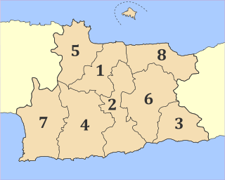
Heraklion is one of the four regional units of Crete. The capital is the city of Heraklion.
Karfi is an archaeological site high up in the Dikti Mountains in eastern Crete, Greece. The ancient name of the site is unknown; "Karfi" is a local toponym for the prominent knob of limestone that marks the peak of the site, especially when viewed from the north. Located approximately 1100 meters above sea level, and overlooking the northern entrance to the Lasithi Plateau, the dramatic situation of Karfi is somewhat akin to that of the famous Inca site of Machu Picchu in Peru. While there is some evidence that the site was used during the Middle Minoan period as a peak sanctuary, Karfi is best known as a large and extensively excavated town of the Late Minoan IIIC period at the beginning of the Greek "Dark Ages."

Ziros is a village in the municipality Sitia, Lasithi regional unit, Crete, Greece. It was the seat of government for the former municipality Lefki.

Anatoli is a small village in the Ierapetra municipality of the prefecture of Lasithi in eastern Crete. It is built 600 meters above sea level and the view over Ierapetra to the sea with Chrysi island opposite, is unique. It is called the "Libyan sea balcony". Despite the destruction of the surrounding wooded area, due to fire in recent years, the whole landscape is fantastic.

The Lasithi Plateau, sometimes spelt Lassithi Plateau is a high endorheic plateau, located in the Lasithi regional unit in eastern Crete, Greece. Since the 1997 Kapodistrias reform, it is a municipality whose seat is Tzermiado, although the biggest village is Agios Georgios. The municipality has an area of 129,9 km2.
Schinokapsala is a community and a small village in Lasithi on Crete. It is situated 21 kilometers north-east from Ierapetra and 6 km from the sea. Since 2011 it belongs to the Ierapetra municipality.
Oreino is a small village in Lasithi regional unit on Crete, Greece. It is situated 28 kilometers northeast of Ierapetra and lies 10 kilometers from the Cretan south coast. Since 2011 it belongs to Ierapetra municipality. It is situated at 650 meters above sea level, east of Thrypti mountain, in an area rich in vegetation.
Males is a historic village in the municipality of Ierapetra in Lasithi prefecture on Crete. It is situated 25 kilometers north-west of Ierapetra, 40 from Agios Nikolaos and 12 kilometers away from the sea. Together with nearby hamlets Hristos and Metaxohori Males until recently formed the Nea Mala municipality. It is built 550 meters above sea level, south east of Dikti mountain, in an area rich in vegetation. It is built where the ancient city of Mala was.
Ano Simi is a village on Crete in the prefecture of Lasithi. It is part of Ierapetra municipality and borders Viannos municipality. It lies about 900 meters above sea level, south of Mount Dikti in what is probably the most wooded area of Crete. It is about 1 kilometer from Kato Simi, and 32 kilometers from Ierapetra.
Limnes is a traditional Cretan small village in Lasithi, Crete, Greece, located 10 km from Agios Nikolaos. It is surrounded by olive trees and mountains.
Exo Lakkonia is a traditional village with small population near Agios Nikolaos of Crete. It has a folklore museum and some traditional coffee shops and an old church of St. George. It is located in a plain between the Oropedio Lasithiou and the area of Agios Nikolaos. A lot of European people have invested in the property in the area. It is also famous for a spring of water coming from the Lasithi mountain.

Priniatikos Pyrgos is an archaeological site near Istron River, in the eastern Cretan regional unit of Lasithi, (Greece). The nearest big town is Agios Nikolaos, Crete. The site is on a coastal promontory. It appears to have been first settled in the Final Neolithic, circa 3000 BC. Nearby, there's a small resort town of Kalo Chorio, Lasithi. It is not to be confused with Myrtos Pyrgos on the south coast.
Prosfora, is an uninhabited Greek islet, close to the coast of Lasithi, eastern Crete. Administratively it lies within the Sitia municipality of Lasithi.

Sisi, or Sissi is a small Greek resort in the municipal unit Vrachasi, Lasithi, Crete. It is situated on the north coast, 6 km northwest of Vrachasi and 6 km east of Malia, 22 km northwest of Agios Nikolaos and 35 km east of Heraklion.
Mirampello was one of the 4 provinces in Lasithi Prefecture of Greece. Its territory corresponded with that of the current municipality Agios Nikolaos, except the village Exo Potamoi. It was abolished in 2006.


