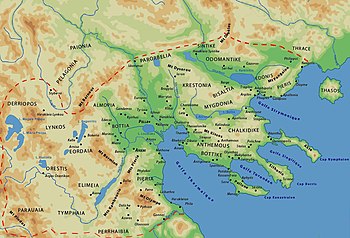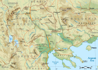
Macedonia is a geographical and historical region of the Balkan Peninsula in Southeast Europe. Its boundaries have changed considerably over time; however, it came to be defined as the modern geographical region by the mid-19th century. Today the region is considered to include parts of six Balkan countries: all of North Macedonia, large parts of Greece and Bulgaria, and smaller parts of Albania, Serbia, and Kosovo. It covers approximately 67,000 square kilometres (25,869 sq mi) and has a population of around five million. Greek Macedonia comprises about half of Macedonia's area and population.

Thessaly is a traditional geographic and modern administrative region of Greece, comprising most of the ancient region of the same name. Before the Greek Dark Ages, Thessaly was known as Aeolia, and appears thus in Homer's Odyssey.
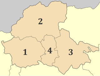
Pella is one of the regional units of Greece, in the geographic region of Macedonia. It is part of the Region of Central Macedonia. It is named after the ancient city of Pella, the capital of ancient Macedonia and the birthplace of Alexander the Great. The capital of Pella is Edessa with a population of 19,036 inhabitants according to the census of 2021, while the largest town is Giannitsa. Other towns include Aridaia, Skydra, Arnissa, Exaplatanos and Krya Vrysi.
The Megleno-Romanians, also known as Meglenites, Moglenite Vlachs or simply Vlachs, are an Eastern Romance ethnic group, originally inhabiting seven villages in the Moglena region spanning the Pella and Kilkis regional units of Central Macedonia, Greece, and one village, Huma, across the border in North Macedonia. These people live in an area of approximately 300 km2 in size. Unlike the Aromanians, the other Romance-speaking population in the same historic region, the Megleno-Romanians are traditionally sedentary agriculturalists, and not traditionally transhumants. Sometimes, the Megleno-Romanians are referred as "Macedo-Romanians" together with the Aromanians.

Kilkis is one of the regional units of Greece, in the geographic region of Macedonia. It is part of the region of Central Macedonia. Its capital is the city of Kilkis.
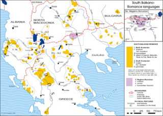
Megleno-Romanian is an Eastern Romance language, similar to Aromanian. It is spoken by the Megleno-Romanians in a few villages in the Moglena region that spans the border between the Greek region of Macedonia and North Macedonia. It is also spoken by emigrants from these villages and their descendants in Romania, in Turkey by a small Muslim group, and in Serbia. It is considered an endangered language.

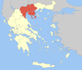
Macedonia is a geographic and former administrative region of Greece, in the southern Balkans. Macedonia is the largest and second-most-populous geographic region in Greece, with a population of 2.36 million. It is highly mountainous, with major urban centres such as Thessaloniki and Kavala being concentrated on its southern coastline. Together with Thrace, along with Thessaly and Epirus occasionally, it is part of Northern Greece. Greek Macedonia encompasses entirely the southern part of the wider region of Macedonia, making up 51% of the total area of that region. Additionally, it widely constitutes Greece's borders with three countries: Albania to the northwest, North Macedonia to the north, and Bulgaria to the northeast.

Babaeski is a town in Kırklareli Province in the Marmara region of Turkey. It is the seat of Babaeski District. Its population is 29,215 (2022).
Minorities in Greece are small in size compared to Balkan regional standards, and the country is largely ethnically homogeneous. This is mainly due to the population exchanges between Greece and neighboring Turkey and Bulgaria, which removed most Muslims and those Christian Slavs who did not identify as Greeks from Greek territory. The treaty also provided for the resettlement of ethnic Greeks from those countries, later to be followed by refugees. There is no official information for the size of the ethnic, linguistic and religious minorities because asking the population questions pertaining to the topic have been abolished since 1951.

The name Macedonia is used in a number of competing or overlapping meanings to describe geographical, political and historical areas, languages and peoples in a part of south-eastern Europe. It has been a major source of political controversy since the early 20th century. The situation is complicated because different ethnic groups use different terminology for the same entity, or the same terminology for different entities, with different political connotations.
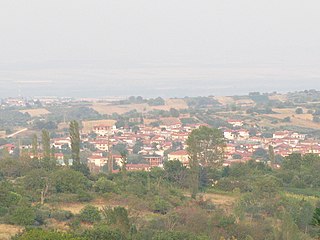
Goumenissa is a small traditional town in the Kilkis regional unit, Macedonia, Greece. Since the 2011 local government reform it is part of the Paionia Municipality, of which it is a community and a municipal unit. The municipal unit has an area of 208.949km2. The 2021 census recorded 3,292 residents in the community and 5,157 residents in the municipal unit. The town sits on the southeastern part of the Paiko mountain range. Located 69 km northwest of Thessaloniki, 539 km north of Athens and 20 km north of Pella, the ancient capital of the Greek kingdom of Macedonia. Goumenissa is the seat of the Greek Orthodox diocese of Goumenissa, Axioupoli and Polykastro.

Aridaía ) is a town and a former municipality in the Pella regional unit, Greece. Since the 2011 local government reform, it is part of the Almopia municipality, of which it is a municipal unit. It was the capital of the former Almopia eparchy. It is located in the northwest corner of the Pella regional unit, bordering the southern part of the North Macedonia and the northeast corner of the Florina regional unit. Its land area is 562.910 km2 (217.341 sq mi). The population of Aridaia proper is 7,118, while that of the entire municipal unit is 18,864. The municipal unit is divided into 17 communities. Its largest other communities are Prómachoi, Loutráki (1,176) and Sosándra (1,008).
Exaplatanos is a village and a former municipality in the Pella regional unit, Greece. Since the 2011 local government reform it is part of the municipality Almopia, of which it is a municipal unit. The municipal unit has an area of 422.907 km2. Population 6,105 (2021). In 1912 the village numbered 1,315 residents exclusively Pomak Muslims.

Edessa, until 1923 Vodena, is a city in northern Greece and the capital of the Pella regional unit, in the Central Macedonia region of Greece. It was also the capital of the defunct province of the same name.
Nótia is a village in the Exaplatanos municipal unit of the Pella regional unit, Macedonia, Greece.
Almops was, in Greek mythology, a giant son of the god Poseidon and the half-nymph Helle. He was the brother of Paeon.

Kilkis is a city in Central Macedonia, Greece. As of 2021 there were 24,130 people living in the city proper, 27,493 people living in the municipal unit, and 45,308 in the municipality of Kilkis. It is also the capital city of the regional unit of Kilkis.

The Greek state has systematically pursued a policy of Hellenisation following its independence from the Ottoman Empire in the early 1830s. This ideology included replacing all geographical and topographic names with revived names rooted in Classical Greece – that is, any name deemed foreign, divisive against Greek unity, or considered to be "bad Greek" was hidden or assimilated. The names that were considered foreign were usually of Albanian, Slavic or Turkish origin. Byzantine Greek was considered bad Greek at the time of the establishment of the state until well after the Balkan Wars; accordingly those places were also renamed.
Agios Athanasios (Greek: Άγιος Αθανάσιος, before 1926: Τσεγάνη village in the Pella regional unit of Macedonia, Greece. The village is located north of Lake Vegoritida within the Vegoritida municipal unit which belongs to the municipality of Edessa.

Pella is a town in the Pella municipality in the Pella regional unit of Macedonia, Greece. Pella is built on a hill at a distance of one kilometre from the road Thessaloniki - Edessa, and the archeological site Pella and 7 km from Giannitsa. The community of Pella has an area of 30.09 km2, and a population of 2,050 inhabitants (2021). The municipal unit covers 113.819 km2.