
The Kızılırmak, also known as the Halys River is the longest river entirely within Turkey. It is a source of hydroelectric power and is not used for navigation.

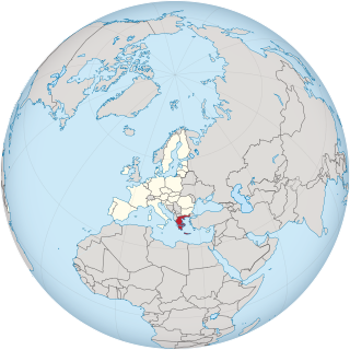
Aetolia-Acarnania is one of the regional units of Greece. It is part of the geographic region of Central Greece and the administrative region of West Greece. A combination of the historical regions of Aetolia and Acarnania, it is the country's largest regional unit. Its capital is Missolonghi for historical reasons, with its biggest city and economic centre at Agrinio. The area is now connected with the Peloponnese peninsula via the Rio-Antirio Bridge. The surrounding regional units take in Arta in Epirus, a narrow length bordering Karditsa of Thessaly, Evrytania to the northeast, and Phocis to the east.

The provinces of Greece were sub-divisions of some the country's prefectures. From 1887, the provinces were abolished as actual administrative units, but were retained for some state services, especially finance services and education, as well as for electoral purposes. Before the Second World War, there were 139 provinces, and after the war, with the addition of the Dodecanese Islands, their number grew to 147. According to the Article 7 of the Code of Prefectural Self-Government, the provinces constituted a "particular administrative district" within the wider "administrative district" of the prefectures. The provinces were finally abolished after the 2006 local elections, in line with Law 2539/1997, as part of the wide-ranging administrative reform known as the "Kapodistrias Project", and replaced by enlarged municipalities (demoi).

The Ambracian Gulf, also known as the Gulf of Arta or the Gulf of Actium, and in some official documents as the Amvrakikos Gulf, is a gulf of the Ionian Sea in northwestern Greece. About 40 km (25 mi) long and 15 km (9 mi) wide, it is one of the largest enclosed gulfs in Greece, and due to its ecological importance is one of the National Parks of Greece. The towns of Preveza, Amphilochia, and Vonitsa lie on its shores.

Anaktorio is a former municipality in Aetolia-Acarnania, West Greece, Greece. Since the 2011 local government reform it is part of the municipality Aktio-Vonitsa, of which it is a municipal unit. The municipal unit has an area of 214.112 km2. The municipal unit is mainly flat and has a total population of 9,129 residents according to the 2011 census, roughly half of which are found in the town of Vonitsa.
Fyteies is a village and a former municipality in Aetolia-Acarnania, West Greece, Greece. Since the 2011 local government reform it is part of the municipality Xiromero, of which it is a municipal unit. The municipal unit has an area of 96.295 km2. Population 2,154 (2011).
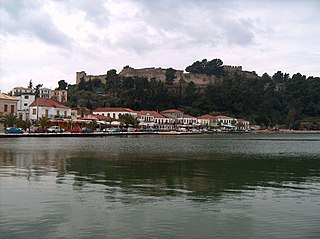
Vonitsa is a town in the northwestern part of Aetolia-Acarnania in Greece, seat of the municipality of Aktio-Vonitsa. Population 4,916 (2011). The beach town is situated on the south coast of the Ambracian Gulf, and is dominated by a Venetian fortress on a hill. Vonitsa is 13 kilometres southeast of Preveza, 18 kilometres northeast of Lefkada (city) and 90 kilometres northwest of Agrinio. The Greek National Road 42 passes through Vonitsa.
The Greek National Road 42 is a highway in northwestern Aetolia-Acarnania and in Lefkada, Greece. It links the town of Lefkada with the Greek National Road 5 in Amfilochia, passing through the town of Vonitsa.
This page list topics related to Greece.
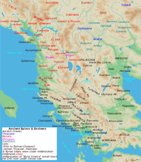
Alyzeia or Alyzia (Ἀλυζια), was a town on the west coast of ancient Acarnania. According to Strabo it was distant 15 stadia from the sea, on which it possessed a harbour and a sanctuary, both dedicated to Heracles. In this sanctuary were some works of art by Lysippus, representing the Labours of Heracles, which a Roman general caused to be removed to Rome on account of the deserted state of the place. The remains of Alyzia are still visible in the valley of Kandili. The distance of the bay of Kandili from the ruins to Leucas corresponds with the 120 stadia which Cicero assigns for the distance between Alyzia and Leucas. Alyzia is said to have derived its name from Alyzeus, a son of Icarius. It is first mentioned by Thucydides; in 375 BCE, a naval battle was fought in the neighbourhood of Alyzia between the Athenians under Timotheus and the Lacedaemonians under Nicolochus. The Athenians, says Xenophon, erected their trophy at Alyzia, and the Lacedaemonians in the nearest islands. We learn from the Periplus of Pseudo-Scylax that the island immediately opposite Alyzia was called Carnus, the modern Kalamos.
Agios Nikolaos is a village in the municipal unit of Eleios-Pronnoi on the island Cephalonia, Greece. Its population is 96 people. It is situated in an inland valley, at 280 m elevation. It is 3 km southeast of Digaleto, 4 km north of Xenopoulo, 6 km northwest of Poros and 20 km east of Argostoli. The road from Poros to Sami passes through the village. Agios Nikolaos suffered great damage from the 1953 Ionian earthquake. The village has an elementary school and a church named Saint Nicholas.

European route E 952 is a European B class road in Greece, connecting the city Preveza – Lamia.
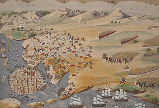
The Second Siege of Missolonghi was a second attempt by Ottoman forces to capture the strategically located port town of Missolonghi during the third year of the Greek War of Independence (1823). The second siege is usually ignored however, and the name is often applied to the greater siege of 1825–1826.
Xiromero municipality is a municipality in the Aetolia-Acarnania regional unit, West Greece region, Greece. The seat of the municipality is the town Astakos. Its borders do not coincide with the historical region of Xiromero, which extends to parts of the territory of the neighbouring municipality of Aktio-Vonitsa and most notably the area around Katouna. The municipality has an area of 590.113 km2.

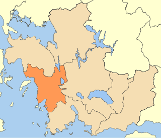
Aktio–Vonitsa is a municipality in the Aetolia-Acarnania regional unit, West Greece region, Greece. The seat of the municipality is the town of Vonitsa. The municipality has an area of 660.172 km2.

Motorway 52 (A52) or Amvrakia Odos is a tangential motorway of the A5 motorway in Aetolia-Acarnania, Greece. The A52 is an important motorway for the tourist region of the Ambracian Gulf. Its construction should have been finished until 2012, however the ongoing crisis in the country has delayed its completion. The Motorway connects the Airport of Aktio the Island of Lefkada and the A5. The construction started In July 2009. It will be 48,5 km long and it will have 4 lanes (2+2) with hard shoulder and median, but without emergency lane. As of 2019, only the 15 km Vonitsa - Aktio section has been opened to traffic, while the remaining 44 km are not scheduled to open before 2021-2022.
Karli-Eli, also Karli-Ili or Karlo-Ili, was the Ottoman name for the region of Aetolia-Acarnania in western Greece, which formed a distinct administrative unit from the late 15th century until the Greek War of Independence.
Drymos, Aetolia-Acarnania is a settlement located roughly between the cities of Amfilochia and Vonitsa. It is near the ancient town of Drymus. Recent archaeological excavations have uncovered an early Christian basilica on the outer perimeter of the settlement.

Aiolos Astakou B.C. is a Greek professional basketball club. The club is located in Astakos, Aetolia-Acarnania, Greece. The club's full name is A.M.S. Aiolos Astakou. The club is named after the Greek god Aeolus. The club's name can be translated into English as Aeolus Lobster.
The 23 October 1862 Revolution was a popular insurrection which led to the overthrow of King Otto of Greece. Starting on 18 October in Vonitsa, it soon spread to other cities and reached Athens on 22 October.
