
Chaeronea is a village and a former municipality in Boeotia, Greece, located about 80 kilometers east of Delphi. Since the 2011 local government reform it is part of the municipality Livadeia, of which it is a municipal unit. The municipal unit has an area of 111.445 km2, the community 26.995 km2. Population 1,382 (2011). It is located by the mountain Thourion and in the Kifisós river valley, NW of Thebes.

Continental Greece, colloquially known as Roúmeli (Ρούμελη), is a traditional geographic region of Greece. In English the area is usually called Central Greece, but the equivalent Greek term is more rarely used.

Greek National Road 48 is a single carriageway road in central Greece. It connects the Greek National Road 5 at Antirrio with the town Livadeia, passing through Naupactus and Delphi. The section between Antirrio and Itea is part of European route E65. The GR-48 passes through the regional units Aetolia-Acarnania, Phocis and Boeotia.
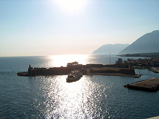
Antirrio is a town and a former municipality in Aetolia-Acarnania, West Greece, Greece. Since the 2011 local government reform it is part of the municipality Nafpaktia, of which it is a municipal unit. The municipal unit has an area of 50.794 km2.

Arachova is a mountain town and a former municipality in the western part of Boeotia, Greece, originally called Karyai. Since the 2011 local government reform it is a municipal unit, part of the municipality Distomo-Arachova-Antikyra. Its name is of South Slavic origin and denotes a place with walnut trees. It is a tourist destination due to its location in the mountains, its traditions and its proximity to the town of Delphi.

Itea, is a town and a former municipality in the southeastern part of Phocis, Greece. Since 2011 local government reforms made the city a part of the municipality Delphi, of which it is a municipal unit.

Davleia is a village and a former municipality in Boeotia, Greece. Since the 2011 local government reform it is part of the municipality Livadeia, of which it is a municipal unit. Its name comes from the ancient settlement Daulis. The municipal unit has an area of 94.985 km2, the community 61.725 km2. The municipality includes the eastern portion of Mount Parnassos. Phthiotis lies to the north. Davleia is located ESE of Lamia, SW of Kamena Vourla, W of Livadeia and Thiva, NE of Itea and E of Delphi.
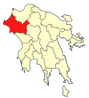
Elis was one of the provinces of the Elis Prefecture. The seat of administration was Pyrgos. Its territory corresponded with that of the current municipalities Andravida-Kyllini, Ilida, Olympia, Pineios and Pyrgos. It was abolished in 2006.
Sapes is a town and a former municipality in the Rhodope regional unit, East Macedonia and Thrace, Greece. Since the 2011 local government reform it is part of the municipality Maroneia-Sapes, of which it is the seat and a municipal unit. The municipal unit has an area of 354.596 km2. The population is 8,383 (2011).

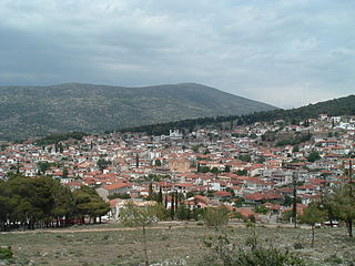
Livadeia is a town in central Greece. It is the capital of the Boeotia regional district. Livadeia lies 90 km (56 mi) north-west of Athens, 64 km (40 mi) west of Chalkida, 63 km (39 mi) south-east of Lamia, 44 km (27 mi) east-south-east of Amfissa, and 91 km (57 mi) east-north-east of Nafpaktos. The town lies some five kilometres (3.1 mi) west of Greek National Road 3, to which it is linked by National Road 48.

Distomo is a town in western Boeotia, Greece. Since the 2011 local government reform it is part of the municipality Distomo-Arachova-Antikyra, of which it is the seat and a municipal unit. The municipal unit has an area of 131.270 km2, the community 80.498 km2. Population 3,881 (2011). Distomo is situated in the western foothills of Mount Helicon, at about 450 m elevation. It is 5 km north of the Gulf of Corinth coast, 9 km southeast of Arachova, 12 km east of Desfina, 16 km southeast of Delphi, 18 km west of Livadeia and 105 km northwest of Athens. The Greek National Road 48 passes north of the town.
Koroneia is a village and a former municipality in Boeotia, Greece. Since the 2011 local government reform it is part of the municipality Livadeia, of which it is a municipal unit. The population of the municipal unit was 3,170 at the 2011 census.
Temenos is a former municipality in the Heraklion Regional Unit, Crete, Greece. Since the 2011 local government reform it is part of the municipality Heraklion, of which it is a municipal unit. The municipal unit has an area of 56.608 km2. Population 3,260 (2011). The seat of the municipality was in Profitis Ilias.
Desfina is a town and a former municipality in the southern part of Phocis, Greece. Since the 2011 local government reform it is part of the municipality Delphi, of which it is a municipal unit. The municipal unit has an area of 148.992 km2. At the 2011 census, its population was 1,988. It is situated on a plateau at 680m elevation, 5 km from the Corinthian Gulf. It is 7 km southeast of Delphi, 9 km east of Itea and 30 km west of Livadeia.
Paralia Distomou, also known as Aspra Spitia, is a town in the municipal unit Distomo-Arachova-Antikyra, in Boeotia, Greece. In 2011, its population was 1,578.
Kallithea is a village and a community in the municipal unit of Tolofon, southern Phocis, Greece. The community consists of the villages Kallithea, Agia Eirini, Agios Nikolaos, Agios Spyridonas, Klovinos, Flampourakia and the uninhabited islands Agios Nikolaos and Prasoudi. Kallithea is situated in the mountains near the coast of the Gulf of Corinth. The two largest villages, Agios Nikolaos and Agios Spyridonas, are on the coast. Kallithea is 5 km northwest of Tolofon, 26 km southwest of Amfissa and 27 km east of Nafpaktos. The Greek National Road 48 passes along the coast. There is a ferry service from Agios Nikolaos to Aigio, Peloponnese.
Messini is a municipal unit and seat (edra) of the municipality (dimos) of Messini within the regional unit of Messenia in the region (perifereia) of Peloponnese, one of 13 regions into which Greece has been divided. Before 2011 the same hierarchy prevailed, according to Law 2539 of 1997, the Kapodistrias Plan, except that Messenia was a nomos and the Municipal unit was a locality. The dimos existed under both laws, but not with the same constituents.

Livadhe is a village and a former municipality in Vlorë County, southern Albania. At the 2015 local government reform it became a subdivision of the municipality Finiq. The population at the 2011 census was 1,165. The municipal unit consists of the villages Livadhja, Kulluricë, Llazat, Kalcat, Kodër, Lefter Talo, Vagalat, Gravë, Qesarat, Komat, Karroq, Grazhdan and Zminec all inhabited solely by Greeks, while Sopik is inhabited by an Orthodox Albanian population and Pandalejmon by Muslim Cham Albanians. A study by Leonidas Kallivretakis in 1993 found that the population of the commune consisted of 85% ethnic Greek Christians, 10% Albanian Christians, and 5% Albanian Muslims.
Edessa Province was one of the three provinces of Pella Prefecture of Greece. Its territory corresponded with that of the current municipalities Edessa and Skydra. It was abolished in 2006.

Paionia is a municipality in the Kilkis regional unit of Central Macedonia, Greece. The seat of the municipality is the town Polykastro. The municipality is named after the ancient region of Paeonia. It has an area of 919.276 km2.


