Gastouni is a town and a former municipality in Elis, West Greece, Greece. Since the 2011 local government reform it is part of the municipality Pineios, of which it is the seat and a municipal unit. The municipal unit has an area of 59.325 km2. Gastouni is situated in a flat rural area, 5 km from the Ionian Sea. The river Pineios flows into the sea near Gastouni. The town is 6 km (4 mi) south of Andravida, 4 km (2 mi) east of Vartholomio, 11 km (7 mi) northwest of Amaliada and 26 km (16 mi) northwest of Pyrgos. The Greek National Road 9/E55 and the railway from Patras to Pyrgos pass east of Gastouni. There is a 12th-century Byzantine church in the southwestern quarter Katholiki.

Gargalianoi is a town and a former municipality in Messenia, Peloponnese, Greece. Since the 2011 local government reform it is part of the municipality Trifylia, of which it is a municipal unit. The municipal unit has an area of 122.680 km2. It is situated 4 km (2.5 mi) from the Ionian Sea coast, 18 km (11 mi) north of Pylos, 21 km (13 mi) south of Kyparissia and 43 km (27 mi) west of Kalamata. The Greek National Road 9 passes through the town.
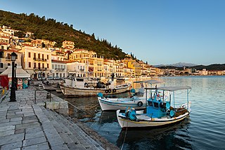
Gytheio or Gythio, also the ancient Gythium or Gytheion, is a town on the eastern shore of the Mani Peninsula, and a former municipality in Laconia, Peloponnese, Greece. Since the 2011 local government reform it is part of the municipality East Mani, of which it is a municipal unit. The municipal unit has an area of 197.313 km2.

Lasiona is a former municipality in Elis, West Greece, Greece. Since the 2011 local government reform it is part of the municipality Archaia Olympia, of which it is a municipal unit. The municipal unit has an area of 119.528 km2. Its seat of administration was the village Antroni. Lasiona is situated in a mountainous area on the border with Achaea, 20 km north of Olympia, 27 km northeast of Pyrgos and 50 km south of Patras. The Greek National Road 33 passes through the municipal unit.

Volakas is a former municipality in Elis, West Greece, Greece. After the administrative reform of 2011, it became a part of Pyrgos. The municipal unit has an area of 70.790 km2. Its seat of administration was in the town of Epitalio.
Skoutari is a village and a community of the municipality of East Mani. Before the 2011 local government reform it was a part of the municipality of Gytheio, of which it was a municipal district. The community of Skoutari covers an area of 11.667 km2. According to local tradition it was founded by refugees from the Fall of Constantinople in 1453.
Parasyros is a village of the municipality of East Mani. Before the 2011 local government reform it was a part of the municipality of Gytheio. Parasyros is part of the community of Skoutari. Parasyros is located 2 km west of Skoutari, 9 km east of Areopoli and 13 km southwest of Gytheio.

Drosopigi or "Tserova" is a small village in Mani, Laconia, Greece. It is part of the municipal unit of Gytheio. Drosopigi lies on a mountain around 400 m (1,300 ft) above sea level. Drosopigi has historic towers and because of its stoned houses, it has been declared as a traditional settlement.

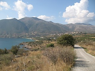
East Mani is a municipality in Laconia, Peloponnese, Greece. Its seat of administration is the town Gytheio. The municipality covers the southeastern part of the Mani region. It is a mountainous and rocky area. Its economy relies on fishing, olive oil and tourism.
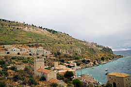
Pyrgos Dirou is a town in Mani, Laconia, Greece. It is part of the municipal unit of Oitylo of the municipality of East Mani. It is located around 26 km from Areopoli.
Kelefa is a castle and village in Mani, Laconia, Greece. It is part of the municipal unit of Oitylo.
Pyrrichos is one of the oldest towns in Mani peninsula, Laconia, Greece. It is part of the municipal unit East Mani. It was promised to Achilles by the Achaeans if he took part in the Trojan War.
Koita is a village in the Mani peninsula, Laconia, Greece. It is part of the municipal unit of Oitylo. It is built on top of a hill, overlooking the sea. Koita is known for its many Maniot pyrgoi. Partially abandoned, much of the population left between World War II and today. It was the scene of Mani's last vendetta, in 1870 which required the intervention of the army, with artillery to halt it. It is among the oldest villages in Mani, being mentioned in the Iliad as "Messes", a village in Menelaus' kingdom. Population 290 (2021).

Asterousia is a former municipality in the Heraklion regional unit, Crete, Greece. Since the 2011 local government reform it is part of the municipality Archanes-Asterousia, of which it is a municipal unit. The municipal unit has an area of 203.420 km2 (78.541 sq mi). Population 4,943 (2021). The seat of the municipality was in Pyrgos. Other villages include Charakas.

Ithomi is a former municipality in the Karditsa regional unit, Thessaly, Greece. Since the 2011 local government reform it is part of the municipality Mouzaki, of which it is a municipal unit. The municipal unit has an area of 80.491 km2. Population 1,591 (2011). The seat of the municipality was in Fanari. The name reflects the ancient town of Ithome, which, although its location is uncertain, is thought to be located nearby. The municipal unit Ithomi consists of the following communities:

Molaoi is a town and a former municipality in Laconia, Peloponnese, Greece. Since the 2011 local government reform it is part of the municipality Monemvasia, of which it is the seat and a municipal unit. The municipal unit has an area of 193.167 km2.

West Mani is a municipality in the Messenia regional unit, Peloponnese, Greece. The seat of the municipality is the town Kardamyli. The municipality has an area of 402.809 km2. It comprises the northwestern part of the Mani region. The southeastern part of Mani is covered by the municipality East Mani, in Laconia.
Kontovouni is a village and a community of the Kozani municipality. Before the 2011 local government reform it was part of the municipality of Elimeia, of which it was a municipal district. The 2021 census recorded 99 inhabitants in the community of Kontovouni. The community of Kontovouni covers an area of 5.226 km2.
Evangelismos is a village and a community of the Elassona municipality. Before the 2011 local government reform it was part of the municipality of Elassona, of which it was a municipal district. The community of Evangelismos covers an area of 23.634 km2.
Palaiokastro is a village and a community of the Elassona municipality. Before the 2011 local government reform it was part of the municipality of Elassona, of which it was a municipal district. The community of Palaiokastro covers an area of 17.532 km2.