Dodoni is a village and a municipality in the Ioannina regional unit, Epirus, Greece. The seat of the municipality is the village Agia Kyriaki.
Kefalovryso is a mountain village and a community of the Pogoni municipality. Before the 2011 local government reform it was a part of the municipality of Ano Pogoni, of which it was a municipal district and the seat. The community of Kefalovryso covers an area of 15.831 km2.
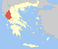
Ioannina is one of the regional units of Greece, located in the northwestern part of the country.
Agnanta is a village and a former municipality in the Arta regional unit, Epirus, Greece. Since the 2011 local government reform, it is part of the municipality Central Tzoumerka, of which it is a municipal unit. The municipal unit has an area of 124.344 km2. Agnanta is one of the largest villages of the Tzoumerka region. The population of the municipal unit is 1,860 (2021). It is located at a distance of 55 km north of the city of Arta and east of the city of Ioannina. The geographical center of the village has an altitude of 650–700 m, while some of its highest districts approach an altitude of 1000 m. The name Agnanta has its origin in the Greek adverb agnantia, which means across.

Athamania is a former municipality in the Arta regional unit, Epirus, Greece. Since the 2011 local government reform it is part of the municipality Central Tzoumerka, of which it is a municipal unit. The municipal unit has an area of 304.979 km2. Population: 3,026 (2021). The seat of the municipality was in Vourgareli.
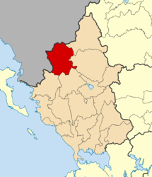
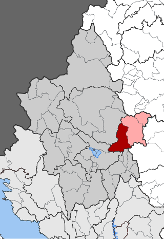
Agios Dimitrios is a former municipality in the Ioannina regional unit, Epirus, Greece. Since the 2011 local government reform it is part of the municipality Dodoni, of which it is a municipal unit. Population 3,277 (2021), its area is 231.473 km². The seat of the municipality was in Theriakisi. The largest village is Kato Mousiotitsa which has a school, gymnasium and lyceum. The municipal unit covers the northwestern part of the Xerovouni mountains.

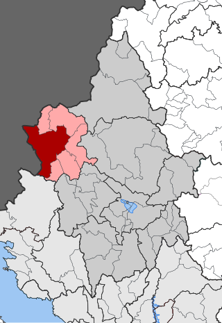
Ano Kalamas is a former municipality in the Ioannina regional unit, Epirus, Greece. Since the 2011 local government reform it is part of the municipality Pogoni, of which it is a municipal unit. The municipal unit has an area of 86.50 km2. Population 1,970 (2021). The seat of the municipality was in Parakalamos.

Ano Pogoni is a former municipality in the Ioannina regional unit, Epirus, Greece. Since the 2011 local government reform it is part of the municipality Pogoni, of which it is a municipal unit. The municipal unit has an area of 137.084 km2. The seat of the municipality was in Kefalovryso.
Delvinaki is a former municipality in the Ioannina regional unit, Epirus, Greece. Since the 2011 local government reform, it is part of the municipality Pogoni, of which it is a municipal unit. The municipal unit has an area of 255.8 km2, the community 54.8 km2. In 2021 its population was 538 for the village and 1,609 for the municipal unit. Delvinaki is part of the traditional area of Pogoni.
Egnatia is a former municipality in the Ioannina regional unit, Epirus, in northwestern Greece. Since the 2011 local government reform, it is part of the Metsovo municipality, of which it is a municipal unit. The municipal unit has an area of 131.424 km2. In 2021 its population was 1,867. The seat of the municipality was in Mikro Peristeri. The municipal unit is connected with both the GR-6/E92 and the new Via Egnatia.

Kalpaki is a former municipality in the Ioannina regional unit, Epirus, Greece. Since the 2011 local government reform it is part of the municipality Pogoni, of which it is a municipal unit. It is situated about 30 km (19 mi) northwest of Ioannina, and southwest of Konitsa. The municipal unit has an area of 116.756 km2, the community 13.189 km2. The Greek National Road 20 connects Kalpaki with Ioannina and Konitsa. The GR-22 connects Kalpaki with Kakavia, the border crossing into southern Albania.

Central Zagori is a former municipality in the Ioannina regional unit, Epirus, Greece. Since the 2011 local government reform, it has been part of the municipality Zagori, of which it is a municipal unit. The municipal unit has an area of 206.683 km2. Its population was 1,059 in 2021. The seat of the municipal unit is in Asprangeloi.

Bizani is a village and a former municipality in the Ioannina regional unit, Epirus, Greece. Since the 2011 local government reform it is part of the municipality Ioannina, of which it is a municipal unit. The municipal unit has an area of 91.372 km2, the community 11.660 km2. In 2021 its population was 4,387. The seat of the municipality was in Pedini. The municipal unit is situated in the plains and low hills south and southwest of Ioannina. The Greek National Road 5, the Greek National Road 17 and the Egnatia Odos motorway pass through the municipal unit.

Lavdani is a village and a former community in the Ioannina regional unit, Epirus, Greece. Since the 2011 local government reform it is part of the municipality Pogoni, of which it is a municipal unit. The municipal unit has an area of 48.191 km2, the community 31.866 km2. Population 119 (2021).

Vissani is a village in the municipal unit of Delvinaki, Ioannina regional unit, in the Epirus region of northwestern Greece. It is situated in the mountainous Pogoni area near the Albanian border, at 750 m above sea level. A small road connects Vissani with the Greek National Road 22 Kakavia - Kalpaki.
Ktismata is a village and a community in the municipal unit of Delvinaki, Ioannina regional unit, Epirus, in northwestern Greece. It is situated on a hillside on the right bank of the river Drinos, at 412 m above sea level. It is 3 km from the Greek - Albanian border at Kakavia. The community consists of the villages Ktismata and Neochori. Ktismata is 7 km southwest of Delvinaki, 30 km southeast of Gjirokastër (Albania) and 47 km northwest of Ioannina. The Greek National Road 22 passes north of the village.
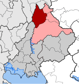
Dodoni Province was the largest of the four provinces of Ioannina Prefecture of Greece. Its territory corresponded with that of the current municipalities Dodoni, Ioannina, North Tzoumerka, Zagori and Zitsa, and the municipal units Ano Kalamas, Egnatia (partly) and Kalpaki. It was abolished in 2006.

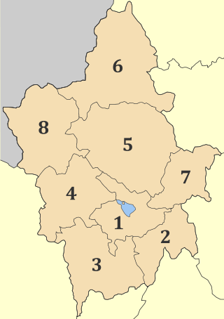
North Tzoumerka is a municipality in the Ioannina regional unit, Epirus, Greece. The seat of the municipality is the village Pramanta. The municipality has an area of 358.334 km2. The municipality is named after the Tzoumerka mountains.
Kouklioi is a village in the former municipality of Ano Kalamas, Ioannina regional unit, Epirus, Greece. Since the 2011 local government reform it is part of the municipality of Pogoni. Population 318 (2021).
Mavronoros is a village and a community of the Pogoni municipality. Before the 2011 local government reform it was a part of the municipality of Ano Kalamas, of which it was a municipal district. The 2021 census recorded 46 residents in the village. The community of Mavronoros covers an area of 5.805 km2.