
Kefalovryso is a mountain village and a community of the Pogoni municipality. Before the 2011 local government reform it was a part of the municipality of Ano Pogoni, of which it was a municipal district and the seat. The community of Kefalovryso covers an area of 15.831 km2.
Ioannina is one of the regional units of Greece, located in the northwestern part of the country.
Kryoneri may refer to numerous settlements in Greece:
Delvinaki is a former municipality in the Ioannina regional unit, Epirus, Greece. Since the 2011 local government reform, it is part of the municipality Pogoni, of which it is a municipal unit. The municipal unit has an area of 255.8 km2, the community 54.8 km2. In 2021 its population was 538 for the village and 1,609 for the municipal unit. Delvinaki is part of the traditional area of Pogoni.

Kalpaki is a former municipality in the Ioannina regional unit, Epirus, Greece. Since the 2011 local government reform it is part of the municipality Pogoni, of which it is a municipal unit. It is situated about 30 km (19 mi) northwest of Ioannina, and southwest of Konitsa. The municipal unit has an area of 116.756 km2, the community 13.189 km2. The Greek National Road 20 connects Kalpaki with Ioannina and Konitsa. The GR-22 connects Kalpaki with Kakavia, the border crossing into southern Albania.

Filippiada is a small town and a former municipality in the Preveza regional unit, Epirus, Greece. Since the 2011 local government reform it is part of the municipality Ziros, of which it is a municipal unit. The municipal unit has an area of 142.409 km2. It has a population of 8,325.
Vasiliko is a village in the municipality of Pogoni, Ioannina regional unit, Epirus, Greece. It is situated at an altitude of 800 m. It is 3 km east of Kefalovryso, 13 km west of Konitsa, 16 km south of Leskovik (Albania) and 44 km northwest of Ioannina.

Vissani is a village in the municipal unit of Delvinaki, Ioannina regional unit, in the Epirus region of northwestern Greece. It is situated in the mountainous Pogoni area near the Albanian border, at 750 m above sea level. A small road connects Vissani with the Greek National Road 22 Kakavia - Kalpaki.
Platanoussa is a village and a community in the municipal unit of Katsanochoria, Ioannina regional unit, Epirus, Greece. The community consists of the villages Platanoussa, Dafni and Zoodochos Pigi. Platanoussa is situated on the eastern slope of the Xerovouni mountain, above the right bank of the river Arachthos, at about 460 m above sea level. It is 8 km northeast of Anogeio, 29 km north of Arta and 31 km southeast of Ioannina.
Fortosi is a village and a community in the municipal unit of Katsanochoria, Ioannina regional unit, Epirus, Greece. The community consists of the villages Fortosi, Kostitsi, Patero and Nistora. Fortosi is situated in the northern foothills of the mountain Xerovouni, west of the Arachthos valley, at about 800 m elevation. It is 10 km west of Pramanta, 21 km southeast of Ioannina and 39 km north of Arta. There is an ancient castle built around the 4th century BC 2 km south of Patero.

Monastiri is a settlement in the Ioannina regional unit in Epirus, Greece. It is situated on the northwestern slopes of Smolikas, at the elevation of 950m. Below the village is the river Sarantaporos, which empties into the Aoos a few kilometers west before entering Albania. It is in the municipality of Konitsa. It is 1 km southwest of Molista, 10 km northeast of Konitsa and 18 km east of Leskovik (Albania).

Albanians in Greece are people of Albanian ethnicity or ancestry who live in or originate from areas within modern Greece. They are divided into distinct communities as a result of different waves of migration. Albanians first migrated into Greece during the late 13th century. The descendants of populations of Albanian origin who settled in Greece during the Middle Ages are the Arvanites, who have been fully assimilated into the Greek nation and self-identify as Greeks. Today, they still maintain their distinct subdialect of Tosk Albanian, known as Arvanitika, although it is endangered as the younger generations no longer speak it due to language attrition.

Plikati is a village in the municipal unit of Mastorochoria, Ioannina regional unit, Greece. It is one of the northernmost villages in Epirus. The village is situated at the foot of the Grammos mountains, at 1,240 m elevation, close to the Albanian border. Plikati is 3 km north of Gorgopotamos, 8 km west of Aetomilitsa, 9 km southeast of Ersekë (Albania) and 28 km north of Konitsa. Plikati has traditionally been populated by an Arvanite population and it is the only village today in Konitsa municipality where Albanian is still spoken. An Aromanian minority is also present in the village.

The Drino or Drinos is a river in southern Albania and northwestern Greece, and a tributary of the Vjosë. Its source is in the northwestern part of the Ioannina regional unit, near the village Delvinaki. The 84.6 km long Drino flows initially southwest, then northwest and crosses the Albanian border near Ktismata. It continues northwest through Gjirokastër and flows into the Vjosë near Tepelenë.

The Kakavia or Kakavijë border crossing is a major road border crossing between southern Albania and northwestern Greece. On the Albanian side lies the village of Kakavijë, located in the Gjirokastër County, Dropull region. On the Greek side lies the village of Ktismata, in the Delvinaki municipality, Ioannina regional unit. The main road from Sarandë and Gjirokastër to Ioannina passes through this border crossing. The Greek National Road 22 connects Kakavia with the GR-20 at Kalpaki.
Kastritsa is a village in the municipal unit of Pamvotida, Ioannina regional unit in Greece. It is situated on a hillside near the southern shore of Lake Ioannina. It is situated 2 km southwest of Vasiliki, 3 km east of Katsikas and 7 km southeast of Ioannina. The A2 motorway passes south of the village.
Seniko is a village and a community in the municipal unit of Selloi, Ioannina regional unit, Greece. The community includes the villages Domolessa and Mikrochori. It is built at 450 m above sea level, above the left bank of the river Tyria. It is 2.5 km north of Agios Nikolaos, 6 km south of Chinka, 13 km west of Dodoni and 23 km southwest of Ioannina.
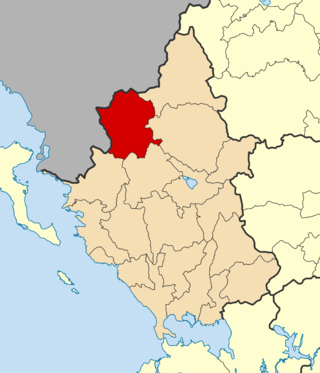
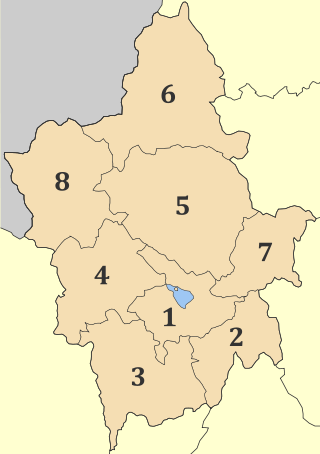
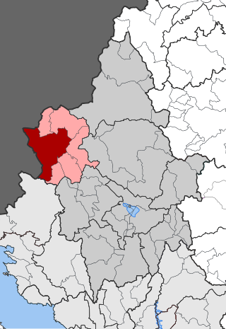
Pogoni is a municipality in the Ioannina regional unit, Epirus, Greece. The seat of the municipality is the village Kalpaki. The municipality has an area of 701.059 km2. Its population was 6,848 at the 2021 census.

Mousiotitsa or Kato Mousiotitsa is a village located in the Ioannina regional unit in the Epirus region of western Greece. Situated 33 km south of the city of Ioannina near the springs of the river Louros, the village consists of 4 areas: Kato Mousiotitsa, Ano Mousiotitsa, Nea Mousiotitsa and Mesoura. It is surrounded by 5 mountains: Bitera, Spithari, Pourizi, Kalogeritsa and Katafi.
