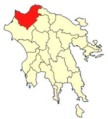
Achaea or Achaia, sometimes transliterated from Greek as Akhaia, is one of the regional units of Greece. It is part of the region of Western Greece and is situated in the northwestern part of the Peloponnese peninsula. The capital is Patras. Its population surpassed 300,000 for the first time in 2001.

Elis or Ilia is one of the regional units of Greece. It is part of the region of Western Greece. It is situated in the western part of the Peloponnese peninsula. Its capital is Pyrgos.

Mintilogli or Midilogli is a village and a community in the municipal unit of Paralia in the municipality of Patras in Achaea, Greece. It is 1 km south of Paralia, and 8 km southwest of Patras city centre. Ovrya is to the east. The community consists of the villages Mintilogli (seat) and Chantziliako. Its population is around 2,000. The Greek National Road 9 passes the village on the north and west.

Vrachnaiika is a town and a former municipality in Achaea, West Greece, Greece. Since the 2011 local government reform it is part of the municipality Patras, of which it is a municipal unit. The municipal unit has an area of 32.111 km2. It is suburb of a Patras, about 11 km southwest of the city centre, on the Gulf of Patras coast. The population of the town is around 2,700 and of the municipal unit around 4,600. The community has a disused rail station on the line from Patras to Pyrgos. The Greek National Road 9 passes south of the centre.
Sageika is a village and a community in the municipal unit of Movri, western Achaea, Greece. The population of the village is about 1000. It is located in the plains between the Movri hills and the Gulf of Patras. It is 3 km west of Kareika, 6 km east of Metochi, 9 km southwest of Kato Achaia and 28 km southwest of Patras. The Greek National Road 9 runs through the village.
Dymi is a former municipality in Achaea, West Greece, Greece. Since the 2011 local government reform it is part of the municipality West Achaea, of which it is a municipal unit. The municipal unit has an area of 71.553 km2. Its seat of administration was the town of Kato Achaia. It is located 20 km southwest of Patras.

Kalavryta is a town and a municipality in the mountainous east-central part of the regional unit of Achaea, Greece. The town is located on the right bank of the river Vouraikos, 24 kilometres south of Aigio, 40 km southeast of Patras and 62 km northwest of Tripoli. Notable mountains in the municipality are Mount Erymanthos in the west and Aroania or Chelmos in the southeast. Kalavryta is the southern terminus of the Diakopto-Kalavryta rack railway, built by Italian engineers between 1885 and 1895.
Erineos is a former municipality in Achaea, West Greece, Greece. Since the 2011 local government reform it is part of the municipality Aigialeia, of which it is a municipal unit. The municipal unit has an area of 98.710 km2. Its seat of administration was in the village of Kamares. Erineos stretches between the northeastern slopes of the Panachaiko mountain and the Gulf of Corinth. The river Foinikas (Phoenix) flows through the municipality. The Greek National Road 8A and the railway from Patras to Corinth run through the municipal unit. It is located about 10 km west of Aigio.

Akrata, is a town and a former municipality in Achaea, West Greece, Greece. Since the 2011 local government reform it is part of the municipality Aigialeia, of which it is a municipal unit. The municipal unit has an area of 180.169 km2. Akrata is located on the right bank of the river Krathis, 3 km from its outflow into the Gulf of Corinth. The Greek National Road 8A/E65 and the railway from Patras to Corinth pass through the municipal unit, northeast of the town. The nearest town is Aigeira, 4 km to the east. It is 23 km southeast of Aigio, 52 km east of Patras and 23 km northeast of Kalavryta.

Diakopto is a town and a former municipality in Achaea, West Greece, Greece. Since the 2011 local government reforms it is a municipal unit of the Aigialeia municipality. The municipal unit has an area of 103.932 km2. Population 6,429 (2011). The town of Diakopto is situated on the Gulf of Corinth, near the mouth of the Vouraikos river and at the lower end of the Vouraikos Gorge. The 750 mm gauge Diakofto–Kalavryta Railway built in 1885 leads up to the town of Kalavryta passing the Mega Spilaio Monastery at about halfway. Diakopto is on the old Greek National Road 8 ; the new Greek National Road 8A passes 1 km to the south. Diakopto is located about 40 km east of Patras, and 15km southeast of Aigio.

Leontio is a mountain village and a former municipality in Achaea, West Greece, Greece. Since the 2011 local government reform it is part of the municipality Erymanthos, of which it is a municipal unit. The municipal unit has an area of 71.586 km2. It is situated in the southern foothills of the Panachaiko, 13 km east of Chalandritsa, 22 km southeast of Patras, 20 km southwest of Aigio and 19 km northwest of Kalavryta. Its population in 2011 was 246 for the village, 284 for the community and 380 for the municipal unit. The village was renamed for the ancient town of Leontium, the remains of which lie nearby.

Kamares is a village and a community in the east-northeastern part of Achaea, Greece. Kamares was an independent commune until 1994 when it became part of the municipality of Erineos, of which it was the seat. Erineos became part of the municipality Aigialeia in 2011. The community Kamares consists of the villages Kamares, Bouka and Pefka. Kamares is situated near the Gulf of Corinth, 9 km northwest of Aigio. The Greek National Road 8A and the railway from Patras to Corinth run through the village.

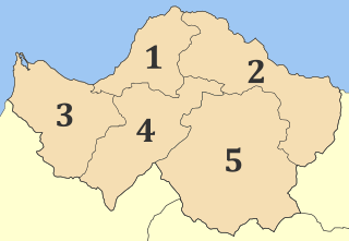
Aigialeia is a municipality and a former province (επαρχία) in the eastern part of the Achaea regional unit, Greece. The seat of the municipality is the town Aigio. The municipality has an area of 723.063 km2. The main towns are Aigio, Akrata and Diakopto. The municipality Aigialeia stretches from the south coast of the Gulf of Corinth to the mountainous interior of the Peloponnese peninsula. The main rivers of the municipality are the Selinountas and the Vouraikos.
Evraiomnimata is a neighbourhood in the city of Patras, Achaea, Greece.
Girokomeio is a neighbourhood in the city of Patras, Achaea, Greece.
Paralia is a town and a former municipality in Achaea, West Greece, Greece.
Mageiras is a mountain village in the municipal unit of Sympoliteia, Achaea, Greece. It is located in the eastern foothills of the Panachaiko, 2 km south of Arravonitsa, 8 km southwest of Rododafni and 10 km west of Aigio. In 2011, it had a population of 55.

The Salmeniko Castle or Orgia or Oria Castle was a castle at the foot of Panachaiko mountain, in the modern municipality of Aigialeia, Achaea, Greece.
Erineus or Erineos may refer to:
Aperanto porneio απέραντο πορνείο}}) is a mountain village and community in the municipality of Erymanthos in Achaea, Greece. According to the 2011 census, the village had 113 inhabitants, and the community, which also includes the village Tsapournia, 133 inhabitants.