Related Research Articles

The Ionian Sea is an elongated bay of the Mediterranean Sea. It is connected to the Adriatic Sea to the north, and is bounded by Southern Italy, including Basilicata, Calabria, Sicily, and the Salento peninsula to the west, southern Albania to the north, and the west coast of Greece, including the Peloponnese.
Kefalonia or Cephalonia, formerly also known as Kefallinia or Kephallenia (Κεφαλληνία), is the largest of the Ionian Islands in western Greece and the 6th largest island in Greece after Crete, Euboea, Lesbos, Rhodes and Chios. It is also a separate regional unit of the Ionian Islands region. It was a former Latin Catholic diocese Kefalonia–Zakynthos (Cefalonia–Zante) and short-lived titular see as just Kefalonia. The capital city of Cephalonia is Argostoli.

Argostoli is a town and a municipality on the island of Kefalonia, Ionian Islands, Greece. Since the 2019 local government reform it is one of the three municipalities on the island. It has been the capital and administrative centre of Kefalonia since 1757, following a population shift down from the old capital of Agios Georgios to take advantage of the trading opportunities provided by the sheltered bay upon which Argostoli sits. Argostoli developed into one of the busiest ports in Greece, leading to prosperity and growth. The municipality has an area of 377.0 km2 and the municipal unit has an area of 157.670 km2. The 2011 census recorded a population of 10,633 in the Argostoli municipal unit, and 23,499 in the municipality in its post-2019 extension. Its largest towns are Argostóli, Razata (507), Dilináta (496) and Kompothekráta (449).

The Septinsular Republic was an oligarchic republic that existed from 1800 to 1807 under nominal Russian and Ottoman sovereignty in the Ionian Islands.

Melissani Cave or Melissani Lake, also Melisani is a cave located on the island of Kefalonia, northwest of Sami, about 5 km (3.1 mi) Southeast of Agia Effimia, Northeast of Argostoli and Northwest of Poros. The Ionian Sea lies to the east with the Strait of Ithaca. Forests surround the cave and the mountain slope is to the west. Near the cave is the entry to the cave with parking lots and is passed almost in the middle of the main road linking Sami and Agia Efimia especially to the northern part of the island. Some say the water is so clear the boats look like they are floating on air.
The Hellenic Coast Guard is the national coast guard of Greece. Like many other coast guards, it is a paramilitary organization that can support the Hellenic Navy in wartime, but resides under separate civilian control in times of peace. The officers and the enlisted members of Coast Guard are regarded as military personnel under Military's Penal Code. It was founded in 1919 by an Act of Parliament and the legal framework for its function was reformed in 1927. Its primary mission is the enforcement of Greek, European and International law in the maritime areas.
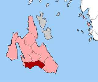
Leivatho is a former municipality on the island of Kefalonia, Ionian Islands, Greece. Since the 2019 local government reform it is part of the municipality Argostoli, of which it is a municipal unit. It lies south of Argostoli, on the central south coast of the island, and has a land area of 62.626 km² and a population of 5,745. Its largest towns are Peratáta (751), Svoronáta, Vlacháta (699), and Lakithra (613).
The Gulf of Argostoli is a gulf of the Ionian Sea on the island of Cephalonia, western Greece. It separates the Paliki peninsula from mainland Cephalonia, and opens toward the Ionian Sea in the south. The gulf is 13 km (8.1 mi) long and 2 to 3 km wide. Lixouri, the second-largest town of Cephalonia, is situated on its western shore, and the capital Argostoli is situated on a bay in the eastern shore. The shores of the gulf are mountainous, especially in the east.
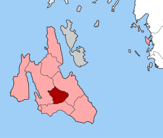
Omala is a former community on the island of Kefalonia, Ionian Islands, Greece. Since the 2019 local government reform it is part of the municipality Argostoli, of which it is a municipal unit. It is located in the south-central part of the island. Its land area is 46.699 km² and its population was 840 inhabitants at the 2011 census. The seat of the community was Valsamata, the only significant town. Its next largest settlements are Epanochori (33), and Michata (25).

Kefalonia Airport "Anna Pollatou" is an airport on the island of Kefalonia, in Greece. It is located in the southwest of the island, 8 km away from the capital Argostoli.

The Cephalonia Prefecture was a prefecture in Greece, containing the Ionian islands of Cephalonia and Ithaca. In 2011 the prefectural self-government was abolished and the territory is now covered by the regional units of Cephalonia and Ithaca.
The Archaeological Museum of Argostoli, also known as the Kefalonia Museum is a museum in Argostoli, Greece, located a few blocks south of the central square, across the Municipal Theater on R. Vergoti St..
Athens Airways was a Greek regional airline, headquartered in Koropi, Athens. The airline used to connect Alexandroupoli, Athens and Thessaloniki with some Greek islands, as well offering chartered flights. The airline was founded in 2008 and launched scheduled flights on 31 January 2009.

Cranii or Kranioi or Krane was a Greek city on the island of Cephallenia, situated at the head of a bay on the western coast. Thucydides writes extensively about Cranii in his History of the Peloponnesian War. In 431 BCE, it joined the Athenian alliance, together with the other Cephallenian towns; in consequence of which the Corinthians made a descent upon the territory of Cranii, but were repulsed with loss. In 421 BCE the Athenians settled at Cranii helot deserters of Sparta and the Messenians who were withdrawn from Pylos on the surrender of that fortress to the Lacedaemonians. As part of the negotiations with Sparta after the "50 Years Truce" was signed, these people were moved from their garrison at Pylos where they were involved in a blockade of the troops on the island in the bay of Pylos. They were relieved by Athenian troops who then garrisoned the bay. Cranii surrendered to the Romans without resistance in 189 BCE. It is mentioned both by Strabo and Pliny the Elder.
Greek National Road 50 is a national highway on the island of Cephalonia, Greece. It connects Argostoli with Sami.
Agios Nikolaos is a village in the municipal unit of Eleios-Pronnoi on the island Cephalonia, Greece. Its population is 96 people. It is situated in an inland valley, at 280 m elevation. It is 3 km southeast of Digaleto, 4 km north of Xenopoulo, 6 km northwest of Poros and 20 km east of Argostoli. The road from Poros to Sami passes through the village. Agios Nikolaos suffered great damage from the 1953 Ionian earthquake. The village has an elementary school and a church dedicated to Saint Gerasimos.
Karavomylos is a village and a community in the municipal unit of Sami, on the island of Cephalonia, Greece. Its population was 385 in 2011. It is situated on the coast, 2 km west of Sami, 6 km southeast of Agia Effimia and 15 km northeast of Argostoli.
Digaleto is a village in the municipal unit of Sami, on the island of Kefalonia, Greece. Its population was 316 in 2011. It is situated in the saddle between the mountains Ainos and Merovougli, at 540 m elevation. It is 3 km northwest of Agios Nikolaos, 9 km east of Valsamata, 9 km northwest of Poros, 9 km southeast of Sami and 17 km east of Argostoli. The road from Sami to Poros passes through the village.
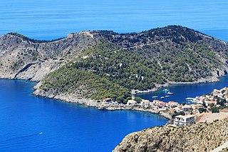
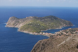
The Assos Castle is a Venetian fortification on Cephalonia island in western Greece.

Argostoli Public Library, also known as Korgialenios Library, is a Greek public library in Argostoli, Kefalonia. The library shares the same building as the Korgialenio History and Folklore Museum.
References
- ↑ "Detailed census results 1991" (PDF). Archived from the original (PDF) on 2016-03-03. (39 MB)(in Greek and French)
38°08′N20°38′E / 38.13°N 20.64°E
| | This Ionian Islands location article is a stub. You can help Wikipedia by expanding it. |