
Ithaca, Ithaki or Ithaka is a Greek island located in the Ionian Sea, off the northeast coast of Kefalonia and to the west of continental Greece.
Kefalonia or Cephalonia, formerly also known as Kefallinia or Kephallenia (Κεφαλληνία), is the largest of the Ionian Islands in western Greece and the 6th largest island in Greece after Crete, Euboea, Lesbos, Rhodes and Chios. It is also a separate regional unit of the Ionian Islands region. It was a former Latin Catholic diocese Kefalonia–Zakynthos (Cefalonia–Zante) and short-lived titular see as just Kefalonia. The capital city of Cephalonia is Argostoli.

Argostoli is a town and a municipality on the island of Kefalonia, Ionian Islands, Greece. Since the 2019 local government reform it is one of the three municipalities on the island. It has been the capital and administrative centre of Kefalonia since 1757, following a population shift down from the old capital of Agios Georgios, also known as Kastro, to take advantage of the trading opportunities provided by the sheltered bay upon which Argostoli sits.

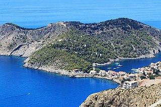
Poros is a picturesque small town located in the municipal unit of Eleios-Pronnoi, some 40 km SE of Argostoli, 28 km SE of Sami and 12 km NE of Skala, in the southeast of Cephalonia, one of the Ionian Islands of Greece.

Mantzavinata is a village in the southwest of Kefalonia island, Greece, where the famous Mantzavino Wine is sold. Mantzavinata is 4 km southwest of Lixouri on the Paliki peninsula. Mantzavinata has three churches and a small square called Lemonata. A wine festival is held each August in Mantzavinata.
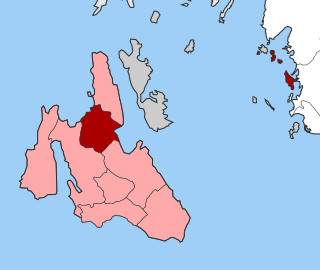
Leivatho is a former municipality on the island of Kefalonia, Ionian Islands, Greece. Since the 2019 local government reform it is part of the municipality Argostoli, of which it is a municipal unit. It lies south of Argostoli, on the central south coast of the island, and has a land area of 62.626 km² and a population of 5,765.

Lixouri is a town and a municipality in the island of Kefalonia, the largest of the Ionian Islands of western Greece. It is the main town on the peninsula of Paliki, and the second largest town in Kefalonia after Argostoli and before Sami. It is located south of Fiskardo and west of Argostoli. Since the 2019 local government reform it is one of the three municipalities on the island. It has one municipal unit that is coterminous with the municipality: Paliki.
Pylaros is a former municipality on the island of Kefalonia, Ionian Islands, Greece. Since the 2019 local government reform it is part of the municipality Sami, of which it is a municipal unit. It is located in the north-central part of the island. It has a land area of 81.112 km² and a population of 1,422 inhabitants. The seat of the municipality and largest town is Agia Effimia.
The Gulf of Argostoli is a gulf of the Ionian Sea on the island of Cephalonia, western Greece. It separates the Paliki peninsula from mainland Cephalonia, and opens toward the Ionian Sea in the south. The gulf is 13 km (8.1 mi) long and 2 to 3 km wide. Lixouri, the second-largest town of Cephalonia, is situated on its western shore, and the capital Argostoli is situated on a bay in the eastern shore. The shores of the gulf are mountainous, especially in the east.

Agios Georgios is a village and a former municipality on the island of Corfu, Ionian Islands, Greece. Since the 2019 local government reform it is part of the municipality North Corfu, of which it is a municipal unit. It is located in the northwestern part of Corfu and has a land area of 39.445 square kilometres and a population of 2,992. The seat of the municipality was the town of Agros.

Esperies is a former municipality on the island of Corfu, Ionian Islands, Greece. Since the 2019 local government reform it is part of the municipality North Corfu, of which it is a municipal unit. It is located in the northwest corner of the island of Corfu. It has a land area of 54.462 square kilometres (21.03 sq mi) and a population of 6,925. The seat of the municipality was the town of Velonades.
Korissia is a former municipality on the island of Corfu, Ionian Islands, Greece. Since the 2019 local government reform it is part of the municipality South Corfu, of which it is a municipal unit. It is in the southern part of the island. It has a land area of 27.675 km2. The seat of the municipality was the town of Argyrades.

Palaiokastritsa is a village in northwestern Corfu, Greece. Corfu has been suggested to be the mythical island of the Phaeacians and the bay of Palaiokastritsa to be the place where Odysseus disembarked and met Nausicaa for the first time. The monastery in Palaiokastritsa, which dates from 1225, houses a museum. It is especially known for its great cliffs and nearby beaches.

Parelioi is a former municipality on the island of Corfu, Ionian Islands, Greece. Since the 2019 local government reform it is part of the municipality Central Corfu and Diapontia Islands, of which it is a municipal unit. It is located on the central west coast of the island of Corfu. It has a land area of 48.990 square kilometres (18.92 sq mi) and a population of 6,751. The seat of the municipality was the town of Kokkini.

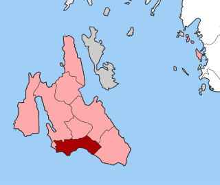
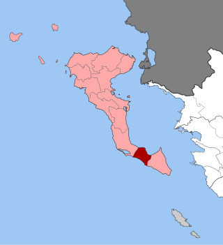
Eleios-Pronnoi is a former municipality on the island of Kefalonia, Ionian Islands, Greece. Since the 2019 local government reform it is part of the municipality Argostoli, of which it is a municipal unit. The municipal unit has an area of 111.687 km2. The seat of the municipality was in Pastra. The municipal unit contains several mountain ranges, including the eastern part of Mount Ainos.

Sami is a town and a municipality on the island of Cephalonia, Ionian Islands, Greece. Since the 2019 local government reform it is one of the three municipalities on the island. It is located on the central east coast of the island. The municipality has an area of 291.2 km2 and the municipal unit has an area of 129.326 km². The 2021 census recorded a population of 2,478 in the municipal unit, and 5,501 in the municipality in its post-2019 extension. Its municipal seat is the town of Sami
Skineas is a village and a community on the Paliki peninsula of Cephalonia, Greece. It is 6 km northwest of Lixouri. The community consists of the villages Skineas and Vlychata.
Agios Dimitrios is a village, about 2 miles (3.2 km) north of Lixouri in the Paliki peninsula of Cephalonia. The village which lies on the hillside just above the gulf of Argostoli and is a five-minute drive along the main road out of Lixouri.
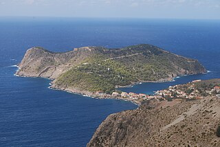
The Assos Castle is a Venetian fortification on Cephalonia island in western Greece.


