Gulf of Argostoli

Last updated

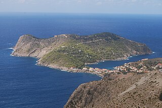
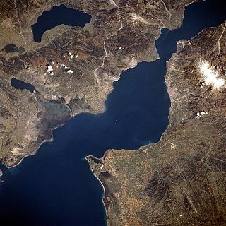
The Gulf of Argostoli (Greek : Κόλπος Αργοστολίου) is a gulf of the Ionian Sea on the island of Cephalonia, western Greece. It separates the Paliki peninsula from mainland Cephalonia, and opens toward the Ionian Sea in the south. The gulf is 13 km (8.1 mi) long (north to south) and 2 to 3 km (1.2 to 1.9 mi) wide. Lixouri, the second-largest town of Cephalonia, is situated on its western shore, and the capital Argostoli is situated on a bay in the eastern shore. The shores of the gulf are mountainous, especially in the east.

Greek language language spoken in Greece, Cyprus and Southern Albania

Greek is an independent branch of the Indo-European family of languages, native to Greece, Cyprus and other parts of the Eastern Mediterranean and the Black Sea. It has the longest documented history of any living Indo-European language, spanning more than 3000 years of written records. Its writing system has been the Greek alphabet for the major part of its history; other systems, such as Linear B and the Cypriot syllabary, were used previously. The alphabet arose from the Phoenician script and was in turn the basis of the Latin, Cyrillic, Armenian, Coptic, Gothic, and many other writing systems.

Bay A recessed, coastal body of water connected to an ocean or lake

A bay is a recessed, coastal body of water that directly connects to a larger main body of water, such as an ocean, a lake, or another bay. A large bay is usually called a gulf, sea, sound, or bight. A cove is a type of smaller bay with a circular inlet and narrow entrance. A fjord is a particularly steep bay shaped by glacial activity.

Ionian Sea Part of the Mediterranean Sea south of the Adriatic Sea

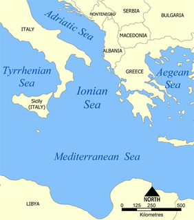
The Ionian Sea is an elongated bay of the Mediterranean Sea, south of the Adriatic Sea. It is bounded by Southern Italy including Calabria, Sicily, and the Salento peninsula to the west, southern Albania to the north, and the west coast of Greece.

The main settlements on the shore of the gulf are, from the southwest and clockwise: Lixouri, Agios Dimitrios, Kouvalata, Kontogourata, Farsa, Drapano and Argostoli. The Gulf of Argostoli is navigable, and the ports of Argostoli and Lixouri are served by ferries. Concerns have risen about the environmental effects of fish farming in the gulf. [1]

Lixouri Place in Greece

Lixouri is the main town on the peninsula of Paliki in the island of Kefalonia, one of the Ionian Islands of western Greece. Lixouri is the second largest community in Kefalonia after Argostoli and before Sami and is the capital of the small peninsula. It is located south of Fiskardo, west of Argostoli.

Agios Dimitrios, Cephalonia Place in Greece

Agios Dimitrios is a village, about 2 miles (3.2 km) north of Lixouri in the Paliki peninsula of Cephalonia. The village which lies on the hillside just above the gulf of Argostoli and is a five-minute drive along the main road out of Lixouri.

Farsa, Greece Place in Greece

Farsa is a village on the island of Kefalonia, Greece, part of the municipal unit of Argostoli. It is situated on the eastern shore of the Gulf of Argostoli. Farsa is 2 km northwest of Davgata, 4 km northeast of Lixouri and 6 km north of Argostoli. Records exist in the Venetian archives for this village since the early Venetian period. During World War II many Italian soldiers were posted there and it was one of the places that the Massacre of the Acqui Division took place. The 1953 Ionian earthquake damaged many buildings in the old village of Farsa but did not totally destroy it. The remains of the old village are visible today. Dr. Nicholas Zaferatos, an environmental studies professor in the Huxley College at Western Washington University has made a study with his students on the renovation of the old village. The entire population that time as well as other parts of the island were homeless and part of the population left Farsa.

Related Research Articles

Cephalonia regional unit in Ionian Islands, Greece

Cephalonia or Kefalonia, formerly also known as Kefallinia or Kephallenia (Κεφαλληνία), is the largest of the Ionian Islands in western Greece and the 6th largest island in Greece after Crete, Evoia, Lesbos, Rhodes, and Chios. It is also a separate regional unit of the Ionian Islands region, and the only municipality of the regional unit. It was also a former Latin Catholic diocese Kefalonia–Zakynthos (Cefalonia–Zante) and short-lived titular see as just Kefalonia.

Gulf of Patras bay

The Gulf of Patras is a branch of the Ionian Sea in Western Greece. On the east, it is closed by the Strait of Rion between capes Rio and Antirrio, near the Rio-Antirrio bridge, that is the entrance of the Gulf of Corinth. On the west, it is bounded by a line from Oxeia island to Cape Araxos. To the north it is bounded by the shore of Aetolia-Acarnania in continental Greece, and to the south by Achaea in the Peloponnese peninsula. It is 40–50 km long, 10–20 km wide, and has an area of 350–400 km2.

Vlachata Place in Greece

Vlachata is a village and a community in the eastern part of the municipal unit of Leivatho near the south coast of the island of Kefalonia, Greece. To avoid confusion with another Vlachata near Sami, it is also known as Vlachata Eikosimias. The community consists of the villages Vlachata and Simotata, which is 2 km east of Vlachata. Vlachata is situated on a mountain slope above the Ionian Sea coast, at about 200 m elevation. Mount Ainos, the highest point of Cephalonia, is 4 km to the northeast. Vlachata is 1 km northwest of Lourdata, 2 km southeast of Mousata, 13 km southwest of Poros and 13 km southeast of Argostoli. The road from Argostoli to Poros runs through Vlachata. Vlachata suffered great damage from the 1953 Ionian earthquake.

Svoronata is a village in the municipal unit Leivatho, southern Cephalonia, Greece. It is situated on a hillside near the Ionian Sea coast. It is 2 km west of Metaxata, 2 km east of the Cephalonia International Airport and 7 km southeast of Argostoli.

Moussata Place in Greece

Mousata is a village in the municipal unit of Leivatho on the island of Cephalonia, Greece. It is situated between Mount Ainos and the Ionian Sea, at about 200 m elevation. It is 2 km northwest of Vlachata, 4 km east of Peratata and 12 km southeast of Argostoli. The road from Poros to Argostoli passes through the village. Mousata suffered great damage from the 1953 Ionian earthquake.

Ambracian Gulf bay

The Ambracian Gulf, also known as the Gulf of Arta or the Gulf of Actium, and in some official documents as the Amvrakikos Gulf, is a gulf of the Ionian Sea in northwestern Greece. About 40 km (25 mi) long and 15 km (9 mi) wide, it is one of the largest enclosed gulfs in Greece. The towns of Preveza, Amphilochia, and Vonitsa lie on its shores.

Peratata Place in Greece

Peratata is a village and a community in the municipal unit of Leivatho, in the southern part of the island of Cephalonia, Greece. It is situated at the foot of a hill, which is crowned by the Agios Georgios fortress. The community consists of the villages Peratata and Kastro. The western part of Peratata is referred to as Travliata. Peratata is 2 km north of Kerameies, 3 km south of Troianata, 8 km southeast of Argostoli and 19 km west of Poros. The road from Argostoli to Poros and Skala passes through the village.

Troianata Place in Greece

Troianata is a village and a community in the municipal unit of Argostoli, on the island of Cephalonia, Greece. The community consists of the villages Troianata, Demoutsantata and Mitakata. Troianata is situated on a hillside, at about 300 m elevation. It is 3 km north of Peratata, 3 km southwest of Valsamata and 6 km southeast of Argostoli. Troianata suffered great damage from the 1953 Ionian earthquake.

Paliki Place in Greece

Paliki is a peninsula and a former municipality on the island of Kefalonia, Ionian Islands, Greece. Since the 2011 local government reform it is part of the municipality Kefalonia, of which it is a municipal unit. The municipal unit has an area of 119.341 km2. The name comes from the ancient town of Pale/Pali, which was north of Lixouri and is now an archaeological site. The peninsula is the westernmost part of Kefalonia. The seat of the municipality was the town Lixouri (3.752).

Faraklata Place in Greece

Faraklata is a village and a community in the municipal unit of Argostoli, Cephalonia, Greece. It is situated on a mountain slope above the eastern shore of the Gulf of Argostoli, at about 220 m elevation. Faraklata is 2 km south of Dilinata, 4 km northeast of Argostoli and 7 km northwest of Valsamata. The community consists of the villages Faraklata, Razata, Drapano and Prokopata. There is a small cave east of the village. Faraklata suffered great damage from the 1953 Ionian earthquake.

Dilinata Place in Greece

Dilinata is a village in the municipal unit of Argostoli, Cephalonia, Greece. It is situated on a mountain slope, at 400 m elevation. It is 2 km east of Davgata, 2 km north of Faraklata and 6 km northeast of Argostoli. The mountaintop of Evmorfia, elevation 1,043 m, is to the northeast. Dilinata suffered great damage from the 1953 Ionian earthquake.

Davgata Place in Greece

Davgata is a village in the island of Cephalonia, Greece. It is part of the municipal unit of Argostoli. It is situated on a mountain slope above the eastern shore of the Gulf of Argostoli, at about 300 m elevation. Davgata is 2 km southeast of Farsa, 2 km west of Dilinata and 5 km north of Argostoli. Davgata has a Museum of Natural History, opened in 1996. The mountaintop of Evmorfia, elevation 1,043 m, lies to the northeast. Davgata was severely damaged by the 1953 Ionian earthquake.

Myrtos Gulf

The Myrtos Gulf is a gulf on the north coast of the island Cephalonia, Greece. It is a bay of the Ionian Sea. The main villages on its shore are Asos and Zola. The total length is approximately 10 km long and is approximately 10 km wide. It stretches from Cape Kakata to Asos from east to west and from Zola to the Asos Peninsula to the north. The gulf has a mountainous coast. There are no ferry routes in this gulf.

Cephalonia Prefecture Former prefecture in Ionian Islands, Greece

The Cephalonia Prefecture was a prefecture in Greece, containing the Ionian islands of Cephalonia and Ithaca. In 2011 the prefectural self-government was abolished and the territory is now covered by the regional units of Cephalonia and Ithaca.

Geography of Greece

Greece is a country in Southern Europe, bordered to the north by Albania, North Macedonia and Bulgaria; to the east by Turkey, and is surrounded to the east by the Aegean Sea, to the south by the Cretan and the Libyan Seas, and to the west by the Ionian Sea which separates Greece from Italy.

Agios Nikolaos is a village in the municipal unit of Eleios-Pronnoi on the island Cephalonia, Greece. Its population is 96 people. It is situated in an inland valley, at 280 m elevation. It is 3 km southeast of Digaleto, 4 km north of Xenopoulo, 6 km northwest of Poros and 20 km east of Argostoli. The road from Poros to Sami passes through the village. Agios Nikolaos suffered great damage from the 1953 Ionian earthquake. The village has an elementary school and a church named Saint Nicholas.

References

Coordinates: 38°10′N20°27′E / 38.167°N 20.450°E / 38.167; 20.450

Geographic coordinate system Coordinate system

A geographic coordinate system is a coordinate system that enables every location on Earth to be specified by a set of numbers, letters or symbols. The coordinates are often chosen such that one of the numbers represents a vertical position and two or three of the numbers represent a horizontal position; alternatively, a geographic position may be expressed in a combined three-dimensional Cartesian vector. A common choice of coordinates is latitude, longitude and elevation. To specify a location on a plane requires a map projection.