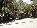
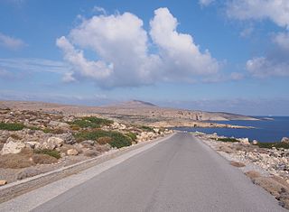
A view to the west up the valley. The access road is on the left. The region of Vai Villa is out of sight over the pass ahead, in the agricultural land of Toplou Monastery.
Vai or more accurately Vaï (Greek: Βάι),[lower-roman 2] Greek for "palm",[2][lower-roman 3] is a region of east Crete between Cape Sidero and Cape Plaka, just south of the site of ancient Itanus but north of the villages that surround and are part of Palaikastro. Vai does not belong to them nor is it part of any civic unit of the local civic division of Greece. It is not itself an official village.[lower-roman 4] The region is somewhat isolated on the isolated northeast peninsula, connecting only to Eparchos odos moni Toplou, the only road between Palaikastro and Toplou Monastery.[lower-roman 5] The entire distance is essentially trackless and deserted, as the name of one of the beaches at Itanus suggests, Eremoupolis, "deserted city".
Vai is a protected area under the jurisdiction of the national government. It has been defined as different kinds of parkland by different governmental agencies. Vai Palm Forest, or more officially Vai Aesthetic Forest,[3] contains several thousand palm trees in a valley perpendicular to the beach and running down to it. Before being protected, the forest was used as an ad hoc campground by a large transient population frequenting the beach. In the late 20th century, to protect it, the forest was declared a national park and was surrounded by a barbed-wire fence.[4]
Vai beach is popular but crowded. Staying on the beach overnight is not allowed. Some daytime facilities are collected in a building center behind the beach, and there is a parking lot. A few restaurants have taken advantage of the road. Palms extend across the back of the beach. In front of them are rows of quasi-permanent shelters from the sun, which vary from decade to decade: umbrellas at one time, tents at another, thatched roofs at another. Overnight visitors are expected to find lodging and necessities in the villages surrounding Palaikastro to the south, a few minutes away. To the north is the deserted city of Itanos, which, however, has some camping and two beaches. Itanos beach as well as Psili Ammos beach to the south have been clothing optional. North of Eremoupolis beach, the shoreline becomes rugged and cliff-lined, and the country desert.
The next most general park system imposed on Vai is the Natura 2000 protected areas mandated by the European Union in conjunction with the government of Greece. The abandoned land on the Itanos peninsula of Cape Sidero, from which the national park had been created by eminent domain, is a refugium (biological "refuge") for indigenous plant and animal species, many rare or endangered, as well as a station of the migration routes for a large number of migratory birds. The ecology needs to be protected.
Coincidentally the entire area had come under archaeological scrutiny by a collaboration of archaeological organizations, such as the French School at Athens, which had been conducting excavations on ancient Itanus, just to the north of Vai, and had also discovered the Minoan villa. The resulting Itanos Archaeological Survey conducted during the period 1994-2005 had located roughly 100-200 sites covering occupation of the cape since the Neolithic.[5] The government therefore declared two new Natura 2000 protected areas in northeast Crete, GR4320006 authorized under the Habitats Directive for protection of the species,[1] and GR4320009 for protecting sites of community importance.[6]
Between them the two Natura 2000 areas account for the entire NE peninsula[7] from and including Cape Plaka, but not as far west as Siteia, all of Cape Sidero and the offshore islands, and most of the survey territory. In 2015 a third level of park was applied, the Sitia UNESCO Global Geopark, protecting the geological formations of all of east Crete.
Except for Palaikastro and the surrounding villages, the region had no official settlements, the reason being that until after WWII the land except for Palaikastro was owned by Toplou Monastery. In the disputes over the land in the late 20th and early 21st centuries, the land was regarded as real estate, a form of property. The owner of land should have the use of it and should be able to dispose of it. When the government took possession of the tip of Cape Sidero and built a military base there, it denied the use of the land to the monastery, and yet maintained the monastery's ownership of the land. The Greek Archaeological Service similarly took possession of the archaeological sites, and the National Forest Service of the palm forest, and yet the fiction was maintained that the monastery owned the land. What rights that ownership entailed finally became a matter for the courts.
These developments left the 2011 municipal planners with the problem of how to treat the former monastic lands. Except for creating the settlement of Toplou to contain the monastery and its industry, and the settlement of Kyriamadi for the base, they did nothing. The monastery still owns farms and businesses in the area. It can't do anything contrary to the dictates of the parkland, which is administered as a Natura 2000 protected area, and yet it otherwise owns the land and retains the rights of owners. Restaurants and other businesses along the road give their addresses as a number, the name of the road, and "Toplou," "Palaikastro," or "Siteia," all in the Toplou hierarchy.
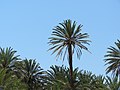
Vai aesthetic forest
Wetlands of the lower forest
The discovery of theophrasti
Vai palm forest is named for Phoenix theophrasti, one of 14 species of the genus Phoenix, etymologically another ancient Greek word for "palm." The botanical palms are the Arecaceae family, flowering, evergreen perennials containing a spirally arranged cluster of fronds branching from the top of an otherwise unbranching stem, a configuration readily identifiable to anyone ancient or modern as a "palm tree."
There are five subfamilies, that of Phoenix being the Coryphoideae, most of which have palmate leaves ("hand-like"). Of its 8 tribes, the Phoeniceae contains only one genus, Phoenix, which, exceptionally to the Coryphoideae, have pinnate leaves ("feather-like"). Palms bear a wide variety of nut-like fruits. Phoenix, however, bears dates, which are soft, oily, sweet nuts. The "date palm," dactylifera, is the species of date cultivation.[8] The name is often followed by an L., meaning the classification is of Linnaeus. The other species do not bear fruits sufficiently large and sugary to be edible, but hybrids between them and P. dactylifera L. are cultivated.
Until 1967 the Vai palms were taken to be "an escaped cultivar of the Date Palm...."[9] In that year Werner Greuter noticed certain differences and presented the Vai palm as a different species, which he named theophrasti after Theophrastus, the botanist at Aristotle's school at Athens, the Lyceum, which he inherited on the exile and death of Aristotle. In Peri Phytōn Historias[lower-roman 6] he uses Phoenix to refer, not just to P. dactylifera, but to any palm whatsoever, as had Aristotle before him in his own Peri Phyton.[lower-roman 7][10]
In those days, botany was already an old and mainly foreign topic, with plant lore arriving from all over the known world. The Lyceum kept a botanical garden (to go along with the zoo). They sent science officers with Alexander to collect specimens.[lower-roman 8] There is a strong case from comparative philology that that "Phoinix" came from the Egyptian word for date-palm, bnrt.[11][lower-roman 9] In a second point of view, the source of Phoinix is a variant of brnt, namely bni, meaning "date."[12][lower-roman 10]
These peripatetics, as they were called,[lower-roman 11] were the closest persons the ancient Greeks had to scientists, because of their insistence on theorizing from data actually investigated.[lower-roman 12] Their method was to apply the new logic Aristotle had devised for the classification of data and the art of definition, which is the ancestor of modern biological uses. The gist of classification was to find objects under the same universal and divide them into subtypes. One defined any subtype (eidos, species) by stating its type (genos, genus) and the difference that distinguished the subtype.
A species might also be a genus with subtypes of its own. This logical telescope failed at either end.[lower-roman 13] At the bottom one might expect to find exactly identical individuals purely of one type, but none such can be found. Every individual of the type differs in some way. The answer to this conundrum was the essence, which was that part of the species that did not vary. Variation was caused by different "accidents," such as shape, size, etc., which were "in" the substance.[lower-roman 14]
One did not go very far down the hierarchy without encountering a bewildering maze of variants. The essence is indiscernable directly, but not indirectly. The accidents are the clothes, so to speak, worn by the essence. Through the persistence and associations of the accidents the viewer comprehends a unity behind them, which may be hard to define. The easiest course is to use the persistent accidents as differences, which botanists and zoologists have had to do.[lower-roman 15] Linnaeus kept the system, but added standard levels of type and insisted on public authorization of the resulting names.
The peripatetic plant (phyton, etymologically “growth”) is defined as a non-sensitive, animate substance, which transmuted into the kingdom of plants is still credible. Sensitivity, today accounted for by the nervous system, belongs to animals. There is, however, no mention of chlorophyll, the essential ingredient of plants, nor does the color, green, play any role.[lower-roman 16] Both Aristotle and Theophrastus subdivide plants into trees, shrubs, and herbs, though Theophrastus adds underbrush. These are not currently taxons, but modern botany still defines them as descriptive types.[lower-roman 17] Theophrastus’ definition of palm is a common point between ancient and modern: “The date-palm too bears at the top … but this tree also has its leaves and shoots at the top.”[13] His palm was at the logical level of the modern family.
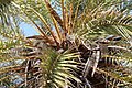
P. theophrasti, single stem
View at the top of the stem showing the spines on the lower fronds
Genista acanthoclada
Clumps of 3-stem palms
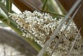
Male palm showing the flowers among the lower fronds
Female palm showing the upright fruit among the lower fronds
Recovery of the forest
Fenced in forest. Some of the trees have escaped to the other side of the road.
Although the forest was declared a national park in 1987 and was fenced, which probably saved it from destruction by 200,000 or more visitors per year, no effort was made to recover it until Project Vai staged by the European Commission 1999-2002 in compliance with the Habitats Directive of Natura 2000. The forest had been in no danger prior to 1957, consisting of 300ha (740 acres). In that year a massive agricultural project staged by the monastery uprooted most of the forest, reducing it to 12ha (30 acres). That slowly increased to 15.6ha (39 acres) with a few thousand trees.
The Management Plan put into effect by the government as part of Natura 2000 recovered a core forest, today carefully protected. Negotiation with the agents of the monastery acquired additional acreage, though not in the quantity requested. The monastery was included in the caretaker administration. Today the forest is 20ha (49 acres). The extra acres were replanted. Monitoring of the water table, with an irrigation system to control it if necessary began. The health of the plants is checked. Everything is done to insure regeneration. A public awareness campaign was staged. In addition to the monastery, the Forest Directorate of Lasithi and the Goulandris Natural History Museum were made caretakers.[14]
Vai coastal features
Two of the three valleys at Vai seen from on top the headland between Vai and Psili Ammos beaches. The parking lot is to the left. On the entrance road coming down beside the forest on the right can be seen a line of automobiles waiting to enter the lot.
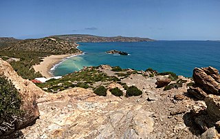
Northeastern Crete is characterized geologically by a coastal range of hills followed inland by a relatively flat plain, followed further inland by a higher range. The coastal hills alternate with coastal valleys that have eroded into the sea perpendicular to the coastline so as to form headlands alternating with beaches behind which are valleys that may or may not have penetrated into or beyond the plain. The Vai area has three of these. On the south is Psili Ammos beach, which penetrates about 318m (348yd) between its headlands and is about 40m (44yd) wide, consisting of the "fine sand" for which it is named. The next valley up has been utilized for the Vai beach parking lot, which is about 120m (130yd) by 43m (47yd) and is surrounded on all sides but one by precipitous rocky slopes. Trails lead to viewpoints from the top.
The next valley north contains the forest. It reaches all the way through the coastal range and is apparent in the highlands beyond it. There are no palms there, however. Whatever connection once existed across the plain has been obliterated by agricultural use. Vai Farm, owned by the monastery, is there. The main road north cuts across the mouth of the coastal valley. A dirt farm road runs parallel to the main road one field further to the coast, forming the border to the forest, which appears cut off there on the maps.
The valley in which the forest exists drops from about 9m (30ft) to 0 at the waterline. Within it an intermittent stream emerges from the northern hill and flows down to a wetlands, providing just the amount of water required for the trees.
Peristerovrachoi, or "pigeon rocks," is a group of islets off the north headland of Vai beach.
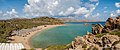
Vai beach
Looking north along the beach through the sun shelters.South end of the beach, showing the restaurant and the heights leading to Psili Ammos.
Vai beach is accessed by an east-west side road from the main north-south road, Eparchos odos moni Toplou. About 1km (0.62mi) of good, paved road runs along the south side of the forest from which it is separated by a barbed-wire fence. The heights of the coastal hills loom on either side. Near the beach the road turns to the south to enter the parking lot, which is totally enclosed by the hills. The inland side of the beach still has an open palm forest. Walkways lead to the beach, which is totally enclosed by a headland of 47m (154ft) to the north and a headland of 10m (33ft) to the south. The forest is on the northern part of the beach, where a stream enters the sea, deriving from the northern hill. A restaurant and other buildings have been built up on the slope of the south hill, where also a managed trail leads over the heights to Psili Ammos beach. An array of sun shelters covers the southern part of the beach. These are for rent.
On a typical day the visitor braves the line of traffic to the beach, pays the admission fee, parks in the lot, pays for a lounge chair with cover, and enjoys the beach, dining at the restaurant and using the rest room facilities. For more privacy the visitor can climb over the trail to Psili Ammos. Itanos beach is not accessible from Vai, but is reached by its own access road a little further north. At the end of the day the beach must be vacated. The forest is always off-limits.
Psili Ammos beach
Psili Ammos beach is named for its "fine sand." A number of beaches have this name throughout the coasts of the Aegean. This one of Crete is located in a ravine on the south side of the southern headland of Vai beach. A specially constructed trail leads over the headland to the beach, which is valued for its privacy and natural beauty. There are no facilities in it; necessities must be carried in.
Gallery
Panorama of Vai beach from the southern headland showing the roof of the restaurant, the sun shelters, the northern headland and pigeon rocks.
The palm forest remaining at the back of the beach, not actually in the national park. Boardwalks facilitate walking over the sand.
Coast near Vai from the southern headland. Visible is the northern headland, pigeon rocks off its coast, and Cape Sidero in the distance.
Pigeon rocks from the shore.
Psili ammos from the south headland of Vai beach.
Parking lot, Vai beach.
Vai villa
In 1950 excavators from the French School at Athens, who were there to excavate Itanus looking for Minoan remains, did not find any within the walls of Itanus, but did find some to the south, on a hill in what was at the time Vai Palm Forest. They did some excavating and drew some plans, concluding finally that the remains were a substantial residence of the Late Minoan period, which they dubbed Vai Villa. In 1957 the forest was uprooted in favor of Vai Farm, but the villa survived.
Returning in 1994-2005 the French School in collaboration with other agencies conducted the Itanos Archaeological Survey on the northeast peninsula north of Vai. Dividing it into zones, they termed the southernmost zone Vai. All the sites they found were numbered sequentially. A site was identified by the zone name and the sequence number. Vai zone had 14 sites, of which 5 contained surface evidence (sherds) dating it to the Late Minoan Period. The villa was assigned the identifier Vai 69.[15] Informally it was sometimes called Metochi Vai after the tavern constructed by the monastery near it.[lower-roman 18] The others, Vai 161,[16] 60,[17] 29[18] and 28,[19] were isolated buildings, except for Vai 161, which was a dam system for impounding a reservoir, and Vai 28, a circular funerary structure. These were all located in the highland south of Vai, except for the villa. In two, the Minoan layer was overlain by Greco-Roman layers. The other 9 of the 15 were entirely Greco-Roman, from which one might suppose, assuming data representative of the original populations, that the Minoans were lightly settled in that area, but the later Greeks more heavily. There was a gap representing the Dark Age.
The most extensive site, the villa, was to suffer bad fortune. Toplou Monastery, owner of the farm, the tavern, and the real estate at Vai, had decided to support its development as a recreational area. A parking lot for the buses ferrying future tourists would be put in place. The contractors got as far as bulldozing a strip before being enjoined to cease and desist. However, the careless operators had moved in on the villa and altered it to such a degree that the plans of 1950 no longer describe it.[15] Those plans remain, but they can't be verified, which may well be the case of other settlements of the survey in the future.
The original plan shows a partial foundation of 6 rooms arranged in two wings meeting in a concave corner seen from outside the house.[20] The long dimension is 13.33m (43.7ft) and the short is 8m (26ft), with the long oriented to 320°. The area required by the walls is 106.64m2 (1,147.9sqft), but this is not the area of the house. Assuming that the long dimension might be the side of a square would obtain 177.69m2 (1,912.6sqft) as a minimum area for the house, but long dimension is not terminated on the southern side by an exterior wall, so the house was wider.
The exterior wall is fairly thick, 0.7m (2.3ft) to 0.8m (2.6ft), constructed from rough-hewn limestone blocks, local proveniance. An upper floor was probably supported, which is further evidenced by a possible stairwell. The two interior rooms in the SE wing were too small for habitation: only 1.33m (4.4ft) and 1.67m (5.5ft) wide. They contained green schist paving stones forming a ramp on the rising ground, and were interpreted as risers that had fallen into the space below the staircase. Today not even the internal rooms are visible, and the schist has disappeared. The fact that the staircase is in a different wing suggests an add-on staircase similar to those in Minoan houses at Palaikastro. There the upper floors were used for ritual purposes.
The minimum possible area of two equal floors (but the house may have been split-level) might have been roughly 4000 square feet, not large enough for a Minoan public building (which were huge) but too large for a single humble family, hence the conclusion of the excavators that it was "an isolated private house," probably the villa of a substantial country farmer.
At the time of discovery, the excavators reported a dense brushwood in the vicinity. This would have been the larger palm forest before it was demolished. Still, the farmland of the villa could have been further out in the valley, perhaps even the distant ancestor of Vai farm. The house was located on the slope of a hill at the edge of the coastal hill zone.
Contention over the future of the cape
Toplou Monastery has a long tradition of proactivity in business and politics. They slowly built up land ownership on the cape and did not hesitate to start businesses on it to provide themselves with an operating budget. They built windmills, started a farm (Vai Farm), and maintained fields and facilities to manufacture wine and olive oil. With the proceeds they had the money for charitability, operating a free school for the local inhabitants, and maintaining a hostel, dining facility, museum, and whatever else seemed most appropriate.
As the post-war decades rolled on, their orientation changed from primarily caretaker to primarily business. They began making decisions that were highly profitable but disastrous to the environment and cultural sites, such as clearing out the majority of Vai palm forest in favor of arable cropland. These decisions came to the attention of a new generation of scientists and responsible governmentalists, whose first reaction was to sequester monastery land by turning it into parkland. From this sequestration an issue arose over whose land it really was, and whether the owner could dispose of it as he pleases, in conformance with the legal concept of property.
The monastery brought the case to a final test by leasing land to a British development corporation, Minoan Group. They were interested in capitalizing on the recreational value of the cape, planning to build hotels, a golf course, and various other recreational facilities. They started in the Vai area. Having obtained the licenses they required from local government, they began work in 2006, bulldozing parts of Vai farm to create a parking lot to which they planned to bus large numbers of tourists. The monastery would receive a percentage of the profits.
Opinion in Crete and elsewhere now became polarized. Some people believed that development of otherwise fallow land for recreational and business purposes was a good thing. They had the weight of the famous monastery behind them. Others wished to conserve the rare species, unusual terrain, and extensive archaeological sites intact. They had the scientists behind them. A general protest and lawsuit was brought by the citizenry in the Cavo Sidero dispute, which ended in the Supreme Administrative Court. In 2008 The court found in favor of the plaintiffs on the grounds that the developers had failed to investigate the ecological impact adequately. Work on the project was halted.[21]
The first match of the contest for profitability had been lost, but all was not lost. Minoan Group emended their plan, submitting a scaled-down version that emphasized water sports rather than land sports, which they called Itanos Gaia. In opposition, the archaeologists, Oliver Rackham and Jennifer Moody, obtained a petition with 11,000 signatures from persons in many countries, asking for a remission against the threat to the countryside.[22]
In short, the petition did not achieve the winning acceptance. A presidential decree of July 3, 2016, approved Itanos Gaia, and was followed immediately by a request for an annulment on the grounds that the project would degrade the environment and quality of life in Lasithi, and for a number of technicalities the decree was actually illegal. In 2017 the Supreme Court rejected the request, siding with the legality of the decree, and bringing up some technicalities of its own, such as that the applicants had not proved they were residents of Lasithi.[23] The Minoan Group was now free to proceed. Having gone heavily into debt it could not proceed without an inflow of fresh money. Most recently (2022) it has been advertising for new investors.[24] If it cannot obtain them the project will be a bubble, a large-scale financial disaster. If it can obtain them, conservation of the cape will enter a new phase.
Notes
↑ The coordinates of survey sites are not being released for publication, but VAI 69 is described as being within sight of the inn.
↑ The diaeresis, a double dot, whether in Greek or English, indicates the a and the i are distinct sounds, rather than a combination. Nuances such as this count in etymologizing.
↑ The word is considered a loan from Coptic (ancient Egyptian) bai through the medium of the Greco-Egyptian culture of Alexandria, whose dependency hellenistic Itanos, owner of Vai, was. El-Kady 2009, p.20 "The Coptic word for the palm branch is ba or bai usually used specifically for the midrib of the frond, which is derived from the Egyptian ... ba."
↑ The term "Vai village" is sometimes used of a real estate development and supporting businesses, but these are privately owned and are not a named public domain of their own.
↑ The same road heads to the south along the coast and also joins the monastery to Siteia. East of the monastery it divides, the branch being the road that runs out on Cape Sidero to the military base.
↑ This was the origin of the expedition scientist. Linnaeus sent them out, They accompanied the French in Egypt, and Charles Darwin was one.
↑ In this etymology Phoinix would originally have been "palm country," and the "purple" color from the murex dye vended by the Phoenicians, "palm country people." Po-ni-ke-a appears in the Bronze-Age script, Linear B, meaning a color, probably red. Billigmeier, J.-Chr (1977). "Origin of the Greek Word Phoinix"(PDF). Talanta. VIII–IX.
↑ Phoenicia would have been "the land of dates," and the color, the "color of dates."
↑ So-called from their delivering lectures while "walking around" the grounds of the Lyceum.
↑ The contemporary school at Athens, the Academy, managed by Plato, emphasized analytical study of the type surviving in the Socratic dialogues. The peripatetics were in a sense break-away academics, as they had attended the Academy for some years before going with Aristotle's school.
↑ At the top there are no different types of being, as their differences would have to be non-being, or nothing. Aristotle's top category was therefore substance.
↑ Aristotle profered 10 categories, substance and 9 of accident.
↑ For example, anyone can readily and immediately perceive a palm through the pattern and synchronized actions of its accidents. To define a palm, one must resort to citing those accidents as differences.
↑ There was no Greek theoretical chemistry, even what is today elementary. Chemical reactions were unknown. The most obvious, fire, was thought a substance.
↑ There is also a housing complex of that name elsewhere theoretically consisting of remodelled shepherds' huts. the shepherds supposedly working for the monastery.
↑ IUCN 1987, p.121 "Under the 1937 law national park administration was to be placed under the Forest Service of the Ministry of Agriculture. The responsibility for national parks and nature reserves was given to the Section of National Parks and Aesthetic Forests (later renamed the National Park Department (1983) but the name had reverted to the original by 1985"
↑ Bernal, M. (2006). "Chapter 15: Some Egyptian and Semitic Semantic Clusters in Greek". Black Athena: Afroasiatic Roots of Classical Civilization. Vol.III: The Linguistic Evidence. New Jersey: Rutgers University Press. pp.347–349.
↑ Theophrastus, pp.98–99, I.xiv.2. harvnb error: no target: CITEREFTheophrastus (help)
Rackham, Oliver; Moody, Jennifer (2012). "4.3 Drivers of Change and the Landscape History of Cavo Sidero". In Papayannis, Thymio; Howard, Peter (eds.). Reclaiming the Greek Landscape(PDF). Athens: Mediterranean Institute for Nature and Anthropos (Med-INA).
Theophrastus (1916). An Enquiry into plants. The Loeb Classical Library. Vol.I. Translated by Arthur Hort.
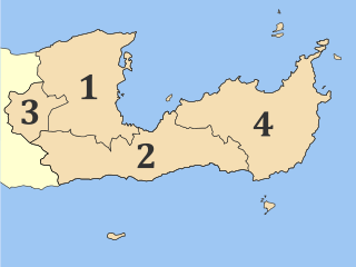
Crete is the largest and most populous of the Greek islands, the 88th largest island in the world and the fifth largest island in the Mediterranean Sea, after Sicily, Sardinia, Cyprus, and Corsica. Crete is located about 100 km (62 mi) south of the Peloponnese, and about 300 km (190 mi) southwest of Anatolia. Crete has an area of 8,450 km2 (3,260 sq mi) and a coastline of 1,046 km (650 mi). It bounds the southern border of the Aegean Sea, with the Sea of Crete to the north and the Libyan Sea to the south. Crete covers 260 km from west to east but is narrow from north to south, spanning three longitudes but only half a latitude.
Lasithi is the easternmost regional unit on the island of Crete, to the east of Heraklion. Its capital is Agios Nikolaos, the other major towns being Ierapetra and Sitia. The mountains include the Dikti in the west and the Thrypti in the east. The Sea of Crete lies to the north and the Libyan Sea to the south.
Sitia or Siteia is a port town and a municipality in Lasithi, Crete, Greece. The town has 11,166 inhabitants and the municipality has 20,438 (2021). It lies east of Agios Nikolaos and northeast of Ierapetra. Sitia's port is on the Sea of Crete, part of the Aegean Sea and is one of the economic centers of the Lasithi region. European route E75 starts in Sitia. Sitia is served by the Sitia Public Airport. Sitia has not experienced the effects of mass tourism even though there is a long beach along the road leading to Vai and several places of historical interest.
Palaikastro or Palekastro, with the Godart and Olivier abbreviation PK, is a thriving town, geographic heir to a long line of settlements extending back into prehistoric times, at the east end of the Mediterranean island Crete. The Kallikratis Programme implemented starting 2011 made the town into a local community under jurisdiction of the next-highest levels, chained as follows: municipal unit Itanos, municipality (demos) Sitia, regional unit Lasithi, region (periphereia) Crete.
Goúves is a village and former municipality in the Heraklion regional unit, Crete, Greece. Since 2011, local government reform it is a part of the municipality Hersonissos, of which it is a municipal unit. The municipal unit has an area of 94.963 km2 (36.665 sq mi). It lies about 9 mi (14 km) east of Heraklion.
Phoenix theophrasti, the Cretan date palm, is a palm native to the eastern Mediterranean, in Greece and Turkey. It, along with Chamaerops humilis are the only native palm species in the Mediterranean basin; areas forested with these species constitute Europe's only palm forests. Similarly in Turkey, it is the only native palm species; all other species—although much more common—are introduced.
Itanos is a municipal unit of the municipality (demos) Siteia in the Lasithi regional unit, eastern Crete, Greece. A former municipality itself, it was included in Siteia as part of the 2011 local government reform. The municipal unit has an area of 197.406 km2 (76.219 sq mi). The population was 2,014 in 2021.
Makry Gialos is a former municipality in Lasithi, Crete, Greece, with a population 2,589 in 2021. It is located on the south-east coast of Crete. Since the 2011 local government reform it is part of the municipality Ierapetra, of which it is a municipal unit. The municipal unit has an area of 75.376 km2 (29.103 sq mi). The seat of the municipality was in Koutsouras, 22 kilometers east of Ierapetra. It was established in 1997 when the communities of Stavrochori, Chrysopigi, Lithines, Schinokapsala, Agios Stefanos, Oreino, Perivolakia and Pefkoi amalgamated into one municipality (Δήμος). In November 2011 the four communities Chrysopigi, Lithines, Perivolakia and Pefkoi passed to the municipality Siteia.
Karydi, officially Καρύδιον (Σητείας), is a village in the highlands of east Crete, Greece, part of the municipal unit Itanos. Under the Kallikratis Programme of 2011 it was made a local community. Its chain of civic jurisdiction is as follows: municipal unit Itanos, municipality (demos) Sitia, regional unit Lasithi, region (periphereia) Crete.
Preveli is a location on the south coast of the Greek island of Crete, in the Rethymno regional unit, notable for its monastery.
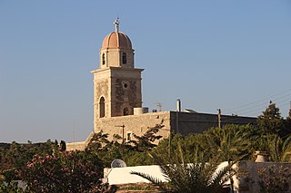
Toplou Monastery is a currently active monastery located in a semi-arid area of the Lasithi regional unit, on the eastern part of the island of Crete in Greece. It is about 6 km (3.7 mi) north of Palekastro and 85 km (53 mi) east of Agios Nikolaos. It is at the base of the Itanos promontory from which Cape Sidero, the easternmost point of Crete, projects to the northeast. The nearest settlements are Sitia to the west and Palaikastro to the southeast; otherwise, the entire promontory is uninhabited except for the modern military reservation at the tip of the cape. In the political structure of Greece, the monastery has been assigned the settlement (oikismos) of Toplou, which it had before 2011, but was validated again in the redivision of 2011. The full civic classification beyond Toplou from 2011 in ascending order is: local community Palaikastro, municipal unit Itanos, municipality (demos) Siteia, regional unit Lasithi, region (periphereia) Crete.
Itanus or Itanos was a Greek city and port on the northeast coast of ancient Crete, on the promontory which the Romans called Itanum, the neuter form of Itanus, Latin for Greek Itanos. The base of the tripartite northeast promontory, today called Cape Sideros, is still called Itanos or Itano in modern Greek.
The Dionysades is a small, northward-trending archipelago off the north coast of the island of Crete, mid-way between the Cape Sidero lighthouse to the southeast ; and Sitia to the southwest. Although the island group is uninhabited, it administratively falls within the Sitia municipal unit of the Lasithi Region, Crete Regional Administration. The group includes the islands of Dragonada, Gianysada, Paximadaki, and Paximada.
Sideros, is the outermost of a chain of two island-like peninsulas forming, with Itanos promontory, Cape Sidero. They are all three the summits of submarine elevations connected by rocky surface cols on which a road has been constructed to Cape Sidero Lighthouse, the elevated facsimile chapel of Saint Isidore, and Port Joannis, a cove of 2 fathoms (12 ft). There are ruins of an ancient temple of Athena destroyed by a tsunami and facilities of the Kyriamadi Naval Station. Kyriamadi is the other island-like peninsula in the chain. Administratively the cape lies within the Itanos municipal unit, Sitia Municipality, Lasithi regional unit, and Crete region.
Theophrastus's Enquiry into Plants or Historia Plantarum was, along with his mentor Aristotle's History of Animals, Pliny the Elder's Natural History and Dioscorides's De materia medica, one of the most important books of natural history written in ancient times, and like them it was influential in the Renaissance. Theophrastus looks at plant structure, reproduction and growth; the varieties of plant around the world; wood; wild and cultivated plants; and their uses. Book 9 in particular, on the medicinal uses of plants, is one of the first herbals, describing juices, gums and resins extracted from plants, and how to gather them.
Cape Sideros or Cape Sidero is a cape at the eastern end of the island of Crete, Greece. Anciently it was known as Samonium or Samonion, Sammonium or Sammonion, Salmonium or Salmonion (Σαλμώνιον) and Salmone (Σαλμώνη). The cape shares the name Sideros or Sidero with the island-like peninsula of which it is a projection, but which had the name first remains unknown, as does the provenance of either name. Cape Sidero is often not confined to the peninsula Sideros, but might refer to the entire northeast promontory.
Preveli Beach is a beach located on the south coast of the Greek Mediterranean island of Crete. It is located in the municipality of Agios Vasilios in the Rethymno regional unit, not far from the Moni Preveli monastery, whose name has passed on to it. According to local legend, the king of Ithaca, Odysseus, remained in the wider area of Lake Preveli after the end of the Trojan War on his return to Ithaca from Troy.
The Zakros Mountains are a mountain range in Lasithi in eastern Crete, Greece. It trends to the northeast from Diaskari Beach in the southwest in the direction of Toplou Monastery near Cape Sidero.
The Coastal Hill Range, East Crete is a mountain range in Lasithi in eastern Crete, Greece. It trends to the northeast from Xerokampos in the southwest in the direction of Cape Sidero. The range, however is drowned on the eastern slopes by the Kasos Strait, a deepwater channel between the island of Kasos and the island of Crete. Its peaks thus become headlands, islands, or near-surface elevations, while the cols between them are typically beaches.
Sitia Natural or Nature Park is a UNESCO Global geopark located in the east of the island of Crete, in southern Greece. The park is nearly coterminous with the municipality of Sitia. The park, however, is not quite as large. Although the coasts are nearly the same, the overland border of the park does not extend as far to the southwest as the border of the municipality, though roughly parallel to it. The municipality contains the park, except that the naval base at the tip of Cape Sideros and the small islands are excluded.
This page is based on this Wikipedia article Text is available under the CC BY-SA 4.0 license; additional terms may apply. Images, videos and audio are available under their respective licenses.