The Cyclades are an island group in the Aegean Sea, southeast of mainland Greece and a former administrative prefecture of Greece. They are one of the island groups which constitute the Aegean archipelago. The name refers to the archipelago forming a circle around the sacred island of Delos. The largest island of the Cyclades is Naxos, however the most populated is Syros.

Paros is a Greek island in the central Aegean Sea. Part of the Cyclades island group, it lies to the west of Naxos, from which it is separated by a channel about 8 kilometres wide. It lies approximately 150 km south-east of Piraeus. The Municipality of Paros includes numerous uninhabited offshore islets totaling 196.308 square kilometres (75.795 sq mi) of land. Its nearest neighbor is the municipality of Antiparos, which lies to its southwest. In ancient Greece, the city-state of Paros was located on the island.

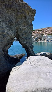
Milos or Melos is a volcanic Greek island in the Aegean Sea, just north of the Sea of Crete. Milos is the southwestern-most island in the Cyclades group.
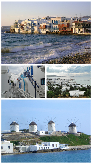
Mykonos is a Greek island, part of the Cyclades, lying between Tinos, Syros, Paros and Naxos. The island has an area of 85.5 square kilometres (33.0 sq mi) and rises to an elevation of 341 metres at its highest point. At the 2021 census, there were 10,704 inhabitants, most of whom lived in the largest town, Mykonos, which is on the west coast. The town is also known as Chora.

Antiparos (Greek: Αντίπαρος; Ancient Greek: Ὠλίαρος, romanized: Oliaros; Latin: Oliarus; is a small island in the southern Aegean, at the heart of the Cyclades, which is less than one nautical mile from Paros, the port to which it is connected with a local ferry. Saliagos island is the most ancient settlement in the Cyclades, and Despotiko, an uninhabited island in the southwest of Antiparos, is a place of great archaeological importance.
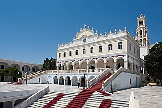
Tinos is a Greek island situated in the Aegean Sea. It is part of the Cyclades archipelago. The closest islands are Andros, Delos, and Mykonos. It has a land area of 194.464 square kilometres (75.083 sq mi) and a 2021 census population of 8,934 inhabitants.

Methana is a town and a former municipality on the Peloponnese peninsula, Greece. Since the 2011 local government reform it is part of the municipality Troizinia-Methana, of which it is a municipal unit. The municipal unit has an area of 50.161 km2.
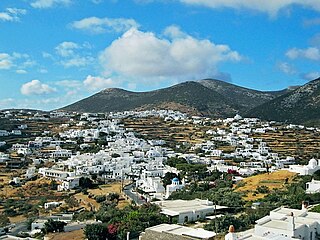
Sifnos is an island municipality in the Cyclades island group in Greece. The main town, near the center, known as Apollonia, is home of the island's folklore museum and library. The town's name is thought to come from an ancient temple of Apollo on the site of the church of Panayia Yeraniofora. The second-largest town is Artemonas, thought to be named after an ancient temple of Apollo's sister Artemis, located at the site of the church of Panayia Kokhi. The village of Kastro, was the capital of the island during ancient times until 1836. It is built on top of a high cliff on the island's east shore and today has extensive medieval remains and is the location of the island's archeological museum. The port settlement, on the west coast of the island is known as Kamares.

Serifos is a Greek island municipality in the Aegean Sea, located in the western Cyclades, south of Kythnos and northwest of Sifnos. It is part of the Milos regional unit. The area is 75.207 square kilometres (29.038 sq mi) and the population was 1,241 at the 2021 census. It is located about 170 kilometres ESE of the Athenian port of Piraeus.

Halki is a Greek island and municipality in the Dodecanese archipelago in the Aegean Sea, some 9 km (6 mi) west of Rhodes. It has an area of 28 km2 (11 sq mi). It is part of the Rhodes regional unit. It has a permanent population of 330, concentrated in the only village of Emporio. The 2021 census showed a population of 475 inhabitants. The community is divided in two parts, Chorio and Emporio.

Donousa, and sometimes spelled Donoussa, is an island and a former community in the Cyclades, Greece. Since the 2011 local government reform it is part of the municipality Naxos and Lesser Cyclades, of which it is a municipal unit. Donousa is the easternmost island of the Lesser Cyclades.

Kythnos, commonly called Thermia, is a Greek island and municipality in the Western Cyclades between Kea and Serifos. It is 56 nautical miles (104 km) from the Athenian harbor of Piraeus. The municipality Kythnos is 100.187 km2 (38.68 sq mi) in area and has a coastline of about 100 km (62 mi). Mount Kakovolo is island's highest peak (365m).

Ermoupoli, also known by the formal older name Ermoupolis or Hermoupolis, is a town and former municipality on the island of Syros, in the Cyclades, Greece. Since the 2011 local government reform, it is part of the municipality Syros-Ermoupoli, of which it is the seat and a municipal unit. It is also the capital of the South Aegean region. The municipal unit has an area of 11.181 km2.

Agathonísi is a small Greek island and municipality located at the northernmost point of the Dodecanese in Greece. It is surrounded by many smaller islands and is home to two villages, both inland; Megalo Chorio, and Mikro Chorio. Between them is the small settlement of Agios Georgios, which forms the island's only harbor and consists of a few hotels and restaurants. The island is also locally known as Gaidaro ("Donkey"), or by its ancient name Tragea.

Polýaigos is an uninhabited Greek island in the Cyclades near Milos and Kimolos. It is part of the community of Kimolos. Its name means "many goats", since it is inhabited only by goats. It was mentioned by several ancient geographers: Ptolemy, Pliny the Elder, and Pomponius Mela.

Irakleia or Heraklia is an island and a former community in the Cyclades, Greece. Since the 2011 local government reform it is part of the municipality Naxos and Lesser Cyclades, of which it is a municipal unit. Its population was officially 148 inhabitants at the 2021 census, and its land area 17.795 square kilometres (6.9 sq mi). It is a small island between the islands of Naxos and Ios. Close to Schoinoussa, Koufonisi, Donoussa, and Keros, together they form the Lesser Cyclades. The port is called Agios Georgios, while the "capital"/chora on the top of the island is called Panagia (Madonna). The biggest caves in the Cyclades are located on Irakleia. Irakleia can be reached by ferries from Athens, Naxos and Paros.

Koufonisia are a small island complex and a former community in the Cyclades, Greece. Since the 2011 local government reform it is part of the municipality Naxos and Lesser Cyclades, of which it is a municipal unit. The municipal unit has an area of 26.025 km2.

The HSC Super Runner Jet is a fast ferry owned and operated by Seajets. She was built in 1999 at Fincantieri, Riva Trigoso, Italy, for Sea Containers, but entered service only in 2000 for Sea Container's subsidiary Silja Line. In 2006 she was transferred to another Sea Containers subsidiary, SuperSeaCat. In 2009 she began service with Aegean Speed Lines between Piraeus, Serifos, Sifnos, Milos, Kimolos, Folegandros and Sikinos, as well as Paros and Naxos. In 2016, she was sold to Golden Star Ferries and renamed it Super Runner. In June 2021 Golden Star Ferries sold to Seajets her ships Superferry II, Superspeed, Supercat and Super Runner. Seajets renamed it Super Runner Jet.
Milos is one of the regional units of Greece. It is part of the region of South Aegean. The regional unit covers the islands of Kimolos, Milos, Serifos, Sifnos and several smaller islands in the Aegean Sea.
Zante Ferries, also known as ANMEZ in Greek, is a Greek ferry company operating from the Greek mainland to the West Cyclades, Samothrace and Lemnos from the ports of Piraeus and Alexandroupolis. The company was founded on 25 January 1991 and operates a fleet of conventional ferries.