
The German Bight is the southeastern bight of the North Sea bounded by the Netherlands and Germany to the south, and Denmark and Germany to the east. To the north and west it is limited by the Dogger Bank. The Bight contains the Frisian and Danish Islands. The Wadden Sea is approximately ten to twelve kilometres wide at the location of the German Bight. The Frisian islands and the nearby coastal areas are collectively known as Frisia. The southern portion of the bight is also known as the Heligoland Bight. Between 1949 and 1956 the BBC Sea Area Forecast used "Heligoland" as the designation for the area now referred to as German Bight.

Marmara Island is a Turkish island in the Sea of Marmara. With an area of 117.8 km2 (45.5 sq mi) it is the largest island in the Sea of Marmara and is the second largest island of Turkey after Gökçeada. It is the center of Marmara district in Balıkesir Province. Transportation is possible from Istanbul by ship and ferry, and by motorboat from Tekirdağ and Erdek. Marmara island is full of historical treasures which increase its attractiveness. The town of "Mermer Plaj" / Marble Beach takes its name from the marbles for which the town is famous and which give the island and the sea their name.

Sedef Island, is one of the nine islands consisting the Princes' Islands in the Sea of Marmara, near Istanbul, Turkey. Sedef Adası is officially a neighbourhood in the Adalar district of Istanbul.

Saros Bay or Gulf of Saros is an inlet of the northern Aegean Sea located north of the Gallipoli Peninsula in northwestern Turkey. The Archipelago of Saros is in the gulf. It consists the three small islands - The Big island, The Small island and The Little island.

Ongjin County is a county in Incheon Metropolitan City, South Korea. It consists of a group of islands in the Yellow Sea.
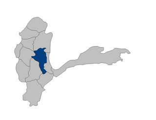
Baharak district is a district of Badakhshan Province, Afghanistan located about 30 km southeast of Fayzabad. The capital is the city of Baharak and the district is home to approximately 14,000 residents. The district is also called Baharistan.
The Rabbit Islands are a group of small uninhabited Turkish islands in the northern Aegean Sea. They are situated approximately four nautical miles off the mainland coast of the Turkish province of Çanakkale, 6 miles north of the island of Tenedos (Bozcaada), and 8 miles south-west of the entrance of the straights of the Dardanelles. The largest islet of the group, called Tavşan adası or Rabbit Island proper, is some 2 km (1 mi) long and 600 metres wide. To its south are three small rocky islets called Pırasa, Orak and Yılan.
Adır Island or Lim Island, is an island in Lake Van. During the Armenian genocide upwards of 12,000 Armenian women and children, crossed to the isle over a period of three days while a few dozen men covered their retreat from Hamidiye regiments. The Situation became soon critical because of a lack of food.,

Dana Island is a small Mediterranean island of Turkey.
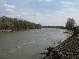
The Moldova–Romania border is the international border between Moldova and Romania, established after the dissolution of the Soviet Union. It is a fluvial boundary, following the course of the Prut and Danube. The boundary is 681.3 kilometres long, including 570 metres (1,870 ft) along the Danube.

Qum Island or Peschanniy, Azeri: Qum adası) is an island in the Bay of Baku, in the Caspian Sea.

Tavşan Adası or Neandros Adası is the smallest of the Princes' Islands in the Sea of Marmara, to the southeast of Istanbul, Turkey. It is under the administration of the Adalar district of Istanbul Province. The island has an area of 40 hectares.

Hoynat Islet is a Turkish islet in the Black Sea.

Yılan Island is a Mediterranean island in Turkey. It is administratively a part of Kaş ilçe (district) of Antalya Province at 36°12′53″N29°21′17″E.
Sıçan Island is a Mediterranean island in Turkey. It is administratively a part of Kaş ilçe (district) of Antalya Province at 36°13′18″N29°22′15″E.

Yassıca Island is an island in the Gulf of İzmir, Turkey. Sometimes the island is also called Alman Adası.
Koyun Island is a Turkish island in the Sea of Marmara. At 40°30′33″N27°34′40″E it is a part of Erdek ilçe (district) of Balıkesir Province. It is situated between the better known islands of Avşa Island and Paşalimanı Island.
Toprak Island is an Aegean island of Turkey. It is uninhabited. At 37°16′58″N27°21′59″E it is administratively a part of Milas ilçe (district) of Muğla Province. Its area is about 1 square kilometre (0.39 sq mi). Its distance from the mainland (Anatolia) is about 4.5 kilometres (2.8 mi).
Kalem Island is an Aegean island of Turkey. Administratively, the island is a part of Dikili ilçe (district) of İzmir Province at 9°0′12″N26°47′42″E. It is close to Bademli town and its distance to main land (Anatolia) is about 400 metres (1,300 ft). It is a narrow island where the maximum length in the north to south direction is about 1.5 kilometres (0.93 mi)
Panayır Island is an Aegean island of Turkey. It was once known as Ziraat Island. It is now also known as Altın Adası. The island is a part of Didim ilçe (district) of Aydın Province at 37°19′36″N27°19′50″E The area of the island is about 0.4 square kilometres (0.15 sq mi). Its distance to main land is 1.4 kilometres (0.87 mi).