Yassi Ada

Last updated
Turkey.Bodrum056.jpg
Reconstruction of 7th-century shipwreck at Yassi Ada, displayed at Bodrum Castle
History
Name7th-century wreck at Yassi Ada
OwnerByzantine Empire
In service625/626 AD or later
IdentificationByzantine
FateSunk
Notes
General characteristics
Depth106-129 feet (32-39 m)
Notes
  • Ship hull length: 21 m or 69 ft
  • Ship found by: Kanal Aras
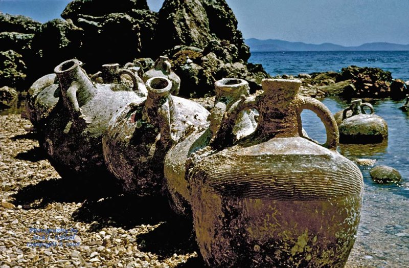
  • Number of amphora discovered:900
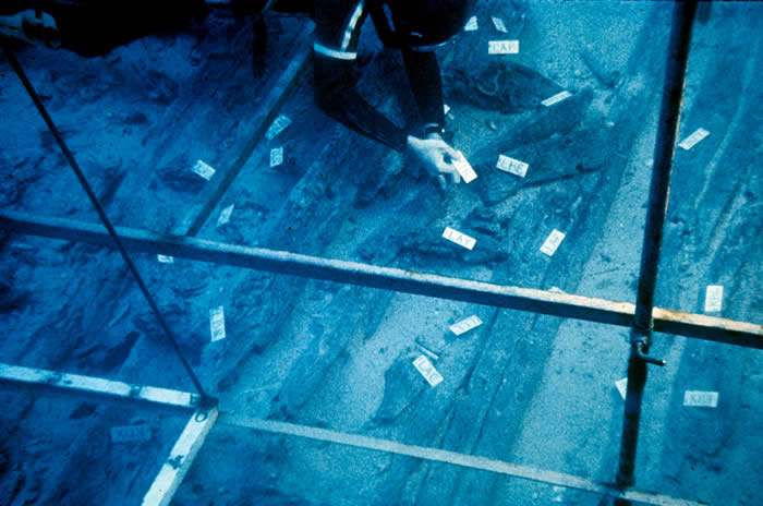
  • Number of dives during excavations:3,533
  • Cost of excavation expeditions:$95,000

Yassi Ada is an island off the coast of Bodrum, Turkey. [1] This area of the Mediterranean Sea is prone to strong winds, making a safe journey around the island difficult. The island could be called a ships' graveyard, on account of the number of wrecked ships off its southeastern tip. Three wreck sites have been excavated under the direction of George Bass of Texas A&M University. The first to be studied using archaeological techniques was a 4th-century Byzantine wreck, the second a 7th-century Byzantine wreck, and the third a 16th-century Ottoman wreck. Bass received funding for a summer excavation at the site from the University Museum of the University of Pennsylvania and the National Geographic Society.[ citation needed ]

Contents

Description

Yassi Ada is an island situated between Turgutreis and the Greek island of Pserimos. It measures 200 metres by 150 metres, with an elevation of 11 metres. [2] Approximately 200 metres southwest of the island is a dangerous reef that has caught many sailors unawares. The ruins of several vessels that crashed into the hidden reef can be found there, [3] representing a range of periods and styles. Ship material is sometimes visible on top of the reef, since it rises three metres above the surface of the water.

Fieldwork

The University Museum of the University of Pennsylvania under its director George Bass excavated a shipwreck site near Yassi Ada in 1967 and 1969. This expedition was funded by the Museum and the National Geographic Society. A few students from the university joined the team, along with an architect and a physician. The main site under excavation was a 4th-century vessel 19 metres in length, lying between 36 and 42 metres below the sea surface 100 metres south of Yassi Ada. Its hull was made of cypress, and the keel of white oak. There is also a 7th-century vessel near the reef, with one end resting over another wrecked vessel. Bass used the mini-sub Asherah to conduct some of the investigation of the site.

Dating method

Artifacts discovered at the main site included lamps, whose shapes were used to date the wreck. The vessel's mode of construction also helped to date the wreck site. The vessel was determined to be from the 4th century.

Archaeological Finds

Finds from the site include 1,100 amphorae in three different styles. The first style has a well-fired texture, is reddish-brown in color, and is estimated to hold 37–40 litres. The second is similar in pattern and design to the first, but its body is more cylindrical. The third style, the smallest, is estimated to hold 13.7–14.4 litres. Its base is round, with a button in the centre. The color is orange-brown.

Byzantine trade history

Trade with the East became important to acquire materials that were seen as necessities in the Byzantine Empire. This Empire had three main trade routes, ranging from the quickest to the safest. The quickest route took sailors through Sogdiana to Persia and thence to the Empire. The second quickest route went from the Indian Ocean to the Red Sea. The third route was the longest and safest. The Byzantine Empire often had conflicts with Persia, so this route bypassed Persian land to prevent Byzantine ships from being sunk or attacked. It went from Central Asia through the Caspian Sea to the Black Sea, avoiding all contact with Persia. Some caravans loaded with silk did, however, pass through Persia to reach the Empire. Trade with Persians was risky because of the "frequent wars between Byzantine and Persia  ... Roman commerce suffered heavily both through the interpretation of communication and through the raising of the price of raw material". [4] In towns at war with Persia, the price for raw materials was high, and the finished product cost more than in other cities. In the 6th century, the Empire obtained sandalwood, aloes, and silk from Ceylon, as trade with India and Ethiopia was the main business in this part of the world. During this time, the Empire also traded for copper in Kalliana; raw material and labor came from the north.

Though the Empire saw difficult times in the 7th century, trade continued. Food, commodities, and other items were sold at a fixed price to prevent rivals to the ruler and government, as specified in the first part of the constitution, which also allowed citizens to purchase basic necessities at a reasonable and affordable price. Another part sought to protect producers by eliminating a vertical[ clarification needed ] monopoly. [5] Work was divided equally amongst all members,[ clarification needed (of what?)] providing for a low competition rate. The third part of the constitution claims that private producers receive aid only from family members, although some might also have slaves to help in the business. Such businesses sold directly to customers, and they had fewer customers than other markets. The private producer produced items for himself and his family.

During this time, Constantinople especially continued trade with Africa, while other Alexandrian ships began to reach places as far west as Britain. The Empire had laws on trade and sailing. One of them. which grew out of the custom of marine regulation, [6] restricted ships to sailing in the winter months. Sailing was later suspended for four months between November and March because of dangers such as pirates, land-based robbers, and ships being set on fire. Byzantine ships would sail together to give aid to each other, and they began to carry armed men for further protection. Another law declares that money lent for a vessel does not have to be returned if that vessel is lost or destroyed. [7] The Byzantine Empire had a vast network of trade routes, and the government issued laws to protect merchants and businesses by providing route options for safety and protection.

Related Research Articles

<span class="mw-page-title-main">History of the Mediterranean region</span> Historical development of the Mediterranean

The history of the Mediterranean region and of the cultures and people of the Mediterranean Basin is important for understanding the origin and development of the Mesopotamian, Egyptian, Canaanite, Phoenician, Hebrew, Carthaginian, Minoan, Greek, Persian, Illyrian, Thracian, Etruscan, Iberian, Roman, Byzantine, Bulgarian, Arab, Berber, Ottoman, Christian and Islamic cultures. The Mediterranean Sea was the central superhighway of transport, trade and cultural exchange between diverse peoples encompassing three continents: Western Asia, North Africa, and Southern Europe.

<span class="mw-page-title-main">Maritime archaeology</span> Archaeological study of human interaction with the sea

Maritime archaeology is a discipline within archaeology as a whole that specifically studies human interaction with the sea, lakes and rivers through the study of associated physical remains, be they vessels, shore-side facilities, port-related structures, cargoes, human remains and submerged landscapes. A specialty within maritime archaeology is nautical archaeology, which studies ship construction and use.

<span class="mw-page-title-main">Robert Ballard</span> Retired US Navy officer and professor of oceanography

Robert Duane Ballard is an American retired Navy officer and a professor of oceanography at the University of Rhode Island who is noted for his work in underwater archaeology and marine geology. He is best known by the general public for the discoveries of the wrecks of the RMS Titanic in 1985, the battleship Bismarck in 1989, and the aircraft carrier USS Yorktown in 1998. He discovered the wreck of John F. Kennedy's PT-109 in 2002 and visited Biuku Gasa and Eroni Kumana, who saved its crew.

<span class="mw-page-title-main">Wreck diving</span> Recreational diving on wrecks

Wreck diving is recreational diving where the wreckage of ships, aircraft and other artificial structures are explored. The term is used mainly by recreational and technical divers. Professional divers, when diving on a shipwreck, generally refer to the specific task, such as salvage work, accident investigation or archaeological survey. Although most wreck dive sites are at shipwrecks, there is an increasing trend to scuttle retired ships to create artificial reef sites. Diving to crashed aircraft can also be considered wreck diving. The recreation of wreck diving makes no distinction as to how the vessel ended up on the bottom.

The Institute of Nautical Archaeology (INA) is an organization devoted to the study of humanity's interaction with the sea through the practice of archaeology.

<span class="mw-page-title-main">Bodrum Castle</span> Castle in Bodrum, Turkey

Bodrum Castle is a historical fortification located in southwest Turkey in the port city of Bodrum, built from 1402 onwards, by the Knights of St John as the Castle of St. Peter or Petronium. A transnational effort, it has four towers known as the English, French, German, and Italian towers, bearing the names of the nations responsible for their construction. The chapel was built around 1407 and the first walls completed in 1437. The castle started reconstruction in the late 14th century, only to be taken over by the Islamic Ottoman Empire in 1523. The chapel was converted to a mosque, and a minaret was added. The castle remained under the empire for almost 400 years. After remaining empty following World War I, in the early 1960s, the castle became the home for the Bodrum Museum of Underwater Archaeology. In 2016 it was inscribed in the UNESCO Tentative list of World Heritage Sites in Turkey.

<span class="mw-page-title-main">Dromon</span> Type of warship of the Byzantine navy

A dromon was a type of galley and the most important warship of the Byzantine navy from the 5th to 12th centuries AD, when they were succeeded by Italian-style galleys. It was developed from the ancient liburnian, which was the mainstay of the Roman navy during the Empire.

<span class="mw-page-title-main">Yassıada</span> An island in Turkey

Yassıada, officially renamed Democracy and Freedom Island in 2013, is one of the Princes' Islands in the Sea of Marmara, to the southeast of Istanbul. In Byzantine times, it was known as Plati. It should not be confused with Yassi Ada, a different island in the Aegean Sea.

<span class="mw-page-title-main">Berezan Island</span> Island in Mykolaiv Raion, Mykolaiv Oblast, Ukraine

Berezan is an island in the Black Sea at the entrance of the Dnieper-Bug Estuary, Mykolaiv Raion, Mykolaiv Oblast, Ukraine. Located 8 kilometers from the city of Ochakiv and 4 kilometers from the resort village of Rybakivka. It is often being confused with the artificial island of Pervomaisky that is located within Dnieper-Bug Estuary. The Berezan island measures approximately 900 metres in length by 320 metres in width, the height of the northern part is 3-6 metres, the southern part is 21 metres. It is separated from the mainland by about a mile and a half of shallow water. Berezan is an integral part of the historical and archaeological reserve of the National Academy of Sciences of Ukraine "Olvia". The island is uninhabited. In the summer, archaeological expeditions of the IA NASU and the State Hermitage Museum work here. The archaeological site is regularly destroyed as a result of unauthorized excavations.

<span class="mw-page-title-main">Maritime history of Florida</span> History of waters in and adjacent to Florida

The maritime history of Florida describes significant past events relating to the U.S. state of Florida in areas concerning shipping, shipwrecks, and military installations and lighthouses constructed to protect or aid navigation and development of the Florida peninsula.

Edgerton Alvord Throckmorton, known as Peter Throckmorton, was an American photojournalist and a pioneer underwater archaeologist.

<span class="mw-page-title-main">Black Assarca shipwreck</span> Shipwreck

The Black Assarca shipwreck was first discovered by tourists in 1995, at Black Assarca Island, Eritrea. The wreck was surveyed in 1995 and partially excavated in 1997 by the Institute of Nautical Archaeology, under the auspices of the Ministry of Marine Resources of Eritrea.

Ancient boat building methods can be categorized as one of hide, log, sewn, lashed-plank, clinker, shell-first, and frame-first. While the frame-first technique dominates the modern ship construction industry, the ancients relied primarily on the other techniques to build their watercraft. In many cases, these techniques were very labor-intensive and/or inefficient in their use of raw materials. Regardless of differences in ship construction techniques, the vessels of the ancient world, particularly those that plied the waters of the Mediterranean Sea and the islands of Southeast Asia were seaworthy craft, capable of allowing people to engage in large-scale maritime trade.

<span class="mw-page-title-main">Phoenicians and wine</span> Relationship between Phoenician culture and wine

The culture of the ancient Phoenicians was one of the first to have had a significant effect on the history of wine. Phoenicia was a civilization centered in current day Lebanon. Between 1550 BC and 300 BC, the Phoenicians developed a maritime trading culture that expanded their influence from the Levant to North Africa, the Greek Isles, Sicily, and the Iberian Peninsula. Through contact and trade, they spread not only their alphabet but also their knowledge of viticulture and winemaking, including the propagation of several ancestral varieties of the Vitis vinifera species of wine grapes.

Ancient Black Sea shipwrecks found in the Black Sea date to Antiquity. In 1976, Willard Bascom suggested that the deep, anoxic waters of the Black Sea might have preserved ships from antiquity because typical wood-devouring organisms could not survive there. At a depth of 150m, the Black Sea contains insufficient oxygen to support most familiar biological life forms.

The Molasses Reef Shipwreck is the site of a ship which wrecked in the Turks and Caicos Islands early in the 16th century. It is the oldest wreck of a European ship in the Americas to have been scientifically excavated.

<span class="mw-page-title-main">Turks and Caicos National Museum</span>

The Turks and Caicos National Museum is the national museum of the Turks and Caicos Islands. It is located in Guinep House on Front Street to the north of Cockburn Town on Grand Turk Island, which is also the capital of the archipelago. Established in the 1980s and opened in 1991, the museum is publicly funded as a nonprofit trust. It exhibits pre-historic Lucayan culture and records the history of the islands of the colonial era and the slave trade, all related to the sea. An arboretum is adjacent to the museum.

<i>San Esteban</i> (1554 shipwreck) Spanish cargo ship shipwrecked in 1554

San Esteban was a Spanish cargo ship that was wrecked in a storm in the Gulf of Mexico on what is now the Padre Island National Seashore in southern Texas on 29 April 1554.

<span class="mw-page-title-main">Maritime archaeology of East Africa</span>

Maritime archaeology in East Africa spans the range from the horn of Somalia south to Mozambique, and includes the various islands and island chains dotting the map off the coast of Somalia, Mozambique, Tanzania and Kenya. Primary areas along this coast include the Zanzibar, Lamu, and Kilwa Archipelagos. Although East African societies developed nautical capabilities for themselves, most of the maritime artifacts point to external merchants from Mediterranean cultures like Egypt and Greece, Indian and Chinese from South and East Asia in the early stages, to the great European powers during the Ages of Colonization and Imperialism.

<span class="mw-page-title-main">Maritime Silk Road</span> Ancient and medieval maritime trade route

The Maritime Silk Road or Maritime Silk Route is the maritime section of the historic Silk Road that connected Southeast Asia, East Asia, the Indian subcontinent, the Arabian Peninsula, eastern Africa, and Europe. It began by the 2nd century BCE and flourished until the 15th century CE. The Maritime Silk Road was primarily established and operated by Austronesian sailors in Southeast Asia who sailed large long-distance ocean-going lashed‑lug trade ships. The route was also utilized by the dhows of the Tamil merchants in South Asia, and the Persian and Arab traders in the Arabian Sea and beyond. China also started building their own trade ships (chuán) and followed the routes in the later period, from the 10th to the 15th centuries CE.

References

  1. "Yassi Ada". GeoNames . Retrieved November 22, 2021.
  2. Bass 1982, p. 3
  3. Bass 1982, p. 4
  4. Baynes p 209
  5. Browning p 107
  6. Baynes 218
  7. Byanes p 219

Bibliography

36°45′11″N27°45′49″E / 36.75306°N 27.76367°E / 36.75306; 27.76367 (Yassi Ada)