Maritime history dates back thousands of years. The first prehistoric boats are presumed to have been dugout canoes which were developed independently by various Stone Age populations around 10,000 years ago, with the oldest surviving boat being the Pesse canoe. In ancient history, various vessels were used for coastal fishing and travel.[1][obsoletesource] Some evidence suggests that humans may have crossed the sea as early as 700,000 years ago.
In ancient maritime history,[2] evidence of maritime trade between civilizations dates back at least five millennia. Egyptians had trade routes through the Red Sea, importing spices from the "Land of Punt" and from Arabia,[3][4] and the Sumerians traded with the Indus Valley civilization around the same time. By the time of Julius Caesar of the Roman Empire, several well-established combined land-sea trade routes depended upon water transport through the sea around the rough inland terrain features to its north. The search for the source of spices in these maritime trade routes later led to the Age of Discovery.
Maritime prehistory
General principles
The earliest seafaring is presumed to have developed in the "nursery" areas of Island Southeast Asia (ISEA) and the Mediterranean. Both ISEA and the Mediterranean had a warm climate and, particularly in the former, large numbers of intervisible islands; both assisted early seafarers.[5][6] Water transport also developed on major rivers, such as the Nile.
The first watercraft are likely to have been rafts, as these make less demands on the woodworking skills of pre-neolithic builders. Rafts or hide-covered boats (e.g. coracle) have a low probability of surviving in an archaeological site; there are historical instances of rafts being dismantled after use and the components being used for other purposes, further reducing the chances of archaeological survival. Therefore, maritime transport has to be inferred from evidence such as human migration which cannot have been carried out by land, even in cases of lowered sea levels due to extensive glaciation. Other presumed evidence of water transport has proved problematical. Excavated bones of pelagic fish species (such as tuna) have been erroneously interpreted as demonstrating deep-sea fishing. Prior to fish stocks being reduced by commercial fishing, these species have been readily caught where deep water exists close to the shoreline.[6]
The invention (or adoption) of the sail is believed to have happened quite late in the prehistory of maritime transport, coinciding with other changes in the process of neolithicisation. Iconographic evidence of sail in Egypt dates to the late fourth millennium BC, and there is suggestive evidence in the eastern Mediterranean and the Persian Gulf in the late third millennium BC. These advances in water transport are broadly contemporaneous with wheeled transport pulled by draught animals (examples c.3000-2000 BC). The invention of new forms of transport technology, both at sea and on land, have posed questions about relationships between the processes that have come into play with each development.[7]
Whilst the invention of the sail may appear obvious to a modern seafarer, its introduction and then spread into other regions (or the independent invention in those regions) happened slowly. From the eastern Mediterranean and Red Sea/Persian Gulf c.2500 BC, expansion into the central Mediterranean and the west coast of India happened c.2000 BC. Eastward spread into the Bay of Bengal and Island Southeast Asia has been dated to c.1000 BC, with spread into the western Mediterranean at about the same time. Northern Europe, excluding Nordic countries, has evidence of sail use from the early years AD, whilst Scandinavia appears not to have used sails until late in the first millennium AD. Sailing was not used in the Caribbean until the arrival of Columbus' ships in 1492.[8]
Whether the sail was invented on different occasions in different places is difficult to assess, with diffusionist theories falling in and out of fashion. One instance of independent invention may be in the region of the Guayaquil river in modern Ecuador.[9] Sails of a relatively unique design were being used when Europeans first arrived in the area in the 16th century. The geography of the Guayaquil river is reminiscent of that of the Nile, with the prevailing wind going in the opposite direction to the flow of the river. This allows drifting downstream and sailing upstream: a suitable situation to encourage invention of sailing.[10]
Island Southeast Asia into greater Australia
The lowered sea levels of the Pleistocene made some of the modern-day islands of Sundaland accessible via land bridges. However, the spread of anatomically modern humans across the Wallace line and into Sahul necessitated crossing bodies of water. Remains of stone tools and marine shells in Liang Sarru, Salibabu Island, North Sulawesi, dated to 32,000–35,000 years ago, is possible evidence for the longest sea voyage by Paleolithic humans ever recorded. The island was previously uninhabited by humans or hominins and can only be reached from either Mindanao or the Sangihe Islands by crossing an expanse of water at least 100km (62mi) wide, even during the low sea levels of the Pleistocene. Other evidence of early maritime transport are the appearance of obsidian tools with the same source on neighboring islands. These include the Philippine obsidian network (Mindoro and Palawan, c.33,000-28,000 BP), and the Wallacea obsidian network (Timor, Atauro, Kisar, Alor, c.22,000 BP). However, the method of crossing remains unknown and could have ranged from simple rafts to dugout canoes by the terminal Pleistocene.[11][12][13]
The sea crossing by humans to the Sahul landmass (modern Australia and New Guinea) from the Sundaland peninsula occurred around 53,000 to 65,000 years ago. Even with the lower sea level of that time, this crossing would have involved travelling out of sight of land–the overall distances involved at the possible crossing points are all over 55 miles. It is likely that large bamboo rafts were used, possibly with a sail of some sort. Up until 58,000 BP, the winds during the Northern Australian wet season were particularly favourable for making this crossing (relevant even without sails). The reduction in favourable winds after that date fits well with the single colonisation phase of Australia during prehistory.[14]:26–29[15][16]
In the history of whaling, humans are believed to have begun whaling in Korea at least 6000 BC.[17] The oldest known method of catching whales is to simply drive them ashore by placing a number of small boats between the whale and the open sea and attempting to frighten them with noise, activity, and perhaps small, non-lethal weapons such as arrows.[18]
The acquisition of the catamaran and outrigger boat technology by the non-Austronesian peoples in Sri Lanka and southern India is the result of Austronesian contact with the region, including the Maldives and Laccadive Islands. This is estimated to have occurred around 1000 to 600 BC and onwards, and led to the development of India and Sri Lanka's own maritime trade networks. This may have possibly included limited colonization that have since been assimilated. This is still evident in Sri Lankan and South Indian languages. For example, Tamilpaṭavu, Telugupaḍava, and Kannadapaḍahu, all meaning "ship", are all derived from Proto-Hesperonesian*padaw, "sailboat", with Austronesian cognates like Javaneseperahu, Kadazanpadau, Maranaopadaw, Cebuanoparáw, Samoanfolau, Hawaiianhalau, and Māoriwharau.[20]
Similarly the first encounter with large sea-going ships by the Chinese is through trade with Southeast Asian Austronesian ships (likely Javanese or Sumatran) during the Han dynasty (220 BC–200 AD) as recorded by the Chinese historian Wan Chen (萬震) in his 3rd century AD book "Strange Things of the South" (Nánzhōu Yìwùzhì – 南州異物志). This led to the development of China's own maritime technologies later on, during the Song dynasty in the 10th to 13th century AD.[24][25]:38–42
Austronesian seafarers used environmental navigation systems: orientation at sea is carried out using a variety of different natural signs, and by using an astronomy technique called "star path navigation". Basically, the navigators determined the course of the ship to the destination by recognising the rising and setting positions of certain stars on the horizon.[30]:10[31]
Māori people of New Zealand are said to have Navigated following the zodiacal constellation of Scorpio, between Libra and Sagittarius in the southern sky positioned at about 16 hours 30 minutes right ascension and 30° south declination to find, Aotearoa, "The Land of the Long, White, Cloud".
Ancient maritime routes usually began in the Far East or down river from Madhya Pradesh with transshipment via historic Bharuch (Bharakuccha), traversed past the inhospitable coast of today's Iran then split around Hadhramaut into two streams north into the Gulf of Aden and thence into the Levant, or south into Alexandria via Red Sea ports such as Axum. Each major route involved transhipping to pack animal caravan, travel through desert country and risk of bandits and extortionate tolls by local potentiates.[32][bettersourceneeded]
Maritime trade began with safer coastal trade and evolved with the utilization of the monsoon winds, soon resulting in trade crossing boundaries such as the Arabian Sea and the Bay of Bengal.[33][failed verification]South Asia had multiple maritime trade routes which connected it to Southeast Asia, thereby making the control of one route resulting in maritime monopoly difficult.[33][failed verification] Indian traders had a choice of routes to Southeast Asian states, so protecting them from one power controlling trade that went through their territory.[33] By making use of the maritime trade routes, bulk commodity trade became possible for the Romans in the 2nd century BC.[34] A Roman trading vessel could span the Mediterranean in a month at one-sixtieth the cost of over-land routes.[35]
The first warships of Ancient Egypt were constructed during the early Middle Kingdom, and perhaps – at the end of the Old Kingdom, but the first mention and a detailed description of a large enough and heavily armed ship dates from 16th century BC. "And I ordered to build twelve warships with rams, dedicated to Amun or Sobek, or Maat and Sekhmet, whose image was crowned best bronze noses. Carport and equipped outside rook over the waters, for many paddlers, having covered rowers deck not only from the side, but and top. and they were on board eighteen oars in two rows on the top and sat on two rowers, and the lower – one, a hundred and eight rowers were. And twelve rowers aft worked on three steering oars. And blocked Our Majesty ship inside three partitions (bulkheads) so as not to drown it by ramming the wicked, and the sailors had time to repair the hole. And Our Majesty arranged four towers for archers – two behind, and two on the nose and one above the other small – on the mast with narrow loopholes. they are covered with bronze in the fifth finger (3.2mm), as well as a canopy roof and its rowers. and they have (carried) on the nose three assault heavy crossbow arrows so they lit resin or oil with a salt of Seth (probably nitrate) tore a special blend and punched (?) lead ball with a lot of holes (?), and one of the same at the stern. and long ship seventy five cubits (41m), and the breadth sixteen, and in battle can go three-quarters of iteru per hour (about 6.5 knots)..." The text of the tomb of Amenhotep I (KV39). When Thutmose III achieved warships displacement up to 360 tons and carried up to ten new heavy and light to seventeen catapults based bronze springs, called "siege crossbow" – more precisely, siege bows. Still appeared giant catamarans that are heavy warships and times of Ramesses III used even when the Ptolemaic dynasty.[37]
According to the Greek historian Herodotus, Necho II sent out an expedition of Phoenicians, which reputedly, at some point between 610 and before 594 BC, sailed in three years from the Red Sea around Africa to the mouth of the Nile. Some Egyptologists dispute that an Egyptian Pharaoh would authorize such an expedition,[38] except for the reason of trade in the ancient maritime routes.
The belief in Herodotus' account, handed down to him by oral tradition,[39] is primarily because he stated with disbelief that the Phoenicians "as they sailed on a westerly course round the southern end of Libya (Africa), they had the sun on their right – to northward of them" (The Histories 4.42) – in Herodotus' time it was not generally known that Africa was surrounded by an ocean (with the southern part of Africa being thought connected to Asia[40]). So fantastic an assertion is this of a typical example of some seafarers' story and Herodotus therefore may never have mentioned it, at all, had it not been based on facts and made with the according insistence.[41]
This early description of Necho's expedition as a whole is contentious, though; it is recommended that one keep an open mind on the subject;[42] but Strabo, Polybius, and Ptolemy doubted the description. Egyptologist A. B. Lloyd suggests that the Greeks at this time understood that anyone going south far enough and then turning west would have the Sun on their right but found it unbelievable that Africa reached so far south. He suggests that "It is extremely unlikely that an Egyptian king would, or could, have acted as Necho is depicted as doing" and that the story might have been triggered by the failure of Sataspes' attempt to circumnavigate Africa under Xerxes the Great.[43] Regardless, it was believed by Herodotus and Pliny.[44]
In ancient times the Kingdom of Punt, which is believed by several Egyptologists to have been situated in the area of modern-day Somalia, had a steady trade link with the Ancient Egyptians and exported the precious natural resources such as myrrh, frankincense and gum. This trade network continued all the way into the classical era. The city states of Mossylon, Opone, Malao, Mundus and Tabae in Somalia engaged in a lucrative trade network connecting Somali merchants with Phoenicia, Ptolemic Egypt, Greece, Parthian Persia, Saba, Nabataea and the Roman Empire. Somali sailors used the ancient Somali maritime vessel known as the beden to transport their cargo.
The Mediterranean
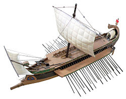
Minoan traders from Crete were active in the eastern Mediterranean by the 2nd millenniumBC. The Phoenicians were an ancient civilization centered in the north of ancient Canaan, with its heartland along the coast of modern-day Lebanon, Western Syria and northern Israel. Phoenician civilization was an enterprising maritime trading culture that spread across the Mediterranean during the first millenniumBC, between the period of 1200 BC to 900BC. The recent discovery of three shipwrecks off the coast of Israel provides new insights into the history of maritime trade during the Iron Age.[50] Though ancient boundaries of such city-centered cultures fluctuated, the city of Tyre seems to have been the southernmost. Sarepta between Sidon and Tyre, is the most thoroughly excavated city of the Phoenician homeland. The Phoenicians often traded by means of a galley, a man-powered sailing vessel. They were the first civilization to create the bireme. There is still debate on the subject of whether the Canaanites and Phoenicians were different peoples or not.
The Mediterranean was the source of the vessel, galley, developed before 1000BC, and development of nautical technology supported the expansion of Mediterranean culture. The Greektrireme was the most common ship of the ancient Mediterranean world, employing the propulsion power of oarsmen. Mediterranean peoples developed lighthouse technology and built large fire-based lighthouses, most notably the Lighthouse of Alexandria, built in the 3rd centuryBC (between 285 and 247BC) on the island of Pharos in Alexandria, Egypt.
Many in ancient western societies, such as Ancient Greece, were in awe of the seas and deified them, believing that man no longer belonged to himself when once he embarked on a sea voyage. They believed that he was liable to be sacrificed at any time to the anger of the great Sea God. Before the Greeks, the Carians were an early Mediterranean seagoing people that travelled far. Early writers do not give a good idea about the progress of navigation nor that of the man's seamanship. One of the early stories of seafaring was that of Odysseus.
In Greek mythology, the Argonauts were a band of heroes who, in the years before the Trojan War, accompanied Jason to Colchis in his quest to find the Golden Fleece. Their name comes from their ship, the Argo which in turn was named after its builder Argus. Thus, "Argonauts" literally means "Argo sailors". The voyage of the Greek navigator Pytheas of Massalia is an example of a very early voyage. A competent astronomer and geographer, Pytheas ventured from Greece to Western Europe and the British Isles.[51]
The periplus, literally "a sailing-around', in the ancient navigation of Phoenicians, Greeks, and Romans was a manuscript document that listed in order the ports and coastal landmarks, with approximate distances between, that the captain of a vessel could expect to find along a shore. Several examples of periploi have survived.
The earliest seagoing culture in the Mediterranean is associated with Cardium pottery. Their earliest impressed ware sites, dating to 6400–6200 BC, are in Epirus and Corfu. Settlements then appear in Albania and Dalmatia on the eastern Adriatic coast dating to between 6100 and 5900 BC.[53] The earliest date in Italy comes from Coppa Nevigata on the Adriatic coast of southern Italy, perhaps as early as 6000 cal B.C. Also during Su Carroppu culture in Sardinia, already in its early stages (low strata into Su Coloru cave, c.6000 BC) early examples of cardium pottery appear.[54] Northward and westward all secure radiocarbon dates are identical to those for Iberia c.5500 cal BC, which indicates a rapid spread of cardium and related cultures: 2,000km from the gulf of Genoa to the estuary of the Mondego in probably no more than 100–200 years. This suggests a seafaring expansion by planting colonies along the coast.[55]
In Ionia (the modern Aegean coast of Turkey) the Greek cities, which included great centres such as Miletus and Halicarnassus, were unable to maintain their independence and came under the rule of the Persian Empire in the mid-6th centuryBC. In 499 BC the Greeks rose in the Ionian Revolt, and Athens and some other Greek cities went to their aid. In 490 BC, the Persian Great King, DariusI, having suppressed the Ionian cities, sent a fleet to punish the Greeks. The Persians landed in Attica, but were defeated at the Battle of Marathon by a Greek army led by the Athenian general Miltiades. The burial mound of the Athenian dead can still be seen at Marathon. Ten years later Darius' successor, XerxesI, sent a much more powerful force by land. After being delayed by the Spartan King Leonidas I at Thermopylae, Xerxes advanced into Attica, where he captured and burned Athens. But the Athenians had evacuated the city by sea, and under Themistocles they defeated the Persian fleet at the Battle of Salamis. Ayear later, the Greeks, under the Spartan Pausanias, defeated the Persian army at Plataea. The Athenian fleet then turned to chasing the Persians out of the Aegean Sea, and in 478BC they captured Byzantium. In the course of doing so Athens enrolled all the island states and some mainland allies into an alliance, called the Delian League because its treasury was kept on the sacred island of Delos. The Spartans, although they had taken part in the war, withdrew into isolation after it, allowing Athens to establish unchallenged naval and commercial power.
The Punic Wars were a series of three wars fought between Rome and Carthage. The main cause of the Punic Wars was the clash of interests between the existing Carthaginian Empire and the expanding Roman sphere of influence. The Romans were initially interested in expansion via Sicily, part of which lay under Carthaginian control. At the start of the first Punic War, Carthage was the dominant power of the Mediterranean, with an extensive maritime empire, while Rome was the rapidly ascending power in Italy. By the end of the third war, after the deaths of many hundreds of thousands of soldiers from both sides, Rome had conquered Carthage's empire and razed the city, becoming in the process the most powerful state of the Western Mediterranean. With the end of the Macedonian wars – which ran concurrently with the Punic Wars – and the defeat of the Seleucid EmperorAntiochus III the Great in the Roman-Syrian War (Treaty of Apamea, 188BC) in the eastern sea, Rome emerged as the dominant Mediterranean power and the most powerful city in the classical world. This was a turning point that meant that the civilization of the ancient Mediterranean would pass to the modern world via Europe instead of Africa.
Pre-Roman Britain
Ancient British canoe
The Coracle, a small single-passenger-sized float, has been used in Britain since before the first Roman invasion as noted by the invaders. Coracles are round or oval in shape, made of a wooden frame with a hide stretched over it then tarred to provide waterproofing. Being so light, an operator can carry the light craft over the shoulder. They are capable of operating in mere inches of water due to the keel-less hull. The early people of Wales used these boats for fishing and light travel and updated models are still in use to this day on the rivers of Scotland and Wales.
Early Britons also used the dugout canoe. Examples of these canoes have been found buried in marshes and mud banks of rivers at lengths of upward eight feet.[56]
In 1992 a notable archaeological find, named the "Dover Bronze Age Boat", was unearthed from beneath what is modern day Dover, England. The Bronze Age boat which is about 9.5 meters long × 2.3 meters wide is believed to have been a seagoing vessel. Carbon dating reveals that the craft dating from approximately 1600BC might be the oldest known sea-going boat. The hull was of half oak logs and side panels also of oak were stitched on with yew lashings. Both the straight-grained oak and yew bindings are now extinct as a shipbuilding method in England. A reconstruction in 1996 proved that a crew between four and sixteen paddlers could have easily propelled the boat during Force4 winds upwards of four knots but with a maximum of 5 knots (9km/h). The boat could have easily carried a significant amount of cargo and with a strong crew may have been able to traverse near thirty nautical miles in a day.[57]
Northern Europe
The Norsemen, or 'people from the North', were people from southern and central Scandinavia which established states and settlements Northern Europe from the late 8th century to the 11th century. Vikings has been a common term for Norsemen in the early medieval period, especially in connection with raids and monastic plundering made by Norsemen in Great Britain and Ireland.
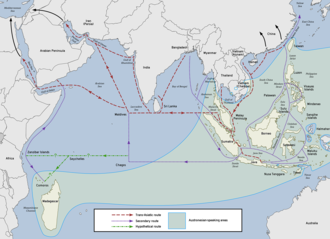
Austronesians in Maritime Southeast Asia developed very early maritime trade networks in the Neolithic. The first of which is the Maritime Jade Road. It lasted for around 3,000 years, from 2000 BCE to 1000 CE. It was initially established by the indigenous peoples of Taiwan and the Philippines. Raw jade was sourced from deposits in Taiwan and worked into ornaments in the Philippines (the most notable and most numerous of which are double-headed pendants known as lingling-o). This network later included parts of Vietnam, Malaysia, Indonesia, Thailand, and other areas in Southeast Asia where these jade ornaments, along with other trade goods, were exchanged (also known as the Sa Huynh-Kalanay Interaction Sphere).[59][60][61][62] The wide distribution throughout Island Southeast Asia of the ceremonial bronze drums (c.600 BCE to 400 CE) sourced from the Dong Son culture of northern Vietnam is also evidence of the antiquity and density of this prehistoric Southeast Asian maritime network.[63]
By around the 2nd century BCE, the prehistoric Austronesian jade and spice trade networks in Southeast Asia fully connected with the maritime trade routes of South Asia, the Middle East, eastern Africa, and the Mediterranean, becoming what is now known as the Maritime Silk Road. Prior to the 10th century, the eastern part of the route was primarily used by Southeast Asian Austronesian traders using distinctive sewn-plank and lashed-lug ships, although Persian and Tamil traders also sailed the western parts of the routes.[63][72] It allowed the exchange of goods from East and Southeast Asia on one end, all the way to Europe and eastern Africa on the other.[73][72]
Han and Tang dynasty Chinese records also indicate that the early Chinese Buddhist pilgrims to South Asia booked passage with the Austronesian ships (which they called the k'un-lun po) that traded in the Chinese port city of Guangzhou. Books written by Chinese monks like Wan Chen and Hui-Lin contain detailed accounts of the large trading vessels from Southeast Asia dating back to at least the 3rd century CE.[80][81]:347[82]:262
Srivijaya, a Hindu-Buddhist Austronesian polity founded at Palembang in 682 CE, rose to dominate the trade in the region around the straits of Malacca and Sunda and the South China Sea emporium by controlling the trade in luxury aromatics and Buddhist artifacts from West Asia to a thriving Tang market.[63]:12 It emerged through the conquest and subjugation of neighboring thalassocracies. These included Melayu, Kedah, Tarumanagara, and Mataram, among others. These polities controlled the sea lanes in Southeast Asia and exploited the spice trade of the Spice Islands, as well as maritime trade-routes between India and China.[83]
These maritime routes persisted (with increasing participation of other maritime cultures) into the medieval era, before declining and being replaced with European trade routes during the colonial era in the 15th century.[63][87][88]
In the Indian maritime history, the world's first tidal dock was built in phase II of Lothal[89][90] during the Harappan civilisation near the present day Mangrol harbour on the Gujarat coast. Other ports were probably at Balakot and Dwarka. However, it is probable that many small-scale ports, and not massive ports, were used for the Harappan maritime trade.[91] Ships from the harbour at these ancient port cities established trade with Mesopotamia,[92] where the Indus Valley may have been known as Meluhha.
Japan had a navy by at least the 6th century, with their invasions and involvement in political alliances during the Three Kingdoms of Korea. A joint alliance between the Korean Silla Kingdom and the Chinese Tang dynasty (618–907 AD) heavily defeated the Japanese and their Korean allies of Baekje in the Battle of Baekgang on August 27 to August 28 of the year 663 AD. This decisive victory expelled the Japanese force from Korea and allowed the Tang and Silla to conquer Goguryeo.
Ancient Rome had a variety of ships that played crucial roles in its military, trade, and transportation activities.[94] Rome was preceded in the use of the sea by other ancient, seafaring civilizations of the Mediterranean. The galley was a long, narrow, highly maneuverable ship powered by oarsmen, sometimes stacked in multiple levels such as biremes or triremes, and many of which also had sails. Initial efforts of the Romans to construct a war fleet were based on copies of Carthaginian warships. In the Punic Wars in the mid-third century BCE, the Romans were at first outclassed by Carthage at sea, but by 256 BCE had drawn even and fought the wars to a stalemate. In 55 BCE Julius Caesar used warships and transport ships to invade Britain. Numerous types of transport ships were used to carry foodstuffs or other trade goods around the Mediterranean, many of which did double duty and were pressed into service as warships or troop transports in time of war. Roman ships are named in different ways, often in compound expressions with the word Latin: navis, lit.'ship'. These are found in many ancient Roman texts, and named in different ways, such as by the appearance of the ship: for example, navis tecta (covered ship); or by its function, for example: navis mercatoria (commerce ship), or navis praedatoria (plunder ship). Others, like navis frumentaria (grain), navis lapidaria (stones), and navis vivaria (live fish), are about the cargo. The Althiburos mosaic in Tunisia lists many types of ships.[95] The expression naves longae (lit. "long ships") is the plural of the noun phrase navis longa ("long ship"), following the rules for pluralization of feminine, third declension nouns in Latin, and inflectional agreement of the adjective longus to match.
↑Bellwood, Peter S. (2017). First islanders: prehistory and human migration in Island Southeast Asia (Firsted.). Hoboken: Wiley Blackwell. ISBN978-1-119-25155-2.
↑O'Connor, Sue (2015). "Crossing the Wallace Line The Maritime Skills of the Earliest Colonists in the Wallacean Archipelago". In Kaifu, Yousuke (ed.). Emergence and Diversity of Modern Human Behavior in Paleolithic Asia (1sred.). College Station: Texas A&M University Press. ISBN978-1-62349-277-9.
↑O'Connor, Sue; Hiscock, Peter (2018). Cochrane, Ethan E; Hunt, Terry L. (eds.). The Oxford handbook of prehistoric Oceania. New York. ISBN978-0-19-992507-0.{{cite book}}: CS1 maint: location missing publisher (link)
1234Mahdi, Waruno (1999). "The Dispersal of Austronesian boat forms in the Indian Ocean". In Blench, Roger; Spriggs, Matthew (eds.). Archaeology and Language III: Artefacts languages, and texts. One World Archaeology. Vol.34. Routledge. pp.144–179. ISBN978-0-415-10054-0.
↑Christie, Anthony (1957). "An Obscure Passage from the "Periplus: ΚΟΛΑΝΔΙΟΦΩΝΤΑ ΤΑ ΜΕΓΙΣΤΑ"". Bulletin of the School of Oriental and African Studies, University of London. 19: 345–353. doi:10.1017/S0041977X00133105. S2CID162840685.
↑Dick-Read, Robert (2005). The Phantom Voyagers: Evidence of Indonesian Settlement in Africa in Ancient Times. Thurlton.
↑Burney, David A.; Burney, Lida Pigott; Godfrey, Laurie R.; Jungers, William L.; Goodman, Steven M.; Wright, Henry T.; Jull, A.J. Timothy (August 2004). "A chronology for late prehistoric Madagascar". Journal of Human Evolution. 47 (1–2): 25–63. Bibcode:2004JHumE..47...25B. doi:10.1016/j.jhevol.2004.05.005. PMID15288523.
↑Pawley, A. (2002). "The Austronesian dispersal: languages, technologies and people". In Bellwood, Peter S.; Renfrew, Colin (eds.). Examining the farming/language dispersal hypothesis. McDonald Institute for Archaeological Research, University of Cambridge. pp.251–273. ISBN978-1-902937-20-5.
↑Carson, Mike T.; Hung, Hsiao-chun; Summerhayes, Glenn; Bellwood, Peter (January 2013). "The Pottery Trail From Southeast Asia to Remote Oceania". The Journal of Island and Coastal Archaeology. 8 (1): 17–36. doi:10.1080/15564894.2012.726941. hdl:1885/72437. S2CID128641903.
↑Goodenough, Ward Hunt (1996). Prehistoric Settlement of the Pacific. Vol.86, Part 5. American Philosophical Society. pp.127–128.
↑Liebner, Horst H. (2005), "Perahu-Perahu Tradisional Nusantara: Suatu Tinjauan Perkapalan dan Pelayaran", in Edi, Sedyawati (ed.), Eksplorasi Sumberdaya Budaya Maritim, Jakarta: Pusat Riset Wilayah Laut dan Sumber Daya Nonhayati, Badan Riset Kelautan dan Perikanan; Pusat Penelitian Kemasyarakatan dan Budaya, Universitas Indonesia, pp.53–124
↑Hatshepsut oversaw the preparations and funding of an expedition of five ships, each measuring seventy feet long, and with several sails. Various others exist, also.
↑Nelson Harold Hayden, Allen Thomas George and Dr Raymond O. Faulkner. «Tuthmosis III. First Emperor in the History of Mankind. His Regal companions and a Great assistants» Oxford UNV Publishing, 1921 p. 127.
↑For instance, the Egyptologist Alan Lloyd wrote "Given the context of Egyptian thought, economic life, and military interests, it is impossible for one to imagine what stimulus could have motivated Necho in such a scheme and if we cannot provide a reason which is sound within Egyptian terms of reference, then we have good reason to doubt the historicity of the entire episode." Lloyd, Alan B. (1977). "Necho and the Red Sea: Some Considerations". Journal of Egyptian Archaeology. 63: 149. doi:10.2307/3856314. JSTOR3856314.
↑M. J. Cary. The Ancient Explorers. Penguin Books, 1963. p. 114
↑Die umsegelung Asiens und Europas auf der Vega. Volume 2. By Adolf Erik Nordenskiöld. p. 148
↑Heinz Gartmann: Sonst stünde die Welt still. Das große Ringen um das Neue. Econ, Düsseldorf 1957
↑The Cambridge History of the British Empire. CUP Archive, 1963. p. 56
↑Lloyd, Alan B (1977). "Necho and the Red Sea: Some Considerations". Journal of Egyptian Archaeology. 63: 142–155. doi:10.2307/3856314. JSTOR3856314.
↑The Geographical system of Herodotus By James Rennel. p348+
↑Aconvenient table of sea peoples in hieroglyphics, transliteration and English is given in the dissertation of Woodhuizen, 2006, who developed it from works of Kitchen cited there
↑As noted by Gardiner V. 1 p. 196, other texts have "foreign-peoples"; both terms can refer to the concept of "foreigners" as well. Zangger in the external link below expresses a commonly held view that "sea peoples" does not translate this and other expressions but is an academic innovation. The Woudhuizen dissertation and the Morris paper identify Gaston Maspero as the first to use the term "peuples de la mer" in 1881.
↑Barry Cunliffe, Europe Between the Oceans (2008), pp. 115–116; Staso Forenbaher and Preston Miracle, The spread of farming in the Eastern Adriatic, Antiquity, vol. 79, no. 305 (September 2005), additional tables.
↑Showcase 3 in the Archeological Museum G. A. Sanna in Sassari
↑Another saga, The Saga of Eric the Red, relates that Leif discovered the American mainland while returning from Norway to Greenland in 1000 (or possibly 1001), but does not mention any attempts to settle there. However, the Saga of the Greenlanders is usually considered the more reliable of the two.
↑Tsang, Cheng-hwa (2000). "Recent advances in the Iron Age archaeology of Taiwan". Bulletin of the Indo-Pacific Prehistory Association. 20: 153–158. doi:10.7152/bippa.v20i0.11751 (inactive 11 July 2025). ISSN1835-1794.{{cite journal}}: CS1 maint: DOI inactive as of July 2025 (link)
↑Bellwood, Peter; Hung, H.; Lizuka, Yoshiyuki (2011). "Taiwan Jade in the Philippines: 3,000 Years of Trade and Long-distance Interaction". In Benitez-Johannot, P. (ed.). Paths of Origins: The Austronesian Heritage in the Collections of the National Museum of the Philippines, the Museum Nasional Indonesia, and the Netherlands Rijksmuseum voor Volkenkunde. ArtPostAsia. ISBN978-971-94292-0-3.
↑Olivera, Baldomero; Hall, Zach; Granberg, Bertrand (31 March 2024). "Reconstructing Philippine history before 1521: the Kalaga Putuan Crescent and the Austronesian maritime trade network". SciEnggJ. 17 (1): 71–85. doi:10.54645/2024171ZAK-61.
↑Mahdi, Waruno (2003). "Linguistic and philological data towards a chronology of Austronesian activity in India and Sri Lanka". In Blench, Roger; Spriggs, Matthew (eds.). Archaeology and Language IV: Language Change and Cultural Transformation. Routledge. pp.160–240. ISBN978-1-134-81624-8.
↑Li, Tana (2011). "Jiaozhi (Giao Chỉ) in the Han period Tongking Gulf". In Cooke, Nola; Li, Tana; Anderson, James A. (eds.). The Tongking Gulf Through History. University of Pennsylvania Press. pp.39–44. ISBN978-0-8122-0502-2.
↑Tofanelli, S.; Bertoncini, S.; Castri, L.; Luiselli, D.; Calafell, F.; Donati, G.; Paoli, G. (1 September 2009). "On the Origins and Admixture of Malagasy: New Evidence from High-Resolution Analyses of Paternal and Maternal Lineages". Molecular Biology and Evolution. 26 (9): 2109–2124. doi:10.1093/molbev/msp120. PMID19535740.
↑Adelaar, Alexander (June 2012). "Malagasy Phonological History and Bantu Influence". Oceanic Linguistics. 51 (1): 123–159. doi:10.1353/ol.2012.0003. hdl:11343/121829.
↑Christie, Anthony (1957). "An Obscure Passage from the 'Periplus: ΚΟΛΑΝΔΙΟΦΩΝΤΑ ΤΑ ΜΕΓΙΣΤΑ'". Bulletin of the School of Oriental and African Studies, University of London. 19: 345–353. doi:10.1017/S0041977X00133105. S2CID162840685.
↑Clark, Paul; Green, Jeremy; Santiago, Rey; Vosmer, Tom (1993). "The Butuan Two boat known as a balangay in the National Museum, Manila, Philippines". The International Journal of Nautical Archaeology. 22 (2): 143–159. Bibcode:1993IJNAr..22..143C. doi:10.1111/j.1095-9270.1993.tb00403.x.
↑Manguin, Pierre-Yves (1993). "The Vanishing Jong: Insular Southeast Asian Fleets in Trade and War (Fifteenth to Seventeenth Centuries)". In Reid, Anthony (ed.). Southeast Asia in the Early Modern Era. Cornell University Press. pp.197–213. ISBN978-0-8014-8093-5. JSTOR10.7591/j.ctv2n7gng.15.
↑Manguin, Pierre-Yves (September 1980). "The Southeast Asian Ship: An Historical Approach". Journal of Southeast Asian Studies. 11 (2): 266–276. doi:10.1017/S002246340000446X.
↑Science and Technology in Ancient India. Vijnan Bharati, 2002. p. 18.
↑Shikaripur Ranganatha Rao. Lothal, a Harappan Port Town (1955–62). 1979. p. 44.
↑Possehl, Gregory. Meluhha. in: J. Reade (ed.) The Indian Ocean in Antiquity. London: Kegan Paul Intl. 1996, 133–208
Anderson, Atholl J. (2010). Anderson, Atholl J.; Barrett, James Harold; Boyle, Katherine V. (eds.). The global origins and development of seafaring. Cambridge: McDonald institute for archaeological research. ISBN978-1-902937-52-6.
O'Connor, Sue (2010). Anderson, Atholl J.; Barrett, James Harold; Boyle, Katherine V. (eds.). The global origins and development of seafaring. Cambridge: McDonald institute for archaeological research. ISBN978-1-902937-52-6.
This page is based on this Wikipedia article Text is available under the CC BY-SA 4.0 license; additional terms may apply. Images, videos and audio are available under their respective licenses.