Yellow Sea

Last updated

Yellow Sea
China edcp relief location map.jpg
Red pog.svg
Yellow Sea
Location East Asia
Coordinates 38°0′N123°0′E / 38.000°N 123.000°E / 38.000; 123.000
River sources Yellow River, Hai River, Yalu River, Taedong River, Han River
Basin  countries China, North Korea, and South Korea
Surface area380,000 km2 (150,000 sq mi)
Average depthAvg. 44 m (144 ft)
Max. depthMax. 152 m (499 ft)

The Yellow Sea is separated from the Sea of Japan by the boundary from the southern end of Haenam Peninsula in Jeollanamdo to Jeju Island and divided into the East China Sea by the boundary from the west end of Jeju Island to the Yangtze River estuary.

Physiography

Brown sediment spills out into the Yellow Sea from rivers in eastern China and Korea. The nutrients in the sediment may be responsible for the bloom of phytoplankton seen as blue-green swirls. Yellow Sea, February 24, 2015.jpg
Brown sediment spills out into the Yellow Sea from rivers in eastern China and Korea. The nutrients in the sediment may be responsible for the bloom of phytoplankton seen as blue-green swirls.

The Yellow Sea, excluding the Bohai, extends by about 960 km (600 mi) from north to south and about 700 km (430 mi) from east to west; it has an area of approximately 380,000 km2 (150,000 sq mi) and a volume of about 17,000 km3 (4,100 cu mi). [4] Its depth is only 44 m (144 ft) on average, with a maximum of 152 m (499 ft). The sea is a flooded section of continental shelf that formed after the last glacial period (some 10,000 years ago) as sea levels rose 120 m (390 ft) to their current levels. The depth gradually increases from north to south. [4] The sea bottom and shores are dominated by sand and silt brought by the rivers through the Bohai Sea (Liao River, Yellow River, Hai He) and the Korea Bay (Yalu River). These deposits, together with sand storms are responsible for the yellowish colour of the water referenced in the sea's name. [5] The sea annually receives so much sand and silt from rivers such as the Yellow River, that it actually turns into a golden-yellow colour. [6] [7]

Waves crashing at Jeju Province island Jungmun Daepo Columnar Joints with waves crashing.jpg
Waves crashing at Jeju Province island

The seas surrounding Korea, which occupy a corner of Northeast Asia, border the "island nation" from the east, south, and west. Korea has named these the East Sea, South Sea, and West Sea (officially known as the Yellow Sea), respectively. [8]

Major islands of the sea include Anmado, Baengnyeongdo, Daebudo, Deokjeokdo, Gageodo, Ganghwado, Hauido, Heuksando, Hongdo, Jejudo, Jindo, Muuido, Sido, Silmido, Sindo, Wando, Yeongjongdo and Yeonpyeongdo (all in South Korea).

Climate and hydrology

Satellite image of a dust storm over the Yellow sea on 2 March 2008 DustStyormYellowSea2March2008.jpg
Satellite image of a dust storm over the Yellow sea on 2 March 2008

The area has cold, dry winters with strong northernly monsoons blowing from late November to March. Average January temperatures are −10 °C (14 °F) in the north and 3 °C (37 °F) in the south. Summers are wet and warm with frequent typhoons between June and October. [4] Air temperatures range between 10 and 28 °C (50 and 82 °F). The average annual precipitation increases from about 500 mm (20 in) in the north to 1,000 mm (39 in) in the south. Fog is frequent along the coasts, especially in the upwelling cold-water areas. [5]

The sea has a warm cyclone current, forming part of the Kuroshio Current, which diverges near the western part of Japan and flows northward into the Yellow Sea at a speed of less than 0.8 km/h (0.50 mph). Southward currents prevail near the sea coast, especially in the winter monsoon period. [5]

Rocky shore in Dalian, Liaoning, China Rocky shore in Dalian.jpg
Rocky shore in Dalian, Liaoning, China

The water temperature is close to freezing in the northern part in winter, so drift ice patches and continuous ice fields form and hinder navigation between November and March. The water temperature and salinity are homogeneous across the depth. The southern waters are warmer at 6–8 °C (43–46 °F). In spring and summer, the upper layer is warmed up by the sun and diluted by the fresh water from rivers, while the deeper water remains cold and saline. This deep water stagnates and slowly moves south. Commercial bottom-dwelling fishes are found around this mass of water, especially at its southern part. Summer temperatures range between 22 and 28 °C (72 and 82 °F). The average salinity is relatively low, at 30 in the north to 33–34‰ in the south, dropping to 26‰ or lower near the river deltas. In the southwest monsoon season (June to August) the increased rainfall and runoff further reduce the salinity of the upper sea layer. [5] Water transparency increases from about 10 meters (33 ft) in the north up to 45 meters (148 ft) in the south. [4]

Tides are semidiurnal, i.e. rise twice a day. Their amplitude varies between about 0.9 and 3 meters (3.0 and 9.8 ft) at the coast of China. Tides are higher at the Korean Peninsula, typically ranging between 4 and 8 meters (13 and 26 ft) and reaching the maximum in spring. The tidal system rotates in a counterclockwise direction. The speed of the tidal current is generally less than 1.6 km/h (0.99 mph) in the middle of the sea, but may increase to more than 5.6 km/h (3.5 mph) near the coasts. [5] The fastest tides reaching 20 km/h (12 mph) occur in the Myeongnyang Strait between Jindo Island and the Korean Peninsula. [10]

The tide-related sea level variations result in a land pass 2.9 km (1.8 mi) long and 10–40 meters (33–131 ft) wide opening for approximately an hour between Jindo and Modo islands. The event occurs about twice a year, at the beginning of May and in the middle of June. It had long been celebrated in a local festival called "Jindo Sea Parting Festival", but was largely unknown to the outside world until 1975, when the French ambassador Pierre Randi described the phenomenon in a French newspaper. [11] [12] [13]

Flora and fauna

Migration paths and resting grounds of bar-tailed godwit at the Yellow Sea. Bar-tailed Godwit9may.png
Migration paths and resting grounds of bar-tailed godwit at the Yellow Sea.

The sea is rich in seaweed (predominantly kelp, Laminaria japonica), cephalopods, crustaceans, shellfish, clams, and especially in blue-green algae which bloom in summer and contribute to the water color (see image above). For example, the seaweed production in the area was as high as 1.5 million tonnes in 1979 for China alone. The abundance of all these plant and animal species increases toward the south and indicates a high sea productivity, accounting for the diversity of fish species and high fish yield from the sea. [15] Several species of goby new to science have been discovered recently[ when? ] in the Yellow Sea. [16]

The southern part of the Yellow Sea, including the entire west coast of Korea, contains a 10 km-wide (6.2 mi) belt of intertidal mudflats, which has the total area of 2,850 km2 (1,100 sq mi) and is maintained by 4–10 m (13–33 ft). Those flats consist of highly productive sediments with a rich benthic fauna and are of great importance for migratory waders and shorebirds. [17] Surveys show that the area is the single most important site for migratory birds on northward migration in the entire East Asian – Australasian Flyway, with more than 35 species occurring in internationally significant numbers. Two million birds, at minimum, pass through at the time, and about half that number use it on southward migration. [18] [19] About 300,000 migrating birds were transiting annually only through the Saemangeum tidal flat area. This estuary was however dammed by South Korea in 1991–2006 that resulted in drying off the land. [20] Land reclamation also took 65% of the intertidal area (of China, North Korea and South Korea) between the 1950s and 2002, [21] and as of 2005 there were plans to reclaim a further 45%. [22]

Populations of oceanic megafauna, such as marine mammals, sea turtles, and larger fish, have decreased in modern times, not only due to pollution but also due to hunting. Japanese industrial whaling [23] and illegal mass operations by the Soviet Union with support from Japan [24] have been major drivers of population decline. Species that reside in the area today include spotted seals, and cetaceans such as minke whales, killer whales, [25] false killer whales, and finless porpoises, but nonetheless all the remnants of species listed could be in very small numbers. Historically, large whales were very abundant either for summering and wintering in the Yellow and Bohai Seas. For example, a unique population of resident fin whales and gray whales [26] were historically presented, [27] or possibly hosted some North Pacific right whales [28] [29] and Humpback whales (3 whales including a cow calf pair was observed at Changhai County in 2015 [30] [31] ) year-round other than migrating individuals, and many other migratory species such as Baird's beaked whales. [32] Even blue whales, Japanese sea lions, dugongs (in southern regions only), [33] and leatherback turtles used to breed or migrate into Yellow and Bohai seas. [34]

Spotted seals are the only resident species of seal in the Yellow Sea. A sanctuary for these seals is situated at Baengnyeongdo, which is also known for its finless porpoises. [35] Great white sharks have also been known to prey on seals in the area. [36]

Economy

A map of population density around the Yellow Sea in East Asia (1994) PopulationDensityYellowSea.png
A map of population density around the Yellow Sea in East Asia (1994)

The coasts of the Yellow Sea are very densely populated, at approximately 250 inhabitants per square kilometer (650/sq mi). [37] The sea waters had been used for fishing by the Chinese, Korean and Japanese ships for centuries. Especially rich in fish are the bottom layers. About 200 fish species are exploited commercially, especially sea bream, croakers, lizard fishes, prawns, cutlassfish, horse mackerel, squid, eel, filefish, Pacific herring, chub mackerel, flounder [38] and jellyfish. [39] The intensity of fishing has been gradually increasing for China and Korea and decreasing for Japan. For example, the production volumes for China rose from 619,000 tonnes in 1985 to 1,984,400 tonnes in 1996. [40] All species are overfished, however, and while the total catchments are rising, the fish population is continuously declining for most species. [5] [41]

Navigation is another traditional activity in the Yellow Sea. The main Chinese ports are Dalian, Tianjin, Qingdao and Qinhuangdao. The major South Korean ports on the Yellow Sea are Incheon, Gunsan and Mokpo, and that for North Korea is Nampho, the outport of Pyongyang. The Bohai Train Ferry provides a shortcut between the Liaodong Peninsula and Shandong. [5] A major naval accident occurred on 24 November 1999 at Yantai, Shandong, China when the 9,000-ton Chinese ferry Dashun caught fire and capsized in rough seas. About 300 people were killed, making it the worst maritime incident in China. [42]

Oil exploration has been successful in the Chinese and North Korean portions of the sea, with the proven and estimated reserves of about 9 and 20 billion tonnes, respectively. [43] However, the study and exploration of the sea is somewhat hindered by insufficient sharing of information between the involved countries. China initiated collaborations with foreign oil companies in 1979, but this initiative declined later. [5]

A major oil spill occurred on 16 July 2010 when a pipeline exploded at the north-east port of Dalian, causing a wide-scale fire and spreading about 1,500 tonnes of oil over the sea area of 430 km2 (170 sq mi). The port had been closed and fishing suspended until the end of August. Eight hundred fishing boats and 40 specialized vessels were mobilized to relieve the environmental damage. [44]

State of the environment

The Yellow Sea is considered among the most degraded marine areas on earth. [45] Loss of natural coastal habitats due to land reclamation has resulted in the destruction of more than 60% of tidal wetlands around the Yellow Sea coastline in approximately 50 years. [21] Rapid coastal development for agriculture, aquaculture and industrial development are considered the primary drivers of coastal destruction in the region. [21] This degree of loss of area, widespread pollution, algal blooms and declines of invertebrate and vertebrate fauna have resulted in the classification of this ecosystem as endangered. [46]

In addition to land reclamation, the Yellow Sea ecosystem is facing several other serious environmental problems. Pollution is widespread [47] and deterioration of pelagic and benthic habitat quality has occurred, and harmful algal blooms frequently occur. [48] Invasion of introduced species are having a detrimental effect on the Yellow Sea environment. There are 25 intentionally introduced species and 9 unintentionally introduced species in the Yellow Sea Large Marine Ecosystem. [45] Declines of biodiversity, fisheries and ecosystem services in the Yellow Sea are widespread. [45]

The tidal flats of the Yellow Sea are considered endangered. [46]

Location of Korean Peace Zones

On 1 November 2018, officials from South Korea's Ministry of National Defense confirmed that "peace zones" had been established by the North and South Korean militaries in the Yellow Sea area that touches the North and South Korean demarcation line. [1] A buffer zone was also created in the Yellow Sea's Northern Limit Line (NLL).[ citation needed ]

See also

Related Research Articles

<span class="mw-page-title-main">Geography of South Korea</span>

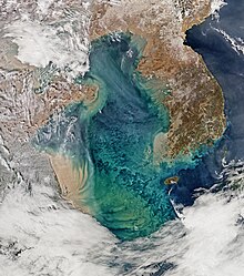
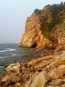
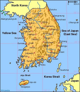
South Korea is located in East Asia, on the southern portion of the Korean Peninsula located out from the far east of the Asian landmass. The only country with a land border to South Korea is North Korea, lying to the north with 238 kilometres (148 mi) of the border running along the Korean Demilitarized Zone. South Korea is mostly surrounded by water and has 2,413 kilometres (1,499 mi) of coast line along three seas; to the west is the Yellow Sea, to the south is the East China Sea, and to the east is the Sea of Japan. Geographically, South Korea's landmass is approximately 100,032 square kilometres (38,623 sq mi). 290 square kilometres (110 sq mi) of South Korea are occupied by water. The approximate coordinates are 37° North, 128° East.

<span class="mw-page-title-main">Yellow River</span> Major river in China

The Yellow River is the second-longest river in China, after the Yangtze River, and the sixth-longest river system on Earth at the estimated length of 5,464 km (3,395 mi). Originating at an elevation above 15,000 feet in the Bayan Har Mountains, it empties into the Bohai Sea. The Yellow River's basin was the birthplace of ancient Chinese civilization.

<span class="mw-page-title-main">Sea of Japan</span> Marginal sea between Japan, Russia and Korea

The Sea of Japan(see below for other names) is the marginal sea between the Japanese archipelago, Sakhalin, the Korean Peninsula, and the mainland of the Russian Far East. The Japanese archipelago separates the sea from the Pacific Ocean. Like the Mediterranean Sea, it has almost no tides due to its nearly complete enclosure from the Pacific Ocean. This isolation also affects faunal diversity and salinity, both of which are lower than in the open ocean. The sea has no large islands, bays or capes. Its water balance is mostly determined by the inflow and outflow through the straits connecting it to the neighboring seas and the Pacific Ocean. Few rivers discharge into the sea and their total contribution to the water exchange is within 1%.

<span class="mw-page-title-main">Bay of Fundy</span> Bay on the east coast of North America

The Bay of Fundy is a bay between the Canadian provinces of New Brunswick and Nova Scotia, with a small portion touching the U.S. state of Maine. It is an arm of the Gulf of Maine. Its tidal range is the highest in the world. The name is probably a corruption of the French word fendu, meaning 'split'.

<span class="mw-page-title-main">Bohai Bay</span>

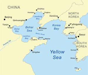
Bohai Bay is one of the three major bays of the Bohai Sea, the northwestern and innermost gulf of the Yellow Sea. It is bounded by the coastlines of eastern Hebei province, Tianjin municipality and northern Shandong province south of the Daqing River estuary and north of the Yellow River estuary. It is the most southerly water in the northern hemisphere where sea ice can form.

<span class="mw-page-title-main">Moreton Bay</span> Inlet in southern Queensland, Australia

Moreton Bay is a bay located on the eastern coast of Australia 14 kilometres (8.7 mi) from central Brisbane, Queensland. It is one of Queensland's most important coastal resources. The waters of Moreton Bay are a popular destination for recreational anglers and are used by commercial operators who provide seafood to market.

<span class="mw-page-title-main">Bryde's whale</span> Species of mammal

Bryde's whale, or the Bryde's whale complex, putatively comprises three species of rorqual and maybe four. The "complex" means the number and classification remains unclear because of a lack of definitive information and research. The common Bryde's whale is a larger form that occurs worldwide in warm temperate and tropical waters, and the Sittang or Eden's whale is a smaller form that may be restricted to the Indo-Pacific. Also, a smaller, coastal form of B. brydei is found off southern Africa, and perhaps another form in the Indo-Pacific differs in skull morphology, tentatively referred to as the Indo-Pacific Bryde's whale. The recently described Omura's whale, was formerly thought to be a pygmy form of Bryde's, but is now recognized as a distinct species. Rice's whale, which makes its home solely in the Gulf of Mexico, was once considered a distinct population of Bryde's whale, but in 2021 it was described as a separate species.

<span class="mw-page-title-main">Mudflat</span> Coastal wetlands where sediments have been deposited by tides or rivers

Mudflats or mud flats, also known as tidal flats or, in Ireland, slob or slobs, are coastal wetlands that form in intertidal areas where sediments have been deposited by tides or rivers. A global analysis published in 2019 suggested that tidal flat ecosystems are as extensive globally as mangroves, covering at least 127,921 km2 (49,391 sq mi) of the Earth's surface. They are found in sheltered areas such as bays, bayous, lagoons, and estuaries; they are also seen in freshwater lakes and salty lakes alike, wherein many rivers and creeks end. Mudflats may be viewed geologically as exposed layers of bay mud, resulting from deposition of estuarine silts, clays and aquatic animal detritus. Most of the sediment within a mudflat is within the intertidal zone, and thus the flat is submerged and exposed approximately twice daily.

<span class="mw-page-title-main">Leizhou Peninsula</span> Peninsula in Guandong, China

The Leizhou Peninsula, alternately romanized as the Luichow Peninsula, is a peninsula in the southernmost part of Guangdong province in South China. As of 2015, the population of the peninsula was 5,694,245. The largest city by population and area on the peninsula, was Zhanjiang.

<span class="mw-page-title-main">Chilika Lake</span> Lagoon in India

Chilika Lake is the largest brackish water lagoon in Asia and second largest coastal lagoon in the world, spread over the Puri, Khordha and Ganjam districts of Odisha state on the east coast of India, at the mouth of the Daya River, flowing into the Bay of Bengal, covering an area of over 1,100 square kilometres (420 sq mi).

<span class="mw-page-title-main">Sundarbans National Park</span> National park and nature reserve in West Bengal, India

The Sundarbans National Park is a national park, tiger reserve and biosphere reserve in West Bengal, India. It is part of the Sundarbans on the Ganges Delta and adjacent to the Sundarban Reserve Forest in Bangladesh. It is located to south-west of Bangladesh. The delta is densely covered by mangrove forests, and is one of the largest reserves for the Bengal tiger. It is also home to a variety of bird, reptile and invertebrate species, including the salt-water crocodile. The present Sundarban National Park was declared as the core area of Sundarban Tiger Reserve in 1973 and a wildlife sanctuary in 1977. On 4 May 1984 it was declared a national park. It is a UNESCO World Heritage Site inscribed in 1987, and it has been designated as a Ramsar site since 2019. It is considered as a World Network of Biosphere Reserve from 1989.

<span class="mw-page-title-main">Spoon-billed sandpiper</span> Species of bird

The spoon-billed sandpiper is a small wader which breeds on the coasts of the Bering Sea and winters in Southeast Asia. This species is highly threatened, and it is said that since the 1970s the breeding population has decreased significantly. By 2000, the estimated breeding population of the species was 350–500.

<span class="mw-page-title-main">Saemangeum</span> Tidal flat in South Korea

Saemangeum is an estuarine tidal flat on the coast of the Yellow Sea in South Korea. It was dammed by the government of South Korea's Saemangeum Seawall Project, completed in 2006, after a long fight between the government and environmental activists, and is scheduled to be converted into either agricultural or industrial land. Prior to 2010, it had played an important role as a habitat for migratory birds.

<span class="mw-page-title-main">Saemangeum Seawall</span> Worlds longest man-made dyke

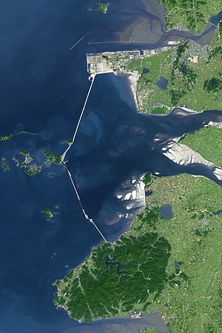
The Saemangeum Seawall, on the south-west coast of the Korean peninsula, is the world's longest man-made dyke, measuring 33 kilometres (21 mi). It runs between two headlands, and separates the Yellow Sea and the former Saemangeum estuary.

<span class="mw-page-title-main">East Asian–Australasian Flyway</span>

The East Asian–Australasian Flyway is one of the world's great flyways of migratory birds. At its northernmost it stretches eastwards from the Taimyr Peninsula in Russia to Alaska. Its southern end encompasses Australia and New Zealand. Between these extremes the flyway covers much of eastern Asia, including China, Japan, Korea, South-East Asia and the western Pacific. The EAAF is home to over 50 million migratory water birds from over 250 different populations, including 32 globally threatened species and 19 near threatened species. It is especially important for the millions of migratory waders or shorebirds that breed in northern Asia and Alaska and spend the non-breeding season in South-East Asia and Australasia.

<span class="mw-page-title-main">Wildlife of China</span> Overview of the wildlife of China

China's vast and diverse landscape is home to a profound variety and abundance of wildlife. As of one of 17 megadiverse countries in the world, China has, according to one measure, 7,516 species of vertebrates including 4,936 fish, 1,269 bird, 562 mammal, 403 reptile and 346 amphibian species. In terms of the number of species, China ranks third in the world in mammals, eighth in birds, seventh in reptiles and seventh in amphibians.

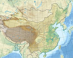
China’s coastline covers approximately 14,500 km from the Bohai gulf in the north to the Gulf of Tonkin in the south. Most of the northern half is low lying, although some of the mountains and hills of Northeast China and the Shandong Peninsula extend to the coast. The southern half is more irregular. In Zhejiang and Fujian provinces, for example, much of the coast is rocky and steep. South of this area the coast becomes less rugged: Low mountains and hills extend more gradually to the coast, and small river deltas are common.

Birds Korea is an organisation dedicated to the conservation of birds and their habitats in South Korea and the wider Yellow Sea Eco-region.

<span class="mw-page-title-main">Fishing industry in China</span>

China has one-fifth of the world's population and accounts for one-third of the world's reported fish production as well as two-thirds of the world's reported aquaculture production. It is also a major importer of seafood and the country's seafood market is estimated to grow to a market size worth US$53.5 Billion by 2027.
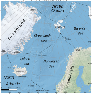
<span class="mw-page-title-main">Bohai Sea</span> The innermost gulf of the Yellow Sea and Korea Bay on the coast of Northeastern and North China

The Bohai Sea is a gulf/inland sea approximately 77,000 km2 (30,000 sq mi) in area on the east coast of Mainland China. It is the northwestern and innermost extension of the Yellow Sea, to which it connects to the east via the Bohai Strait. It has a mean depth of approximately 18 meters (59 ft), with a maximum depth of about 80 meters (260 ft) located in the northern part of the Bohai Strait.

References

  1. 1 2 "Koreas halt all 'hostile' military acts near border". November 2018.
  2. "Limits of Oceans and Seas" (PDF) (3rd ed.). International Hydrographic Organization. 1953. Retrieved 28 December 2020.
  3. Sediments and Phytoplankton bloom near the Mouth of the Yangtze, East China Sea Archived 30 June 2010 at the Wayback Machine , NASA, 2002
  4. 1 2 3 4 Yellow Sea, Great Soviet Encyclopedia (in Russian)
  5. 1 2 3 4 5 6 7 8 Yellow Sea, Encyclopædia Britannica on-line
  6. "A yellow sea". WWF.
  7. Niu, Yaoling; Tang, Jie (2016). "Origin of the Yellow Sea: an insight" (PDF). Science Bulletin. 61 (14): 1076–1080. Bibcode:2016SciBu..61.1076N. doi:10.1007/s11434-016-1113-z. S2CID   132284722.
  8. "The Seas of Korea". Korean Literature Now (in Korean). Archived from the original on 9 July 2021. Retrieved 29 March 2021.
  9. Sand storm over Yellow Sea, nasa.gov
  10. M. J. King, et al. Twinning of Jindo Grand Bridge, Republic of Korea in Current and future trends in bridge design, construction and maintenance 2: safety, economy, sustainability and aesthetics; proceedings of the international conference organized by the Institution of Civil Engineers and held in Hong Kong on 25–26 April 2001 ISBN   0-7277-3091-6 pp. 175, 177
  11. The Moses Miracle Of Jindo Island Archived 27 November 2020 at the Wayback Machine , 17 July 2010
  12. Майские фестивали в Чолладо – от "чуда Моисея" до боя быков Archived 31 July 2009 at the Wayback Machine (in Russian)
  13. Jindo Mysterious Sea Road Archived 3 March 2012 at the Wayback Machine , Jindo County
  14. Bar-tailed Godwit Updates Archived 20 February 2013 at the Wayback Machine , USGS
  15. Chikuni, pp. 8, 16, 19
  16. esa. "Earth from Space: The Yellow Sea of China".
  17. Maurice L. Schwartz (2005) Encyclopedia of coastal science, ISBN   1-4020-1903-3 p. 60
  18. Barter, M.A. (2002). Shorebirds of the Yellow Sea – importance, threats and conservation status. Wetlands International Global Series Vol. 9. International Wader Studies Vol. 12. Canberra ISBN   90-5882-009-2
  19. Barter, M.A. (2005). Yellow Sea – driven priorities for Australian shorebird researchers. pp. 158–160 in: "Status and Conservation of Shorebirds in the East Asian – Australasian Flyway". Proceedings of the Australasian Shorebird Conference, 13–15 December 2003, Canberra, Australia. International Wader Studies 17. Sydney.
  20. Saemangeum and the Saemangeum Shorebird Monitoring Program (SSMP) 2006–2008, Birds Korea
  21. 1 2 3 Murray, Nicholas J.; Clemens, Robert S.; Phinn, Stuart R.; Possingham, Hugh P.; Fuller, Richard A. (2014). "Tracking the rapid loss of tidal wetlands in the Yellow Sea" (PDF). Frontiers in Ecology and the Environment. 12 (5): 267–72. doi:10.1890/130260.
  22. David Lindenmayer, Mark Burgman, Mark A. Burgman (2005) Practical conservation biology, ISBN   0-643-09089-4 p. 172
  23. Weller, D.; et al. (2023). "The western gray whale: a review of past exploitation, current status and potential threats". J. Cetacean Res. Manage. 4 (1): 7–12. doi: 10.47536/jcrm.v4i1.861 . S2CID   35795229 . Retrieved 10 March 2016.
  24. Berzin A.; Ivashchenko V.Y.; Clapham J.P.; Brownell L. R.Jr. (2008). "The Truth About Soviet Whaling: A Memoir". DigitalCommons@University of Nebraska - Lincoln. Retrieved 10 March 2016.
  25. "Distribution of Whales and Dolphins in Korean Waters Based on a Sighting Survey from 2000 to 2010" (PDF). ocean.kisti.re.kr. Retrieved 19 September 2020.
  26. "A Gray Area: On the Matter of Gray Whales in the Western North Pacific (PDF Download Available)". ResearchGate.
  27. Mizroach A.S.. Rice W.D.. Zwiefelhoffer D.. Waite J.. Perryman L.W.. 2009. Distribution and movements of fin whales in the North Pacific Ocean. on The Wiley Online Library. Retrieved on 3 January. 2015
  28. "我国沿海鲸类(–)– – 须鲸篇(下)_科学公园_传送门". chuansong.me.
  29. Monsarrat Sophie (2016). "A spatially explicit estimate of the prewhaling abundance of the endangered North Atlantic right whale". Conservation Biology. 30 (4): 783–791. doi:10.1111/cobi.12664. PMID   26632250. S2CID   3795740.
  30. "长海又现鲸鱼 这回是好几条". Archived from the original on 9 June 2016.
  31. 大连长海又见鲸鱼 – 家亲!三条!四条 Archived 2 June 2016 at the Wayback Machine
  32. Huogen W.; Yu W. (1998). "A Baird's Beaked Whale From the East China Sea". Fisheries Science, 1998-05: CNKI – The China National Knowledge Infrastructure. Retrieved 7 September 2015.
  33. "Yellow Sea | WWF". Archived from the original on 10 March 2016. Retrieved 10 March 2016.
  34. Mr.Z. Charlie. 2008. 我国的渤海里有没有鲸鱼 on Sogou – Wenwen. Retrieved on 3 January. 2015
  35. "백령도 어부들의 친구 쇠돌고래".
  36. "백상아리, 백령도서 물범 공격장면 국내 첫 포착 – 민중의소리". www.vop.co.kr.
  37. 1 2 Population Density Archived 22 July 2010 at the Wayback Machine , NASA, 1994
  38. Chikuni, p. 25
  39. AFP, Agence France-Presse (22 November 2016). "China's jellyfish-hauling mules a dying breed". www.atimes.com. Retrieved 2 December 2016.
  40. Fishing Industry Archived 27 May 2010 at the Wayback Machine , noaa.gov
  41. Chikuni, pp. 37, 47, 55
  42. Ferry sinks in Yellow Sea, killing hundreds, 24 November 1999
  43. China found new large oil field in the Yellow Sea, News.ru, 3 May 2007 (in Russian)
  44. China's worst-ever oil spill threatens wildlife as volunteers assist in clean-up, Guardian, 21 July 2010
  45. 1 2 3 UNDP/GEF. (2007) The Yellow Sea: Analysis of Environmental Status and Trends. p. 408, Ansan, Republic of Korea.
  46. 1 2 Murray, Nicholas J.; Ma, Zhijun; Fuller, Richard A. (2015). "Tidal flats of the Yellow Sea: A review of ecosystem status and anthropogenic threats" (PDF). Austral Ecology. 40 (4): 472–481. doi: 10.1111/aec.12211 . ISSN   1442-9985.
  47. Liang Bin (2019). "Report on Marine Environmental Status and Trends of the Yellow Sea" (PDF).
  48. "China's largest algal bloom turns the Yellow Sea green". The Guardian.

Bibliography

Yellow Sea
Bohaiseamap2.png