
Gyeonggi-do is the most populous province in South Korea.
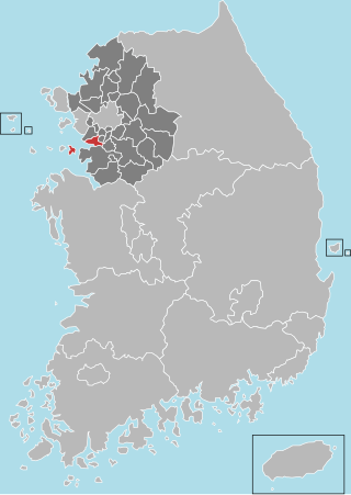
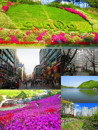
Ansan is a city in Gyeonggi Province, South Korea. It lies southwest of Seoul and is part of the Seoul National Capital Area. It is connected to Seoul by rail via Seoul Subway Line 4. It is situated on the Yellow Sea coast and some islands lie within its jurisdiction. The largest and best-known of these is Daebu Island.

Anseong is a city in Gyeonggi Province, South Korea, 80 kilometres (50 mi) south of Seoul. Its geographical location is 37°0′N127°16′E.
Gunpo, formerly romanized as Kunp'o, is a small city in South Korea's Gyeonggi Province, located south of Seoul in the Seoul National Capital Area. It borders Anyang to the north, Uiwang to the east, and Ansan to the south and west, and is connected to its neighbors and to Seoul by lines 1 and 4 of the Seoul Metropolitan Subway. Gunpo is also home to three stops on the Gyeongbu Line, a national railway that links it to the rest of the country. Although 73.2% of the city is greenspace, owing largely to Surisan and various smaller mountains, Gunpo is home to over 286,000 residents in several urban areas. The city's downtown core is Sanbon New Town, a commercial hub which centers on a pedestrian "street of culture" that Gunpo has designated as one of its eight scenic locations.

Paju is a city in Gyeonggi Province, South Korea. Paju was made a city in 1997; it had previously been a county (gun).

Uiwang is a city in Gyeonggi Province, South Korea. It is one of many satellite cities that ring Seoul, making up the Seoul Capital Area. Its largest immediate urban neighbor is Anyang. The low peaks of the Gwangju Mountains shape the local landscape.
English villages are language education institutions which aim to create a language immersion environment for students of English in their own country.
Ansan University (Korean: 안산대학교) is a 3,4-year university located in Ansan City, Gyeonggi province, South Korea. It hosts a student body of about four thousand, and offers programs in fields including nursing, physiotherapy, early childhood education, and information technology. The school was originally named Ansan 1 University.

Geumjeong Station is a ground-level metro station on lines 1 and 4 of the Seoul Subway network in South Korea. The station is in Gunpo, a city approximately 15 km (9.3 mi) south of Seoul in Gyeonggi Province, between the cities of Anyang and Suwon. The name means that the land is covered with waves everywhere and that the water wets women's clothes.

Bupyeong District is one of the 10 administrative divisions that comprise Incheon, South Korea. Bupyeong District comprises an area of 12.35 square miles, and has a population of 508,587. It is located north of Namdong District, east of Seo District, and south of Gyeyang District. The city of Bucheon, in neighboring Gyeonggi Province, comprises its eastern limit.

Oido station is a subway station on Seoul Subway Line 4 and the Suin–Bundang Line in Siheung, South Korea. It is the current southwestern terminus of Seoul Subway Line 4 located almost 30 kilometers southwest of Seoul, connecting Oido to other parts of Korea. A commuter rail trip between this station and Seoul Station takes over an hour, and a train servicing depot is located nearby. The name of the station was decided by the surrounding area Oido island.
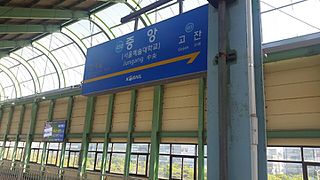
Jungang Station is a railway station on Seoul Subway Line 4 and the Suin–Bundang Line in Ansan, South Korea. Its substation name is Seoul Institute of the Arts. It is a busy station located close to the Ansan Express Bus Terminal.

Yeongheung Island (Korean: 영흥도) is an island in the Yellow Sea, within the municipal borders of Incheon metropolitan city. It has a population of roughly 4000 people and an area of 23.46 km2. The island is connected by road to neighbouring Seonjae-do (선재도) by the 1.25 km-long Yeongheung Bridge, which opened in December 2001. Administratively, the island today is divided into ten li: Nae-ri (내리) 1 to 7, and Oi-ri (외리) 1 to 3. Employment is provided through tourism, fishing, and the thermoelectric power station, largely built on reclaimed land on the south-west coast of the island.
Bongdam is a town in the city of Hwaseong in South Korea. Covering over 4000 hectares, the town is the focus of a planned community, primarily as a commuter town for the bordering city of Suwon.

Ipbuk-dong is an administrative neighbourhood in Gwonseon-gu, Suwon, Gyeonggi Province, South Korea. Ipbuk-dong is divided into two different legal-status neighbourhoods, namely Ipbuk-dong and Dangsu-dong, which are separated by the Hwanggujicheon—a stream which flows south from Wangsong Reservoir on their northern boundary with the city of Uiwang, through Suwon, eventually to Asan Bay. Dangsu-dong has Suwon's sole boundary with Ansan, and meets Hwaseong further south. The neighbourhood is 96% green belt.

Choji-dong is dong (neighborhood) of Danwon District, Ansan, Gyeonggi Province, South Korea. Located in the center of the city, it is formed as a residential, green, and industrial complex area, and with the creation of Gojan New Town, the population is rapidly increasing, centering on new apartments. Banwol Industrial Complex and Sihwa Industrial Complex, where the largest small and medium-sized enterprise complex in Korea is built, are included in Choji-dong, Korea, and have a large image as an industrial area. Choji-dong is the heart of the national industry with Banwol National Industrial Complex, which houses more than 2,000 small and medium-sized enterprises. In addition to residents in the jurisdiction, there are Hwarang Recreation Area where many people gather to relax and Citizens Market, a traditional market where the 5-day market is active.
Hosu-dong is dong (neighborhood) of Danwon District, Ansan, Gyeonggi Province, South Korea. It is located in the center of the new city according to the second stage development plan of the new city in Ansan. It is a residential city where large-scale apartment and general housing are combined, and has various urban structures where education, culture, commerce, and business facilities are concentrated.
Ansan-dong is a neighbourhood of Sangnok District, Ansan, Gyeonggi Province, South Korea.

Oido is an area in Siheung, Gyeonggi Province, South Korea. As its name suggests, it was previously an island, but land reclamation projects in the 20th century led to it eventually joining the mainland.

Pungdo or Pung Island, is a small populated island on the Yellow Sea, located in within the municipal borders of Ansan, Gyeonggi Province, South Korea. It is about 74 km southwest of Seoul, the country's capital, and 24 km south of the larger island Daebudo.


