Ancient pre-Columbian kingdom in Guanacaste, Costa Rica
You can help expand this article with text translated from the corresponding article in Spanish. (June 2025)Click [show] for important translation instructions.
View a machine-translated version of the Spanish article.
Machine translation, like DeepL or Google Translate, is a useful starting point for translations, but translators must revise errors as necessary and confirm that the translation is accurate, rather than simply copy-pasting machine-translated text into the English Wikipedia.
Consider adding a topic to this template: there are already 1,123 articles in the main category, and specifying|topic= will aid in categorization.
Do not translate text that appears unreliable or low-quality. If possible, verify the text with references provided in the foreign-language article.
You must provide copyright attribution in the edit summary accompanying your translation by providing an interlanguage link to the source of your translation. A model attribution edit summary is Content in this edit is translated from the existing Spanish Wikipedia article at [[:es:Reino de Nicoya]]; see its history for attribution.
You may also add the template {{Translated|es|Reino de Nicoya}} to the talk page.
The Kingdom of Nicoya (from Nahuatl: Nekok Yaotl), also called Cacicazgo or Lordship of Nicoya, was an indigenous nation that comprised much of the territory of the current Guanacaste Province, in the North Pacific of Costa Rica. Its political, economic and religious center was the city of Nicoya, located on the peninsula of the same name, which depends on several provinces located on both banks of the Gulf of Nicoya, as well as numerous tributary villages. In the 16th century, prior to the arrival of Europeans, Nicoya was the most important chiefdom of the North Pacific of present-day Costa Rica.[1]
The Nicoya region is located on the southern border of Mesoamerica,[2] when it was occupied in 800 AD. C. by immigrant groups that come from the north, from the Valley of Mexico, and that have been under the domination of the Olmecs. These groups, known as Chorotegas, are installed in the Isthmus of Rivas, in Nicaragua, and much of the territory of Guanacaste, especially the Nicoya Peninsula, displacing cultural groups from the Intermediate Area. The successive entrances of the Nicaraos, the Rivas Isthmus, produced, in turn, the Chorotegas moved and occupied, the islands and the eastern band of the Gulf of Nicoya, which caused them to come into contact and exert cultural influence on the groups of Native Americans from central and southern Costa Rica, which are located in the Mesoamerica area, but without eliminating local bases.
History
In archaeological terms, the territory of Guanacaste is part of the archeological region of Greater Nicoya, which extends from the Gulf of Fonseca in Honduras, covering the entire Pacific of Nicaragua, to the northern Pacific of Costa Rica. The Greater Nicoya has been divided, for its study, into two subregions: the northern or Nicaraguan subregion (Nicaragua Pacific) and the southern subregion or Guanacaste (Nicoya Peninsula, the Tempisque river basin, the piedmont and the highlands of the Guanacaste and Tilarán mountain ranges in Costa Rica). In this last subregion is the Kingdom of Nicoya.[3]
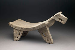
In the Greater Nicoya there was a constituted cultural center that flourished for approximately 2000 years.[4][5] Archaeological research shows that the Nicoyan society achieved a complex social organization and a high degree of cultural development. Upon the arrival of the Spaniards into Nicoya in the 16th century, they found complex cities and governments, specialized agriculture that included irrigation, arts and crafts, highlighting the triad of polychrome ceramics (whose tradition has been inherited by Guanacastecan artisans to this day), the making of jewelry from jade and the manufacture of stone metates, with various regional styles. For 1200 years, the Nicoyan cultural tradition in Guanacaste was clearly established as a distinctive entity.[6][7]
Name
Nicoya was the name of the monarch who ruled this nation at the time of contact with the Europeans. As it happened with most of the cacicazgos in Costa Rican soil, the Spaniards gave the territory the name of their ruler. This king has been called Nicoa, Nicoya, Nicoián or Nicoyán, etc., the word seems to be a Hispanicization of an indigenous name.[8][9]
Several theories have been given about the meaning of the word Nicoya. One of the meanings is that Nicoya comes from the Nahuatl word Necoclau, from necoc, "on both sides," and lau, "sea," denoting the peninsular condition of the region ("country with water on both sides"). Another theory says that Nicoya was actually the name by which the Nicoyan kings were called, and that it comes from the Nahuatl Necoc Yáotl, “with enemies on both sides,” since the Chorotegas had constant warlike conflicts with their northern neighbors, the Nicarao people, the huetarGarabito Empire located to the east, and with the aborigines of the Chira Island, who disputed control of the peninsula and the gulf. Necoc Yáotl is also an invocation of the Mesoamerican god Tezcatlipoca, who in the Mesoamerican cosmogony was, among other characteristics, the god of the battles, and whom the chorotegas and all the Nahua peoples worshiped.1 One of the ways to represent Tezcatlipoca was the jaguar or jaguar-man (Tepeyollotl), a frequent theme in Nicoyan art.
Nicoya had an elective monarchy as the ruler named by the Spanish cacique (generic term for all pre-Hispanic monarchs, but Caribbean in origin) whose name in Mangue was mánkeme, and was appointed by a Council of Elders named monexico. A system of feudal lords known as galpones ruled a federation of city-states or chiefdoms.[10]
This page is based on this Wikipedia article Text is available under the CC BY-SA 4.0 license; additional terms may apply. Images, videos and audio are available under their respective licenses.