
The history of Oceania includes the history of Australia, Easter Island, Fiji, Hawaii, New Zealand, Papua New Guinea, Western New Guinea and other Pacific island nations.

Oceania is a geographical region comprising Australasia, Melanesia, Micronesia, and Polynesia. Spanning the Eastern and Western Hemispheres, at the centre of the water hemisphere, Oceania is estimated to have a land area of about 9,000,000 square kilometres (3,500,000 sq mi) and a population of around 44.4 million as of 2022. When compared to the other continents, Oceania is the smallest in land area and the second-least populated after Antarctica.

Melanesia is a subregion of Oceania in the southwestern Pacific Ocean. It extends from New Guinea in the west to the Fiji Islands in the east, and includes the Arafura Sea.

The Australasian realm is one of eight biogeographic realms that is coincident with, but not the same as, the geographical region of Australasia. The realm includes Australia, the island of New Guinea, and the eastern part of the Indonesian archipelago, including the island of Sulawesi, the Moluccas, and the islands of Lombok, Sumbawa, Sumba, Flores, and Timor, often known as the Lesser Sundas.

Pacific Islanders, Pasifika, Pasefika, Pacificans or rarely Pacificers are the peoples of the Pacific Islands. As an ethnic/racial term, it is used to describe the original peoples—inhabitants and diasporas—of any of the three major subregions of Oceania.
Polynesians are an ethnolinguistic group of closely related ethnic groups who are native to Polynesia, an expansive region of Oceania in the Pacific Ocean. They trace their early prehistoric origins to Island Southeast Asia and form part of the larger Austronesian ethnolinguistic group with an Urheimat in Taiwan. They speak the Polynesian languages, a branch of the Oceanic subfamily of the Austronesian language family. The Indigenous Māori people constitute the largest Polynesian population, followed by Samoans, Native Hawaiians, Tahitians, Tongans and Cook Islands Māori.

The Lapita culture is the name given to a Neolithic Austronesian people and their distinct material culture, who settled Island Melanesia via a seaborne migration at around 1600 to 500 BCE. The Lapita people are believed to have originated from the northern Philippines, either directly, via the Mariana Islands, or both. They were notable for their distinctive geometric designs on dentate-stamped pottery, which closely resemble the pottery recovered from the Nagsabaran archaeological site in northern Luzon. The Lapita intermarried with the Papuan populations to various degrees, and are the direct ancestors of the Austronesian peoples of Polynesia, eastern Micronesia, and Island Melanesia.

Malesia is a biogeographical region straddling the Equator and the boundaries of the Indomalayan and Australasian realms, and also a phytogeographical floristic region in the Paleotropical Kingdom. The original definition by the World Geographical Scheme for Recording Plant Distributions included Papuasia, but this was split off in its 2001 version.

Wallacea is a biogeographical designation for a group of mainly Indonesian islands separated by deep-water straits from the Asian and Australian continental shelves. Wallacea includes Sulawesi, the largest island in the group, as well as Lombok, Sumbawa, Flores, Sumba, Timor, Halmahera, Buru, Seram, and many smaller islands. The islands of Wallacea lie between the Sunda Shelf to the west, and the Sahul Shelf including Australia and New Guinea to the south and east. The total land area of Wallacea is 347,000 km2 (134,000 sq mi).

Melanesians are the predominant and indigenous inhabitants of Melanesia, in an area stretching from New Guinea to the Fiji Islands. Most speak one of the many languages of the Austronesian language family or one of the many unrelated families of Papuan languages. There are several creoles of the region, such as Tok Pisin, Hiri Motu, Solomon Islands Pijin, Bislama, and Papuan Malay.

The approximately 450 Oceanic languages are a branch of the Austronesian languages. The area occupied by speakers of these languages includes Polynesia, as well as much of Melanesia and Micronesia. Though covering a vast area, Oceanic languages are spoken by only two million people. The largest individual Oceanic languages are Eastern Fijian with over 600,000 speakers, and Samoan with an estimated 400,000 speakers. The Gilbertese (Kiribati), Tongan, Tahitian, Māori and Tolai languages each have over 100,000 speakers. The common ancestor which is reconstructed for this group of languages is called Proto-Oceanic.
The indigenous peoples of Oceania are Aboriginal Australians, Papuans, and Austronesians. These indigenous peoples have a historical continuity with pre-colonial societies that developed on their territories. With the notable exceptions of Australia, New Zealand, Hawaii, New Caledonia, Guam, and Northern Mariana Islands, indigenous peoples make up the majority of the populations of Oceania.
Geologically, the Sahul Shelf is a part of the continental shelf of the Australian continent, lying off the northwest coast of mainland Australia.

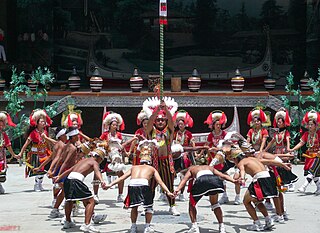
Oceanic art or Oceanian art comprises the creative works made by the native people of the Pacific Islands and Australia, including areas as far apart as Hawaii and Easter Island. Specifically it comprises the works of the two groups of people who settled the area, though during two different periods. They would in time however, come to interact and together reach even more remote islands. The area is often broken down into four separate regions: Micronesia, Melanesia, Polynesia and Australia. Australia, along with interior Melanesia (Papua), are populated by descendants of the first waves of human migrations into the region by Australo-Melanesians. Micronesia, Island Melanesia, and Polynesia, on the other hand, are descendants of later Austronesian voyagers who intermixed with native Australo-Melanesians; mostly via the Neolithic Lapita culture. All of the regions in later times would be greatly affected by western influence and colonization. In more recent times, the people of Oceania have found a greater appreciation of their region's artistic heritage.
The Austronesian peoples, sometimes referred to as Austronesian-speaking peoples, are a large group of peoples in Taiwan, Maritime Southeast Asia, parts of Mainland Southeast Asia, Micronesia, coastal New Guinea, Island Melanesia, Polynesia, and Madagascar that speak Austronesian languages. They also include indigenous ethnic minorities in Vietnam, Cambodia, Myanmar, Thailand, Hainan, the Comoros, and the Torres Strait Islands. The nations and territories predominantly populated by Austronesian-speaking peoples are sometimes known collectively as Austronesia.

Polynesia is a subregion of Oceania, made up of more than 1,000 islands scattered over the central and southern Pacific Ocean. The indigenous people who inhabit the islands of Polynesia are called Polynesians. They have many things in common, including language relatedness, cultural practices, and traditional beliefs. In centuries past, they had a strong shared tradition of sailing and using stars to navigate at night.

The Solomon Islands (archipelago) is an island group in the western South Pacific Ocean, north-east of Australia. The archipelago is in the Melanesian subregion and bioregion of Oceania and forms the eastern boundary of the Solomon Sea. The many islands of the archipelago are distributed across the sovereign states of Papua New Guinea and Solomon Islands. The largest island in the archipelago is Bougainville Island, which is a part of the Autonomous Region of Bougainville along with Buka Island, the Nukumanu Islands, and a number of smaller nearby islands. Much of the remainder falls within the territory of Solomon Islands and include the atolls of Ontong Java, Sikaiana, the raised coral atolls of Bellona and Rennell, and the volcanic islands of Choiseul, Guadalcanal, Makira, Malaita, New Georgia, the Nggelas, Santa Isabel, and the Shortlands. The Santa Cruz Islands are not a part of the archipelago.
Island Melanesia is a subregion of Melanesia in Oceania.
Sahul, also called Sahul-land, Meganesia, Papualand and Greater Australia, was a paleocontinent that encompassed the modern-day landmasses of mainland Australia, Tasmania, New Guinea, and the Aru Islands.
