
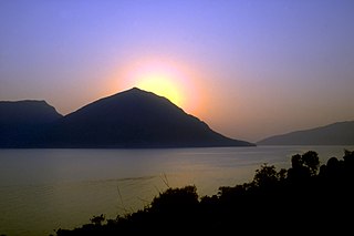
Icaria, also spelled Ikaria, is a Greek island in the Aegean Sea, 10 nautical miles (19 km) southwest of Samos.

Leros, also called Lero, is a Greek island and municipality in the Dodecanese in the southern Aegean Sea. It lies 317 kilometres from Athens's port of Piraeus, from which it can be reached by a nine-hour ferry ride or by a 45-minute flight from Athens. It is about 32 kilometres from Turkey. Leros is part of the Kalymnos regional unit. It has a population of 7,992 (2021).

Akrata, is a town and a former municipality in Achaea, West Greece, Greece. Since the 2011 local government reform it is part of the municipality Aigialeia, of which it is a municipal unit. The municipal unit has an area of 180.169 km2. Akrata is located on the right bank of the river Krathis, 3 km from its outflow into the Gulf of Corinth. The Greek National Road 8A/E65 and the railway from Patras to Corinth pass through the municipal unit, northeast of the town. The nearest town is Aigeira, 4 km to the east. It is 23 km southeast of Aigio, 52 km east of Patras and 23 km northeast of Kalavryta.

Amorgos is the easternmost island of the Cyclades island group and the nearest island to the neighboring Dodecanese island group in Greece. Along with 16 neighbouring islets, the largest of which is Nikouria Island, it comprises the municipality of Amorgos, which has a land area of 126.346 square kilometres and at the 2021 census had a population of 1,961.

Archangelos is a town and a former municipality on the island of Rhodes, in the Dodecanese, Greece. Since the 2011 local government reform it is part of the municipality Rhodes, of which it is a municipal unit.

Donousa, and sometimes spelled Donoussa, is an island and a former community in the Cyclades, Greece. Since the 2011 local government reform it is part of the municipality Naxos and Lesser Cyclades, of which it is a municipal unit. Donousa is the easternmost island of the Lesser Cyclades.
Kalamos is a mountainous island and a former community in the Ionian Islands, Greece. Since the 2011 local government reform it is part of the municipality Lefkada, of which it is a municipal unit. It lies east of Lefkada, near the Greek mainland. It has a wintering population of around 500 people, which is swelled substantially in the summer by tourists.

Kimolos is a Greek island in the Aegean Sea. It lies on the southwest of the island group of Cyclades, near the bigger island of Milos. Kimolos is the administrative center of the municipality of Kimolos, which also includes the uninhabited islands of Polyaigos, Agios Efstathios and Agios Georgios. The island has a land area of 36 square kilometres (13.900 sq mi), while the municipality's land area is 53.251 square kilometres (20.560 sq mi), and it reported a population of 810 inhabitants in the 2021 census.

Plomari is a town and a former municipality on the island of Lesbos, North Aegean, Greece. Since the 2019 local government reform it is part of the municipality Mytilene, of which it is a municipal unit. It is the only sizable coastal settlement in the south, and the second largest town on Lesbos. The municipal unit of Plomari is the southernmost on Lesbos Island and has a land area of 122.452 km2 and a 2021 census population of 4,852. Its largest towns or villages are Plomári, the former municipal seat, Plagiá, Palaiochóri, Megalochóri, and Akrási.

Agathonísi is a small Greek island and municipality located at the northernmost point of the Dodecanese in Greece. It is surrounded by many smaller islands and is home to two villages, both inland; Megalo Chorio, and Mikro Chorio. Between them is the small settlement of Agios Georgios, which forms the island's only harbor and consists of a few hotels and restaurants. The island is also locally known as Gaidaro ("Donkey"), or by its ancient name Tragea.

Erikoussa is an island and a former community of the Ionian Islands, Greece. It is one of the Diapontian Islands; an island complex to the northwest of Corfu. Since the 2019 local government reform it is part of the municipality of Central Corfu and Diapontian Islands, of which it is a municipal unit. It is located off the northwestern coast of the island of Corfu, and is almost equidistant from Corfu to the southeast, Mathraki to the southwest, and Othonoi to the west. Its population was 447 in the 2021 census, and its land area is 3.65 square kilometres (1 sq mi). The municipal unit has an area of 4.449 km2. It has six settlements; the main one is Porto (Πόρτο), which is also where the only port is located. The island has dense vegetation and three beaches; Porto (Πόρτο), Bragini (Μπραγκίνι), and Fiki (Φύκι). The name Ereikoussa derives from the plant ereíki (ερείκη), which can be found throughout the island.

Schoinoussa or Schinoussa is an island and a former community in the Cyclades, Greece. Since the 2011 local government reform it is part of the municipality Naxos and Lesser Cyclades, of which it is a municipal unit. It lies south of the island of Naxos, in the Lesser Cyclades group, between the island communities of Irakleia and Koufonisia. The population was 229 inhabitants at the 2021 census. Its land area is 8.512 square kilometres (3.29 sq mi).

Sikinos is a Greek island and municipality in the Cyclades. It is located midway between the islands of Ios and Folegandros. Sikinos is part of the Thira regional unit.

Sami is a town and a municipality on the island of Cephalonia, Ionian Islands, Greece. Since the 2019 local government reform it is one of the three municipalities on the island. It is located on the central east coast of the island. The municipality has an area of 291.2 km2 and the municipal unit has an area of 129.326 km². The 2021 census recorded a population of 2,478 in the municipal unit, and 5,501 in the municipality in its post-2019 extension. Its municipal seat is the town of Sami
Omala is a former community on the island of Kefalonia, Ionian Islands, Greece. Since the 2019 local government reform it is part of the municipality Argostoli, of which it is a municipal unit. It is located in the south-central part of the island. Its land area is 46.699 km² and its population was 748 inhabitants at the 2021 census. The seat of the community was Valsamata, the only significant town. Its next largest settlements are Epanochori and Michata.

Moudros is a town and a former municipality on the island of Lemnos, North Aegean, Greece. Since the 2011 local government reform it is part of the municipality Lemnos, of which it is a municipal unit. It covers the entire eastern peninsula of the island, with a land area of 185.127 km2, covering 38.8% of the island's territory. The municipal seat was the town of Moúdros. Its next largest town is Kontopouli. The municipal unit's total population was 3,398 in the 2021 census.
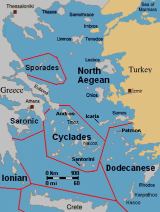
The North Aegean islands are a number of scattered islands in the North Aegean Sea, also known as the Northeastern Aegean islands, belonging mostly to Greece and a few of them to Turkey. The islands do not form a physical chain or group, but are frequently grouped together for tourist or administrative purposes. To the south are the Dodecanese islands; and to the west are the Cyclades and Sporades islands.
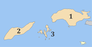
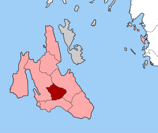
Ikaria is one of the regional units of Greece. It is part of the region of North Aegean. The regional unit covers the island of Ikaria and the small archipelago Fournoi Korseon, in the Aegean Sea.

Agios Minas is a Greek island in Fournoi Korseon cluster. It is located east of Fournoi. Agios Minas is the third largest island of the cluster with an area of 2.5 km2. On the island, only a few shepherds live occasionally. The population of the island is 3 inhabitants according to the 2021 census. Administratively, Agios Minas belongs to Ikaria and Fournoi Korseon municipality.


