
Santorini, officially Thira or Thera, is a Greek island in the southern Aegean Sea, about 200 km (120 mi) southeast from its mainland. It is the largest island of a small, circular archipelago formed by the Santorini caldera. It is the southernmost member of the Cyclades group of islands, with an area of approximately 73 km2 (28 sq mi) and a 2021 census population of 15,480. The municipality of Santorini includes the inhabited islands of Santorini and Therasia, as well as the uninhabited islands of Nea Kameni, Palaia Kameni, Aspronisi and Christiana. The total land area is 90.623 km2 (34.990 sq mi). Santorini is part of the Thira regional unit.

The 3rd millennium BC spanned the years 3000 to 2001 BC. This period of time corresponds to the Early to Middle Bronze Age, characterized by the early empires in the Ancient Near East. In Ancient Egypt, the Early Dynastic Period is followed by the Old Kingdom. In Mesopotamia, the Early Dynastic Period is followed by the Akkadian Empire. In what is now Northwest India and Pakistan, the Indus Valley civilization developed a state society.

Andrew Colin Renfrew, Baron Renfrew of Kaimsthorn, is a British archaeologist, paleolinguist and Conservative peer noted for his work on radiocarbon dating, the prehistory of languages, archaeogenetics, neuroarchaeology, and the prevention of looting at archaeological sites.

Saqqara, also spelled Sakkara or Saccara in English, is an Egyptian village in the markaz (county) of Badrashin in the Giza Governorate, that contains ancient burial grounds of Egyptian royalty, serving as the necropolis for the ancient Egyptian capital, Memphis. Saqqara contains numerous pyramids, including the Pyramid of Djoser, sometimes referred to as the Step Pyramid, and a number of mastaba tombs. Located some 30 km (19 mi) south of modern-day Cairo, Saqqara covers an area of around 7 by 1.5 km.

Milos or Melos is a volcanic Greek island in the Aegean Sea, just north of the Sea of Crete. Milos is the southwestern-most island in the Cyclades group.
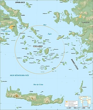
Cycladic culture was a Bronze Age culture found throughout the islands of the Cyclades in the Aegean Sea. In chronological terms, it is a relative dating system for artifacts which is roughly contemporary to Helladic chronology and Minoan chronology (Crete) during the same period of time.

Abusir is the name given to an ancient Egyptian archaeological pyramid complex comprising the ruins of 4 kings' pyramids dating to the Old Kingdom period, and is part of the Pyramid Fields of the Memphis and its Necropolis UNESCO World Heritage Site.

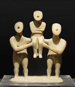
Frying pans is the descriptive nickname for a type of Early Cycladic II artifacts from the Aegean Islands around 2700-2200 BCE. They are flat circular disks with a "handle", and usually made from earthenware, but sometimes stone. They are found especially during the Cycladic Grotta-Pelos and Keros-Syros cultures. Their purpose remains unknown, although they are usually interpreted as prestige goods.
Ftelia is an archaeological site located on a beach on the island of Mykonos, Greece.
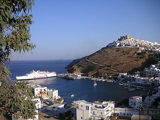
Astypalaia, is a Greek island with 1,334 residents. It belongs to the Dodecanese, an archipelago of fifteen major islands in the southeastern Aegean Sea. However, many scholars recognize Astypalaia as an extension of the Cyclades, as many cultural and ecological components of the island are more indicative of the Cyclades rather than the Dodecanese.

Keros is an uninhabited and unpopulated Greek island in the Cyclades about 10 km (6 mi) southeast of Naxos. Administratively it is part of the community of Koufonisia. It has an area of 15 km2 (6 sq mi) and its highest point is 432 m (1,417 ft). It was an important site to the Cycladic civilization that flourished around 2500 BC. It is now forbidden to land on Keros.

Despotikó, anciently, Prepesinthus or Prepesinthos, is a small, uninhabited Greek island in the Cyclades. It is situated west of the island of Antiparos, and east of the smaller island of Strongyli.

Irakleia or Heraklia is an island and a former community in the Cyclades, Greece. Since the 2011 local government reform it is part of the municipality Naxos and Lesser Cyclades, of which it is a municipal unit. Its population was officially 148 inhabitants at the 2021 census, and its land area 17.795 square kilometres (6.9 sq mi). It is a small island between the islands of Naxos and Ios. Close to Schoinoussa, Koufonisi, Donoussa, and Keros, together they form the Lesser Cyclades. The port is called Agios Georgios, while the "capital"/chora on the top of the island is called Panagia (Madonna). The biggest caves in the Cyclades are located on Irakleia. Irakleia can be reached by ferries from Athens, Naxos and Paros.

Koufonisia are a small island complex and a former community in the Cyclades, Greece. Since the 2011 local government reform it is part of the municipality Naxos and Lesser Cyclades, of which it is a municipal unit. The municipal unit has an area of 26.025 km2.

Phylakopi, located at the northern coast of the island of Milos, is one of the most important Bronze Age settlements in the Aegean and especially in the Cyclades. The importance of Phylakopi is in its continuity throughout the Bronze Age and because of this, it is the type-site for the investigation of several chronological periods of the Aegean Bronze Age.
The Keros-Syros culture is named after two islands in the Cyclades: Keros and Syros. This culture flourished during the Early Cycladic II period of the Cycladic civilization. The trade relations of this culture spread far and wide from the Greek mainland to Crete and Asia Minor.
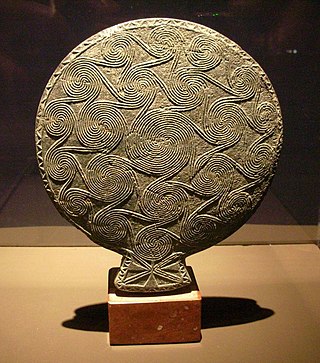
The Cycladian frying pan is an ornately decorated stone object of the type nicknamed as frying pans, from the Bronze Age Cycladic civilization. It dates to the Early Cycladic period, between the 27th and 24th centuries BC. The find spot is unknown, except that it originated on the Cycladic island of Naxos. The item derived from an illegal excavation and was acquired in 1975 by the Baden State Museum in Karlsruhe. On 6 June 2014 it was repatriated to the National Archaeological Museum of Athens, Greece.
The Lesser Cyclades or Small Cyclades is an island complex in the Aegean Sea, inside the archipelago of the Cyclades. It is located to the south-east of Naxos and comprises 32 islands and rocks. The main islands are Ano Koufonisi, Kato Koufonisi, Irakleia, Schoinoussa, Donousa and Keros. The largest of them is Irakleia with an area of 18 km2 and the most populated is Ano Koufonisi with a population of 399, according to the 2011 census. Only four of them are inhabited, Ano Koufonisi, Irakleia, Donousa and Schoinoussa. The islet of Kato Antikeri has also two inhabitants. Administratively, the islands belong to the Naxos and Lesser Cyclades municipality apart from the islets of Ano and Kato Antikeri that belong to Amorgos municipality.

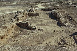
Skarkos is an early Bronze Age settlement on the island of Ios in Greece. Owing to its well preserved state, Skarkos is one of the most important prehistoric sites in the Aegean and especially the Cyclades.
Chalandriani is a major early Bronze Age cemetery on the island of Syros in Greece, dated to the Early Cycladic II period. The fortified prehistoric settlement of Kastri is located north of Chalandriani. Chalandriani was first excavated by the Greek classical archaeologist Christos Tsountas in 1898.

