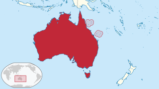
The Coral Sea Islands Territory is an external territory of Australia which comprises a group of small and mostly uninhabited tropical islands and reefs in the Coral Sea, northeast of Queensland, Australia. The only inhabited island is Willis Island. The territory covers 780,000 km2 (301,160 sq mi), most of which is ocean, extending east and south from the outer edge of the Great Barrier Reef and includes Heralds Beacon Island, Osprey Reef, the Willis Group and fifteen other reef/island groups. Cato Island is the highest point in the Territory.

The Manawatāwhi / Three Kings Islands are a group of 13 uninhabited islands about 55 kilometres (34 mi) northwest of Cape Reinga / Te Rerenga Wairua, New Zealand, where the South Pacific Ocean and Tasman Sea converge. They measure 6.85 km2 (2.64 sq mi) in area. The islands are on a submarine plateau, the Three Kings Bank, and are separated from the New Zealand mainland by an 8 km wide, 200 to 300 m deep submarine trough. Therefore, despite relative proximity to the mainland, the islands are listed with the New Zealand Outlying Islands. The islands are an immediate part of New Zealand, but not part of any region or district, but instead Area Outside Territorial Authority, like all the other outlying islands except the Solander Islands.

Mykonos is a Greek island, part of the Cyclades, lying between Tinos, Syros, Paros and Naxos. The island has an area of 85.5 square kilometres (33.0 sq mi) and rises to an elevation of 341 metres at its highest point. There are 10,134 inhabitants according to the 2011 census, most of whom live in the largest town, Mykonos, which lies on the west coast. The town is also known as Chora.

The Bounty Islands are a small group of 13 uninhabited granite islets and numerous rocks, with a combined area of 135 ha, in the South Pacific Ocean. Territorially part of New Zealand, they lie about 670 km (416 mi) east-south-east of New Zealand's South Island, 530 km (329 mi) south-west of the Chatham Islands, and 215 km (134 mi) north of the Antipodes Islands. The group is a World Heritage Site.

The Columbretes Islands (Valencian: Les Columbretes, IPA: [les kolumˈbɾetes] or Els Columbrets, are a group of small uninhabited islets of volcanic origin, in the Mediterranean Sea, 49 kilometres off Orpesa. Administratively they belong to Castellón de la Plana in the Valencian Community.

Kimolos is a Greek island in the Aegean Sea. It lies on the southwest of the island group of Cyclades, near the bigger island of Milos. Kimolos is the administrative center of the municipality of Kimolos, which also includes the uninhabited islands of Polyaigos, Agios Efstathios and Agios Georgios. The island has a land area of 36 square kilometres (13.900 sq mi), while the municipality's land area is 53.251 square kilometres (20.560 sq mi), and it reported a population of 910 inhabitants in the 2011 census.
Kalpeni is an inhabited Atoll in the Union Territory of Lakshadweep, India. It has a distance of 287 km (178 mi) west of the city of Kochi.

Keros (Greek: Κέρος; anciently, Keria or Kereia is an uninhabited Greek island in the Cyclades about 10 km southeast of Naxos. Administratively it is part of the community of Koufonisia. It has an area of 15 km2 and its highest point is 432 m. It was an important site to the Cycladic civilization that flourished around 2500 BC. It is now forbidden to land in Keros.

Morda is an uninhabited Greek island in the Cyclades near Milos and Kimolos. It is part of the community of Kimolos. Its name means "many goats", since it is inhabited only by goats. It was mentioned by several ancient geographers: Ptolemy, Pliny the Elder, and Pomponius Mela.
Serifopoula is a Greek island in the Cyclades. It is a part of the municipality of Serifos. Serifopoula was uninhabited at the 2001 Greek census. The island is largely barren of vegetation, and consists of a large main island 1.36 square kilometres (0.53 sq mi) in size, and a small rock, separated by a small 19 metres (62 ft) strait to the island's east, 5,130 square metres in size.

Sikinos is a Greek island and municipality in the Cyclades. It is located midway between the islands of Ios and Folegandros. Sikinos is part of the Thira regional unit.
Despotikó, anciently, Prepesinthus or Prepesinthos, is a small, uninhabited Greek island in the Cyclades. It is situated west of the island of Antiparos, and east of the smaller island of Strongyli.

Koufonisi is an uninhabited Greek islet, located 3 nautical miles south of cape Goudero on the coast of Lasithi, eastern Crete, in the Libyan Sea. The island is roughly 6 kilometres long and 5.5 kilometres across. It has an entire surface area of 5.25 square kilometres (2.03 sq mi). It forms a close group of islands with Makroulo, Marmaro, Strongyli, and Trachilos. During the summer, the island is visited by tour boats from the port of Makry Gialos approximately 18 km away.
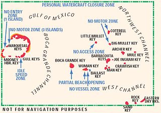
The Mule Keys are a group of scattered islets in the Florida Keys in Monroe County, Florida, United States. They are between 3 and 12 mi west of Key West, separated from it by the Northwest Channel. On the west, they are separated from the Marquesas Keys by the 6-mile (9.7 km) wide Boca Grande Channel. They belong to the outlying islands of the Florida Keys. Administratively, they are an unincorporated area of Monroe County. The islets are part of the Key West National Wildlife Refuge. The area of the islets totals 1.07 sq mi (2.8 km2), of which 1.02 sq mi (2.6 km2) are land area and 0.05 sq mi (0.13 km2) inland water bodies. The islets are uninhabited except for Mule Key, for which the census of 2000 lists one housing unit with a population of two.

Prvić is an uninhabited island in the Croatian part of the Adriatic Sea, located in the Kvarner Gulf. It is the largest of the so-called Senj Islands, a group of small islands and islets located off the coast of the mainland city of Senj, lying between the larger islands of Krk and Rab. Other significant islands in the Senj group are Sveti Grgur and Goli Otok, along with a number of islets and rocks, which are all uninhabited. Prvić has an area is 12.76 square kilometres (4.93 sq mi), which makes it the largest uninhabited Croatian island and 30th largest overall.

Falkonera or Gerakoulia (Γερακούλια), anciently known as Hierakia (Ἱεράκια), is a small uninhabited Greek island in the southwestern Aegean Sea, between the island of Milos and the Peloponnese. Although outside the Saronic Gulf, it is generally included among the Saronic Islands. The islet marks the summit of a horst tending WNW-ESE, which separates the Myrtoon basin to the north from the Cretan basin to the south.

Nimos is an uninhabited Greek island in the Dodecanese island group of the southern Aegean Sea. Located off the northern coast of Symi, from which it is separated by a small shallow strait called Diapori, it has an area of 4.6 square kilometres (1.8 sq mi). It is the island Ymos of the ancient Greeks.

Bahía de Loreto National Park is a national park on the east coast of the Baja California Peninsula in Mexico, about 203 kilometres (126 mi) north of the city of La Paz in the state of Baja California Sur. The park protects 2,065.81 square kilometres (797.61 sq mi) of relatively pristine marine ecosystem in the central Sea of Cortez, including five large uninhabited islands and many smaller islets in Loreto Bay. It is known for its great variety of coastal environments, such as sandy beaches, sea cliffs, submarine canyons, and marine terraces, and is home to an exceptionally high biological diversity, especially of marine mammals.


