
The Aegean Sea is an elongated embayment of the Mediterranean Sea located between the Greek and Anatolian peninsulas i.e. between the mainlands of Greece and Turkey. In the north, the Aegean is connected to the Marmara Sea and Black Sea by the Dardanelles and Bosphorus. The Aegean Islands are within the sea and some bound it on its southern periphery, including Crete and Rhodes.

An archipelago, sometimes called an island group or island chain, is a chain, cluster or collection of islands, or sometimes a sea containing a small number of scattered islands.
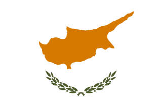
Cyprus, officially the Republic of Cyprus, is an island country in the Eastern Mediterranean and the third largest and third most populous island in the Mediterranean, located south of Turkey, west of Syria and Lebanon, northwest of Israel, north of Egypt, and southeast of Greece.

Crete is the largest and most populous of the Greek islands, the 88th largest island in the world and the fifth largest island in the Mediterranean Sea, after Sicily, Sardinia, Cyprus, and Corsica. Crete and a number of surrounding islands and islets constitute the region of Crete, one of the 13 top-level administrative units of Greece. The capital and the largest city is Heraklion. As of 2011, the region had a population of 623,065.

Chios is the fifth largest of the Greek islands, situated in the Aegean Sea, 7 kilometres (4.3 mi) off the Anatolian coast. The island is separated from Turkey by the Chios Strait. Chios is notable for its exports of mastic gum and its nickname is the Mastic Island. Tourist attractions include its medieval villages and the 11th-century monastery of Nea Moni, a UNESCO World Heritage Site.

Santorini, officially Thira and classic Greek Thera, is an island in the southern Aegean Sea, about 200 km (120 mi) southeast of Greece's mainland. It is the largest island of a small, circular archipelago, which bears the same name and is the remnant of a volcanic caldera. It forms the southernmost member of the Cyclades group of islands, with an area of approximately 73 km2 (28 sq mi) and a 2011 census population of 15,550. The municipality of Santorini includes the inhabited islands of Santorini and Therasia and the uninhabited islands of Nea Kameni, Palaia Kameni, Aspronisi, and Christiana. The total land area is 90.623 km2 (34.990 sq mi). Santorini is part of the Thira regional unit.
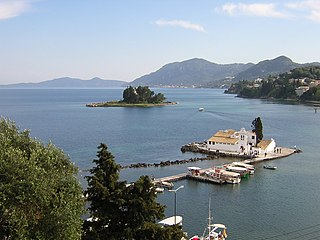
Corfu or Kerkyra is a Greek island in the Ionian Sea. It is the second largest of the Ionian Islands, and, including its small satellite islands, forms the northwesternmost part of Greece. The island is part of the Corfu regional unit, and is administered as a single municipality, which also includes the smaller islands of Ereikoussa, Mathraki and Othonoi. The municipality has an area of 610,9 km2, the island proper 592,8 km2. The principal city of the island and seat of the municipality is also named Corfu. Corfu is home to the Ionian University.

Naxos is a Greek island and the largest of the Cyclades. It was the centre of archaic Cycladic culture. The island is famous as a source of emery, a rock rich in corundum, which until modern time was one of the best abrasives available.

Euboea or Evia; Greek: Εύβοια, Evvoia, pronounced [ˈevia]; Ancient Greek: Εὔβοια, Eúboia, [eúboja]) is the second-largest Greek island in area and population, after Crete. The narrow Euripus Strait separates it from Boeotia in mainland Greece. In general outline it is a long and narrow island; it is about 180 kilometres (110 mi) long, and varies in breadth from 50 kilometres (31 mi) to 6 kilometres (3.7 mi). Its geographic orientation is from northwest to southeast, and it is traversed throughout its length by a mountain range, which forms part of the chain that bounds Thessaly on the east, and is continued south of Euboea in the lofty islands of Andros, Tinos and Mykonos.

Salamis, is the largest Greek island in the Saronic Gulf, about 1 nautical mile (2 km) off-coast from Piraeus and about 16 kilometres west of central Athens. The chief city, Salamina, lies in the west-facing core of the crescent on Salamis Bay, which opens into the Saronic Gulf. On the Eastern side of the island is its main port, Paloukia, in size second in Greece only to Piraeus, the port of Athens.
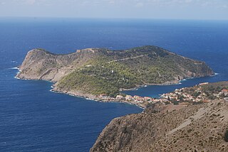
Cephalonia or Kefalonia, formerly also known as Kefallinia or Kephallenia (Κεφαλληνία), is the largest of the Ionian Islands in western Greece and the 6th largest island in Greece after Crete, Evoia, Lesbos, Rhodes, and Chios. It is also a separate regional unit of the Ionian Islands region, and the only municipality of the regional unit. It was also a former Latin Catholic diocese Kefalonia–Zakynthos (Cefalonia–Zante) and short-lived titular see as just Kefalonia.

The Ionian Islands are a group of islands in Greece. They are traditionally called the Heptanese, i.e. "the Seven Islands", but the group includes many smaller islands as well as the seven principal ones.
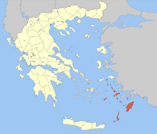
The Dodecanese are a group of 15 larger plus 150 smaller Greek islands in the southeastern Aegean Sea, off the coast of Asia Minor (Turkey), of which 26 are inhabited. Τhis island group generally defines the eastern limit of the Sea of Crete. They belong to the wider Southern Sporades island group.

Zakynthos or Zante, is a Greek island in the Ionian Sea. It is the third largest of the Ionian Islands. Zakynthos is a separate regional unit of the Ionian Islands region, and its only municipality. It covers an area of 405.55 km2 (156.6 sq mi) and its coastline is roughly 123 km (76 mi) in length. The name, like all similar names ending in -nthos, is pre-Mycenaean or Pelasgian in origin. In Greek mythology the island was said to be named after Zakynthos, the son of the legendary Arcadian chief Dardanus.

The Aegean Islands are the group of islands in the Aegean Sea, with mainland Greece to the west and north and Turkey to the east; the island of Crete delimits the sea to the south, those of Rhodes, Karpathos and Kasos to the southeast. The ancient Greek name of the Aegean Sea, Archipelago was later applied to the islands it contains and is now used more generally, to refer to any island group.

Lesbos is an island located in the northeastern Aegean Sea. It has an area of 1,633 km2 (631 sq mi) with 320 kilometres of coastline, making it the third largest island in Greece. It is separated from Turkey by the narrow Mytilini Strait and in late Palaeolithic/Mesolithic times was joined to the Anatolian mainland before the end of the last glacial period.

Greece is a country in Southern Europe, bordered to the north by Albania, North Macedonia and Bulgaria; to the east by Turkey, and is surrounded to the east by the Aegean Sea, to the south by the Cretan and the Libyan Seas, and to the west by the Ionian Sea which separates Greece from Italy.

Rhodes is the largest of the Dodecanese islands of Greece and is also the island group's historical capital. Administratively the island forms a separate municipality within the Rhodes regional unit, which is part of the South Aegean administrative region. The principal town of the island and seat of the municipality is Rhodes. The city of Rhodes had 50,636 inhabitants in 2011. It is located northeast of Crete, southeast of Athens and just off the Anatolian coast of Turkey. Rhodes' nickname is The island of the Knights, named after the Knights of Saint John of Jerusalem, who once conquered the land.


