The Aegean Sea is an elongated embayment of the Mediterranean Sea located between the Greek and Anatolian peninsulas i.e. between the mainlands of Greece and Turkey. In the north, the Aegean is connected to the Marmara Sea and Black Sea by the Dardanelles and Bosphorus. The Aegean Islands are within the sea and some bound it on its southern periphery, including Crete and Rhodes.

Chania is the second largest city of Crete and the capital of the Chania regional unit. It lies along the north coast of the island, about 70 km (43 mi) west of Rethymno and 145 km (90 mi) west of Heraklion.

Karpathos, also Carpathos, is the second largest of the Greek Dodecanese islands, in the southeastern Aegean Sea. Together with the neighboring smaller Saria Island it forms the municipality of Karpathos, which is part of the Karpathos regional unit. Because of its remote location, Karpathos has preserved many peculiarities of dress, customs and dialect, the last resembling those of Crete and Cyprus. The island has also been called Carpathus in Latin, Scarpanto in Italian.

Sitia is a port town and a municipality in Lasithi, Crete, Greece. The town has 9,912 inhabitants (2011) and the municipality has 18,318 (2011). It lies east of Agios Nikolaos and northeast of Ierapetra. Sitia port is on the Sea of Crete, part of the Aegean Sea and is one of the economic centers of the Lasithi region. European route E75, which ends in Vardø, starts in Sitia. Sitia is served by the Sitia Public Airport. Sitia has not experienced the effects of mass tourism even though there is a long beach along the road leading to Vai and several places of historical interest.
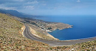
Hóra Sfakíon or Sfakia is a town on the south coast of Crete, Greece. It is the capital of the remote and mountainous region of Sfakiá, and is a small town of just 265 inhabitants. It lies on the south coast near the end of the Imbros Gorge, 74 km south of Chania. It has two small harbours, where the ferry boats from Agia Roumeli dock, which in the summer bring the hikers from the Samaria Gorge to take buses back to the northern coast. From Hóra Sfakíon ferries also go to the nearby coastal town of Loutro and the island Gavdos.
Souda is a town and former municipality in the Chania regional unit, Crete, Greece. Since the 2011 local government reform it is part of the municipality Chania, of which it is a municipal unit. The municipal unit has an area of 22.007 km2 (8.497 sq mi). It is an important ferry and naval port at the head of Souda Bay.

Chania is one of the four regional units of Crete; it covers the westernmost quarter of the island. Its capital is the city of Chania. Chania borders only one other regional unit: that of Rethymno to the east. The western part of Crete is bounded to the north by the Cretan Sea, and to the west and south by the Mediterranean Sea. The regional unit also includes the southernmost island of Europe, Gavdos.

The island of Spinalonga is located in the Gulf of Elounda in north-eastern Crete, in Lasithi, next to the town of Plaka. The island is further assigned to the area of Kalydon. It is near the Spinalonga peninsula – which often causes confusion as the same name is used for both. The official Greek name of the island today is Kalydon.

Souda Bay is a bay and natural harbour near the town of Souda on the northwest coast of the Greek island of Crete. The bay is about 15 km long and only two to four km wide, and a deep natural harbour. It is formed between the Akrotiri peninsula and Cape Drapano, and runs west to east. The bay is overlooked on both sides by hills, with a relatively low and narrow isthmus in the west near Chania.

The term Drosoulites refers to a long procession of visions, seen by residents around Frangokastello castle in Sfakia region of Crete (Greece). The phenomenon is rumored to be visible every year, on the anniversary of the Battle of Frangokastello or even in early June near a small village in southern Crete.

The Nautical Museum of Crete is a museum in Chania, Crete, Greece. Its collection includes models of ships, nautical instruments, painting, historical photographs and war relics. The material is classified chronologically, starting from the Bronze Age up to our times.

Emmanouil Tombazis was a Greek naval captain from Hydra, active during the Greek War of Independence, who was appointed Commissioner of Crete for the Greek provisional government in 1823–1824 and naval minister for a short period in 1828.

Gramvousa also Grampousa refers to two small uninhabited islands off the coast of a peninsula also known Gramvousa Peninsula in north-western Crete in the regional unit of Chania. The Gramvousa Peninsula forms the westernmost of the two pairs of peninsulae in north-western Crete and is the western part of Kissamos Bay.

Hatzimichalis Dalianis was a commander of the Greek War of Independence (1821–1830) and revolutionary leader in Crete in 1828.
Kaloi Limenes or Kali Limenes is a village and port in the Heraklion regional unit, southern Crete, in Greece, located 82 kilometres (51 mi) south-west of the city of Heraklion. It has 21 inhabitants (2011). It is known as a major bunkering spot for ships in the southern Mediterranean.
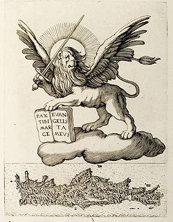
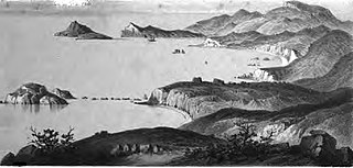
The Realm or Kingdom of Candia or Duchy of Candia was the official name of Crete during the island's period as an overseas colony of the Republic of Venice, from the initial Venetian conquest in 1205–1212 to its fall to the Ottoman Empire during the Cretan War (1645–1669). The island was at the time and up to the early modern era commonly known as Candia after its capital, Candia or Chandax. In modern Greek historiography, the period is known as the Venetocracy.