Geography of Slovakia

Last updated

A topographical map of Slovakia Slovakia topo.jpg
A topographical map of Slovakia
Map of Slovakia with the main mountain ranges Slovakia general relief map.svg
Map of Slovakia with the main mountain ranges

Slovakia is a landlocked Central European country with mountainous regions in the north and flat terrain in the south. [1] During much of the Holocene, Slovakia was much more forested than today. [1] Decline of the forest occurred in as consequence of the Valachian colonization and the development of mining in the territory. [1]

Contents

Statistics

Land use:

agricultural land: 40.1%

arable land: 28.9%; permanent crops: 0.4%; permanent pasture: 10.8%

forest: 40.2%

other: 19.7% (2011 est.)

Natural resources:

Lignite, small amounts of iron ore, copper and manganese ore; salt; arable land

Natural Hazards:

Flooding

Environment-international agreements:

Party to: Air Pollution, Air Pollution-Nitrogen Oxides, Air Pollution-Persistent Organic Pollutants, Air Pollution-Sulfur 85, Air Pollution-Sulfur 94, Air Pollution-Volatile Organic Compounds, Antarctic Treaty, Biodiversity, Climate Change, Climate Change-Kyoto Protocol, Desertification, Endangered Species, Environmental Modification, Hazardous Wastes, Law of the Sea, Ozone Layer Protection, Ship Pollution, Wetlands, Whaling.

Signed, but not ratified: none of the selected agreements

Area

Slovakia's cities and main towns SlovakiaOMCmap.png
Slovakia's cities and main towns

Slovakia lies between 49°36'48" and 47°44'21" northern latitude and 16°50'56" and 22°33'53" eastern longitude.

The northernmost point is near Beskydok, a mountain on the border with Poland near the village of Oravská Polhora in the Beskids. The southernmost point is near the village of Patince on the Danube on the border with Hungary. The westernmost point is on the Morava River near Záhorská Ves on the Austrian border. The easternmost point is close to the summit of Kremenec, a mountain near the village of Nová Sedlica at the meeting point of Slovak, Polish, and Ukrainian borders.

Natural resources of Slovakia. Mg -- magneisum, Mn -- manganese, Fe -- iron ore, Cu -- copper, Sb -- antimony; PM -- polymetals (Pb, Zn and similar metals); L -- lignite, O -- oil. Natural resources of Slovakia.png
Natural resources of Slovakia. Mg — magneisum, Mn — manganese, Fe — iron ore, Cu — copper, Sb — antimony; PM — polymetals (Pb, Zn and similar metals); L — lignite, O — oil.
The highest mountain Gerlach south face B.jpg
The highest mountain

The highest point is at the summit of Gerlachovský štít in the High Tatras, 2,655 m (8,710.6 ft), the lowest point is the surface of the Bodrog River on the Hungarian border at 94 m (308.4 ft).

The country's area is 48,845 km2 (18,859 sq mi). 31% is arable land, 17% pastures, 41% forests, 3% cultivated land. The remaining 8% is mostly covered with human structures and infrastructure, and partly with rocky mountain ridges and other unimproved land. [2]

Slovakia borders Poland in the north - 547 km (339.9 mi), Ukraine in the east - 98 km (60.9 mi), Hungary in the south - 679 km (421.9 mi), Austria in the south-west - 106 km (65.9 mi), and the Czech Republic in the north-west - 252 km (156.6 mi) for a total border length of 1,672 km (1,038.9 mi). [3]

The village of Veľké Slemence (Ukrainian: Mali Slementsi/Малі Селменці, Hungarian: Szelmenc) is an anomaly, as it is a village with a majority of Hungarians, but it is split between Slovakia and Ukraine. [4]

National parks

Slovak Paradise National Park Palcmanska Masa.JPG
Slovak Paradise National Park

There are 9 national parks in Slovakia, covering 6.5% of the Slovak land surface. [5]

NameEstablishedArea (km2)
Tatra National Park 1949738
Low Tatras National Park 1978728
Veľká Fatra National Park 2002404
Slovak Karst National Park 2002346
Poloniny National Park 1997298
Malá Fatra National Park 1988226
Muránska planina National Park 1998203
Slovak Paradise National Park 1988197
Pieniny National Park 196738

Geographical features

Tatra mountains

A topographical map of Slovakia Slovakia topo.jpg
A topographical map of Slovakia

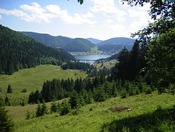
The Tatra Mountains, with 29 peaks higher than 2,500 metres (8,202 feet) AMSL, are the highest mountain range in the Carpathian Mountains. The Tatras occupy an area of 750 square kilometres (290 sq mi), of which the greater part 600 square kilometres (232 sq mi) lies in Slovakia. They are divided into several parts.

To the north, close to the Polish border, are the High Tatras which are a popular hiking and skiing destination and home to many scenic lakes and valleys as well as the highest point in Slovakia, the Gerlachovský štít at 2,655 metres (8,711 ft) and the country's highly symbolic mountain Kriváň. To the west are the Western Tatras with their highest peak of Bystrá at 2,248 metres (7,375 ft) and to the east are the Belianske Tatras, smallest by area.

Separated from the Tatras proper by the valley of the Váh river are the Low Tatras, with their highest peak of Ďumbier at 2,043 metres (6,703 ft).

The Tatra mountain range is represented as one of the three hills on the coat of arms of Slovakia.

Caves

Domica Cave Domica Cave 20.jpg
Domica Cave

Slovakia has hundreds of caves and caverns under its mountains, of which 30 are open to the public. [6] Most of the caves have stalagmites rising from the ground and stalactites hanging from above. There are currently five Slovak caves under UNESCO's World Heritage Site status. They are Dobšiná Ice Cave, Domica, Gombasek Cave, Jasovská Cave and Ochtinská Aragonite Cave. Other caves open to the public include Belianska Cave, Demänovská Cave of Liberty, Demänovská Ice Cave or Bystrianska Cave.

Rivers

Bela River Bela river (Slovakia).jpg
Belá River

Most of the rivers arise in the Slovak mountains. Some only pass through Slovakia, while others make a natural border with surrounding countries (more than 620 kilometres [390 mi]). For example, the Dunajec (17 kilometres [11 mi]) to the north, the Danube (172 kilometres [107 mi]) to the south or the Morava (119 kilometres [74 mi]) to the West. The total length of the rivers on Slovak territory is 49,774 kilometres (30,928 mi).

The longest river in Slovakia is the Váh (403 kilometres [250 mi]), the shortest is the Čierna voda. Other important and large rivers are the Myjava, the Nitra (197 kilometres [122 mi]), the Orava, the Hron (298 kilometres [185 mi]), the Hornád (193 kilometres [120 mi]), the Slaná (110 kilometres [68 mi]), the Ipeľ (232 kilometres [144 mi], forming the border with Hungary), the Bodrog, the Laborec, the Latorica and the Ondava.

The biggest volume of discharge in Slovak rivers is during spring, when the snow melts from the mountains. The only exception is the Danube, whose discharge is the greatest during summer when the snow melts in the Alps. The Danube is the largest river that flows through Slovakia. [7]

Climate

The Slovak climate lies between the temperate and continental climate zones with relatively warm summers and cold, cloudy and humid winters. Temperature extremes are between −41 and 40.3 °C (−41.8 and 104.5 °F) although temperatures below −30 °C (−22 °F) are rare. The weather differs from the mountainous north to the plains in the south.

The warmest region is Bratislava and Southern Slovakia where the temperatures may reach 30 °C (86 °F) in summer, occasionally to 39 °C (102 °F) in Hurbanovo. During night, the temperatures drop to 20 °C (68 °F). The daily temperatures in winter average in the range of −5 °C (23 °F) to 10 °C (50 °F). During night it may be freezing, but usually not below −10 °C (14 °F).

In Slovakia, there are four seasons, each season (spring, summer, autumn and winter) lasts three months. The dry continental air brings in the summer heat and winter frosts. In contrast, oceanic air brings rainfalls and reduces summer temperatures. In the lowlands and valleys, there is often fog, especially in winter.

Spring starts with 21 March and is characterised by colder weather with an average daily temperature of 9 °C (48 °F) in the first weeks and about 14 °C (57 °F) in May and 17 °C (63 °F) in June. In Slovakia, the weather and climate in the spring are very unstable.

Summer starts on 22 June and is usually characterised by hot weather with daily temperatures exceeding 30 °C (86 °F). July and August are the warmest months with temperatures up to about 37 to 40 °C (99 to 104 °F), especially in regions of southern Slovakia - in the urban area of Komárno, Hurbanovo or Štúrovo. Showers or thunderstorms may occur because of the summer monsoon called Medardova kvapka (Medard drop - 40 days of rain). Summer in Northern Slovakia is usually mild with temperatures around 25 °C (77 °F) (less in the mountains).

Autumn in Slovakia starts on 23 September and is mostly characterised by wet weather and wind, although the first weeks can be very warm and sunny. The average temperature in September is around 14 °C (57 °F), in November to 3 °C (37 °F). Late September and early October is a dry and sunny time of year (so-called Indian summer).

Winter starts on 21 December with temperatures around −5 to −10 °C (23 to 14 °F). In December and January, it is usually snowing, these are the coldest months of the year. At lower altitudes, snow does not stay the whole winter, it changes into the thaw and frost. Winters are colder in the mountains, where the snow usually lasts until March or April and the night temperatures fall to −20 °C (−4 °F) and colder. [8]

Examples

Climate data for Bratislava (1981–2010)
MonthJanFebMarAprMayJunJulAugSepOctNovDecYear
Record high °C (°F)19.8
(67.6)
19.1
(66.4)
25.0
(77.0)
30.3
(86.5)
33.4
(92.1)
36.3
(97.3)
38.2
(100.8)
39.3
(102.7)
34.0
(93.2)
30.0
(86.0)
21.3
(70.3)
17.9
(64.2)
39.3
(102.7)
Mean daily maximum °C (°F)2.7
(36.9)
5.1
(41.2)
10.3
(50.5)
16.7
(62.1)
21.8
(71.2)
24.9
(76.8)
27.5
(81.5)
27.0
(80.6)
21.7
(71.1)
15.6
(60.1)
8.2
(46.8)
3.3
(37.9)
15.4
(59.7)
Daily mean °C (°F)−0.4
(31.3)
1.2
(34.2)
5.5
(41.9)
11.0
(51.8)
16.0
(60.8)
19.1
(66.4)
21.3
(70.3)
20.7
(69.3)
15.9
(60.6)
10.4
(50.7)
4.9
(40.8)
0.7
(33.3)
10.5
(50.9)
Mean daily minimum °C (°F)−3.4
(25.9)
−2.3
(27.9)
1.3
(34.3)
5.4
(41.7)
10.2
(50.4)
13.4
(56.1)
15.4
(59.7)
15.0
(59.0)
11.0
(51.8)
6.1
(43.0)
1.8
(35.2)
−1.9
(28.6)
6.0
(42.8)
Record low °C (°F)−24.6
(−12.3)
−20
(−4)
−15.1
(4.8)
−4.4
(24.1)
−2
(28)
3.0
(37.4)
7.0
(44.6)
5.0
(41.0)
−2.0
(28.4)
−8
(18)
−12
(10)
−20
(−4)
−24.6
(−12.3)
Average precipitation mm (inches)39
(1.5)
37
(1.5)
38
(1.5)
34
(1.3)
55
(2.2)
57
(2.2)
53
(2.1)
59
(2.3)
55
(2.2)
38
(1.5)
54
(2.1)
46
(1.8)
565
(22.2)
Average snowfall cm (inches)10.7
(4.2)
5.7
(2.2)
1.6
(0.6)
0.2
(0.1)
0.0
(0.0)
0.0
(0.0)
0.0
(0.0)
0.0
(0.0)
0.0
(0.0)
0.2
(0.1)
1.8
(0.7)
4.0
(1.6)
24.2
(9.5)
Average relative humidity (%)83787164676664657378838573
Mean monthly sunshine hours 65.181.9151.9204.0263.5270.0275.9269.7207.0142.660.046.52,038.1
Average ultraviolet index 1234677643114
Source: Pogodaiklimat.ru, [9] Climatemps [10] and Weather Atlas [11]
Climate data for Košice, Slovakia (1991−2020 normals, extremes 1980−present)
MonthJanFebMarAprMayJunJulAugSepOctNovDecYear
Record high °C (°F)13.1
(55.6)
16.5
(61.7)
23.2
(73.8)
28.7
(83.7)
31.7
(89.1)
34.6
(94.3)
38.0
(100.4)
36.1
(97.0)
34.1
(93.4)
26.6
(79.9)
22.4
(72.3)
13.3
(55.9)
38.0
(100.4)
Mean daily maximum °C (°F)1.0
(33.8)
3.7
(38.7)
9.9
(49.8)
16.5
(61.7)
21.2
(70.2)
24.8
(76.6)
26.6
(79.9)
26.8
(80.2)
21.2
(70.2)
14.8
(58.6)
8.1
(46.6)
1.8
(35.2)
14.7
(58.5)
Daily mean °C (°F)−2.6
(27.3)
−0.4
(31.3)
4.5
(40.1)
9.6
(49.3)
14.6
(58.3)
17.5
(63.5)
19.3
(66.7)
19.1
(66.4)
14.8
(58.6)
9.4
(48.9)
3.0
(37.4)
−1.3
(29.7)
9.0
(48.1)
Mean daily minimum °C (°F)−4.8
(23.4)
−3.5
(25.7)
0.0
(32.0)
5.0
(41.0)
9.6
(49.3)
13.2
(55.8)
14.8
(58.6)
14.6
(58.3)
10.1
(50.2)
5.3
(41.5)
1.2
(34.2)
−3.3
(26.1)
5.2
(41.3)
Record low °C (°F)−25.9
(−14.6)
−22.3
(−8.1)
−16.4
(2.5)
−7.2
(19.0)
−2.0
(28.4)
2.9
(37.2)
5.6
(42.1)
1.2
(34.2)
0.3
(32.5)
−7.5
(18.5)
−13.5
(7.7)
−19.2
(−2.6)
−25.9
(−14.6)
Average precipitation mm (inches)25.7
(1.01)
26.8
(1.06)
23.6
(0.93)
42.4
(1.67)
69.4
(2.73)
87.5
(3.44)
93.5
(3.68)
66.5
(2.62)
50.1
(1.97)
51.1
(2.01)
40.2
(1.58)
36.1
(1.42)
612.9
(24.12)
Average precipitation days12.710.89.010.813.313.412.99.710.711.011.914.2140.4
Average relative humidity (%)78725951515553535361768262
Mean monthly sunshine hours 678616620426625928225821615368472,072
Source 1: World Meteorological Organisation [12]
Source 2: Danish Meteorological Institute (humidity and sun 1931–1960) [13] [14]
Climate data for Hurbanovo
MonthJanFebMarAprMayJunJulAugSepOctNovDecYear
Record high °C (°F)13.4
(56.1)
20.8
(69.4)
25.7
(78.3)
30.0
(86.0)
33.4
(92.1)
34.8
(94.6)
40.3
(104.5)
38.0
(100.4)
33.4
(92.1)
27.6
(81.7)
23.2
(73.8)
19.0
(66.2)
40.3
(104.5)
Mean daily maximum °C (°F)1.6
(34.9)
4.8
(40.6)
10.6
(51.1)
16.6
(61.9)
21.7
(71.1)
24.7
(76.5)
26.8
(80.2)
26.2
(79.2)
22.3
(72.1)
16.3
(61.3)
8.4
(47.1)
3.2
(37.8)
15.3
(59.5)
Daily mean °C (°F)−1.5
(29.3)
1.0
(33.8)
5.4
(41.7)
10.7
(51.3)
15.6
(60.1)
18.7
(65.7)
20.2
(68.4)
19.5
(67.1)
15.5
(59.9)
10.2
(50.4)
4.7
(40.5)
0.4
(32.7)
10.0
(50.0)
Mean daily minimum °C (°F)−4.7
(23.5)
−2.5
(27.5)
0.9
(33.6)
5.0
(41.0)
9.6
(49.3)
12.7
(54.9)
13.8
(56.8)
13.5
(56.3)
10.1
(50.2)
5.4
(41.7)
1.4
(34.5)
−2.5
(27.5)
5.2
(41.4)
Record low °C (°F)−23.0
(−9.4)
−22.4
(−8.3)
−21.4
(−6.5)
−5.3
(22.5)
−1.8
(28.8)
2.2
(36.0)
4.5
(40.1)
4.5
(40.1)
−1.7
(28.9)
−1.6
(29.1)
−14.1
(6.6)
−21.0
(−5.8)
−23.0
(−9.4)
Average precipitation mm (inches)33.9
(1.33)
34.0
(1.34)
26.6
(1.05)
38.8
(1.53)
55.3
(2.18)
60.8
(2.39)
50.7
(2.00)
37.0
(1.46)
38.9
(1.53)
32.2
(1.27)
53.7
(2.11)
39.8
(1.57)
521.7
(20.54)
Average precipitation days (≥ 1.0 mm)6.96.45.96.48.38.37.16.85.65.07.87.582.0
Average relative humidity (%)83797265666866697476828574
Mean monthly sunshine hours 61.985.0134.3178.8229.0237.4259.4236.8184.3143.769.151.61,871.3
Source: NOAA [15] OGIMET [16]

Biodiversity

Rupicapra rupicapra tatrica in the Tatra Mountains Vysoke Tatry, Dolina Bielej vody, cestou od Zeleneho plesa na Jahnaci stit (32).JPG
Rupicapra rupicapra tatrica in the Tatra Mountains

Slovakia signed the Rio Convention on Biological Diversity on 19 May 1993, and became a party to the convention on 25 August 1994. [17] It has subsequently produced a National Biodiversity Strategy and Action Plan, which was received by the convention on 2 November 1998. [18]

The biodiversity of Slovakia comprises animals (such as annelids, arthropods, molluscs, nematodes and vertebrates), fungi (Ascomycota, Basidiomycota, Chytridiomycota, Glomeromycota and Zygomycota), micro-organisms (including Mycetozoa), and plants. The geographical position of Slovakia determines the richness of the diversity of fauna and flora. More than 11,000 plant species have been described throughout its territory, nearly 29,000 animal species and over 1,000 species of protozoa. Endemic biodiversity is also common. [19]

Slovakia is located in the biome of temperate broadleaf and mixed forests and terrestrial ecoregions of Pannonian mixed forests and Carpathian montane conifer forests. [20] As the altitude changes, the vegetation associations and animal communities are forming height levels (oak, beech, spruce, scrub pine, alpine meadows and subsoil). Forests cover 44% of the territory of Slovakia. [21] The country had a 2019 Forest Landscape Integrity Index mean score of 4.34/10, ranking it 129th globally out of 172 countries. [22] In terms of forest stands, 60% are broadleaf trees and 40% are coniferous trees. The occurrence of animal species is strongly connected to the appropriate types of plant associations and biotopes. [19]

Over 4,000 species of fungi have been recorded from Slovakia. [23] [24] Of these, nearly 1,500 are lichen-forming species. [25] Some of these fungi are undoubtedly endemic, but not enough is known to say how many. Of the lichen-forming species, about 40% have been classified as threatened in some way. About 7% are apparently extinct, 9% endangered, 17% vulnerable, and 7% rare. The conservation status of non-lichen-forming fungi in Slovakia is not well documented, but there is a red list for its larger fungi. [26]

Lakes

Related Research Articles

<span class="mw-page-title-main">Geography of Albania</span>

Albania is a country in Southeastern Europe that lies along the Adriatic and Ionian Seas, with a coastline spanning approximately 476 km (296 mi). Situated on the Balkan Peninsula, it is one of the most mountainous countries in Europe. It is bounded by Montenegro to the northwest, Kosovo to the northeast, North Macedonia to the east and Greece to the southeast and south.

<span class="mw-page-title-main">Geography of Hungary</span>

Hungary is a landlocked country in the southeastern region of Central Europe, bordering the Balkans. Situated in the Pannonian Basin, it has a land area of 93,030 square km, measuring about 250 km from north to south and 524 km from east to west. It has 2,106 km of boundaries, shared with Slovakia to the north, Ukraine to the northeast, Romania to the east and southeast, Serbia to the south, Croatia to the southwest, Slovenia to the west and southwest, and Austria to the west.

<span class="mw-page-title-main">Geography of Kenya</span> Geographical features of Kenya

The Geography of Kenya is diverse, varying amongst its 47 counties. Kenya has a coastline on the Indian Ocean, which contains swamps of East African mangroves. Inland are broad plains and numerous hills. Kenya borders South Sudan to the northwest, Uganda to the west, Somalia to the east, Tanzania to the south, and Ethiopia to the north. Kenya currently faces border disputes with South Sudan over the Ilemi Triangle and with Somalia over Jubbaland where, if the Somalian Government gives it up, it could be a new part of Kenya, which would bring the total land area of Kenya to approximately 692,939 km2.

<span class="mw-page-title-main">Geography of Lithuania</span>

Lithuania is a country in the Baltic region of Europe. The most populous of the Baltic states, Lithuania has 262 km (163 mi) of coastline consisting of the continental coast and the "Curonian Spit" coast. Lithuania's major warm-water port of Klaipėda lies at the narrow mouth of Curonian Lagoon, a shallow lagoon extending south to Kaliningrad and separated from the Baltic sea by Curonian Spit, where Kuršių Nerija National Park was established for its remarkable sand dunes.

<span class="mw-page-title-main">Geography of Morocco</span> Overview of the geography of Morocco

Morocco is the northwesternmost country which spans from the Mediterranean Sea and Atlantic Ocean on the north and the west respectively, into large mountainous areas in the interior, to the Sahara desert in the far south. Morocco is a Northern African country, located in the extreme northwest of Africa on the edge of continental Europe. The Strait of Gibraltar separates Spain from Morocco with a 13 kilometres (8.1 mi) span of water. Morocco borders the North Atlantic Ocean to the west, and the western Mediterranean Sea to the north, and has borders with Algeria and disputed Western Sahara.

<span class="mw-page-title-main">Geography of Romania</span> Overview of the geography of Romania

With an area of 238,397 km2 (92,046 sq mi), Romania is the twelfth-largest country in Europe. It is a Balkan country located at the crossroads of Eastern and Southeast Europe. It's bordered on the Black Sea, the country is halfway between the equator and the North Pole and equidistant from the westernmost part of Europe—the Atlantic Coast—and the most easterly—the Ural Mountains. Romania has 3,195 kilometres (1,985 mi) of border. Republic of Moldova and Ukraine lies to the east, Bulgaria lies to the south, and Serbia and Hungary to the west by the Pannonian Plain. In the southeast, 245 kilometres (152 mi) of sea coastline provide an important outlet to the Black Sea and the Atlantic Ocean.

<span class="mw-page-title-main">Slovakia</span> Country in Central Europe

Slovakia, officially the Slovak Republic, is a landlocked country in Central Europe. It is bordered by Poland to the north, Ukraine to the east, Hungary to the south, Austria to the west, and the Czech Republic to the northwest. Slovakia's mostly mountainous territory spans about 49,000 square kilometres (19,000 sq mi), hosting a population exceeding 5.4 million. The capital and largest city is Bratislava, while the second largest city is Košice.

<span class="mw-page-title-main">Geography of Eswatini</span>

Eswatini, is a country in Southern Africa lying between Mozambique and South Africa. The country is located at the geographic coordinates 26°30′S31°30′E. Eswatini has an area of 17,363 square kilometres, of which 160 are water. The major regions of the country are Lowveld, Midveld and Highveld.

<span class="mw-page-title-main">Geography of Portugal</span> Geographical features of Portugal

Portugal is a coastal nation in western Europe, located at the western end of the Iberian Peninsula, bordering Spain. The Portuguese territory also includes a series of archipelagos in the Atlantic Ocean, which are strategic islands along the North Atlantic. The extreme south is not too far from the Strait of Gibraltar, leading to the Mediterranean Sea. In total, the country occupies an area of 92,090 square kilometres (35,560 sq mi) of which 91,470 square kilometres (35,320 sq mi) is land and 620 square kilometres (240 sq mi) water.

<span class="mw-page-title-main">Geography of Norway</span>

Norway is a country located in Northern Europe in the northern and western parts of the Scandinavian Peninsula. The majority of the country borders water, including the Skagerrak inlet to the south, the North Sea to the southwest, the North Atlantic Ocean to the west, and the Barents Sea to the north. It has a land border with Sweden to the east; to the northeast it has a shorter border with Finland and an even shorter border with Russia.

<span class="mw-page-title-main">Tatra Mountains</span> Mountain range on the Polish–Slovak border

The Tatra Mountains, Tatras, or Tatra, are a series of mountains within the Western Carpathians that form a natural border between Slovakia and Poland. They are the highest mountains in the Carpathians. The Tatras are distinct from the Low Tatras, a separate Slovak mountain range further south.

<span class="mw-page-title-main">Piešťany</span> Town in Slovakia

Piešťany is a town in Slovakia. It is located in the western part of the country within the Trnava Region and is the seat of its own district. It is the biggest and best known spa town in Slovakia and has around 28,000 inhabitants.

<span class="mw-page-title-main">Liptovský Hrádok</span> Town in Slovakia

Liptovský Hrádok is a town in northern Slovakia, in the region of Liptov.

<span class="mw-page-title-main">High Tatras</span> Mountain range along the border of Slovakia and Poland

The High Tatras or High Tatra Mountains, are a mountain range along the border of northern Slovakia in the Prešov Region, and southern Poland in the Lesser Poland Voivodeship. They are a range of the Tatra Mountains chain.

<span class="mw-page-title-main">Tatra National Park, Poland</span>

Tatra National Park is a national park located in the Tatra Mountains in Tatra County, in the Lesser Poland Voivodeship in central-southern Poland. The park is headquartered in the town of Zakopane.

<span class="mw-page-title-main">Tourism in Slovakia</span>

Tourism in Slovakia offers natural landscapes, mountains, caves, medieval castles and towns, folk architecture, spas and ski resorts.

Veľké Lovce is a town and municipality in the Nové Zámky District in the Nitra Region of south-west Slovakia. Veľké Lovce is home to 2,079 people according to the 2004 census.

<span class="mw-page-title-main">Bratislava</span> Capital and largest city of Slovakia

Bratislava, historically known as Pressburg (Preßburg), is the capital and largest city of Slovakia and the fourth largest of all cities on Danube river. Officially, the population of the city is about 475,000; however, some sources estimate it to be more than 660,000—approximately 140% of the official figures. Bratislava is in southwestern Slovakia at the foot of the Little Carpathians, occupying both banks of the River Danube and the left bank of the River Morava. Bordering Austria and Hungary, it is the only national capital to border two sovereign states.

<span class="mw-page-title-main">Geography of Germany</span>

Germany is a country in Central and Western Europe that stretches from the Alps, across the North European Plain to the North Sea and the Baltic Sea. It is the second-most populous country in Europe after Russia, and is seventh-largest country by area in the continent. The area of Germany ranked 63rd and covers 357,021 km2 (137,847 sq mi), consisting of 349,223 km2 (134,836 sq mi) of land and 7,798 km2 (3,011 sq mi) of waters, smaller than Japan but larger than Republic of the Congo.

<span class="mw-page-title-main">Geography of Poland</span> Geographical features of Poland

Poland is a country that extends across the North European Plain from the Sudetes and Carpathian Mountains in the south to the sandy beaches of the Baltic Sea in the north. Poland is the fifth-most populous country of the European Union and the ninth-largest country in Europe by area. The territory of Poland covers approximately 312,696 km2 (120,733 sq mi), of which 98.52% is land and 1.48% is water. The Polish coastline was estimated at 770 km (478 mi) in length. Poland's highest point is Rysy, at 2,500 m (8,202 ft).

References

  1. 1 2 3 Vaškovský, Imrich; Vaškovská, Eugenia (1981). "The development of the natural landscape in Slovakia during the Quaternary". Biuletyn Peryglacjalny . 28: 249–258.
  2. "bedekr.cz".
  3. Slovak Wikipedia: sk:Slovensko#Hranice
  4. "Veľké Slemence". Veľké Slemence. Retrieved 2021-04-05.
  5. "Národné parky na Slovensku". lamnia.sk. Archived from the original on 10 October 2017. Retrieved 26 August 2017.
  6. "Verejnosti voľne prístupné jaskyne". ssj.sk. Retrieved 19 August 2017.
  7. Nie ste prihlásený. "Vodstvo – Jazerá - rieky - rybníky Slovenska". Slovakregion.sk. Retrieved 10 September 2013.
  8. "Based on the "Climate" article from". www.slovensko.com. Archived from the original on 26 October 2007. Retrieved 10 September 2013.
  9. "Pogodaiklimat.ru – Bratislava". Pogodaiklimat.ru. Retrieved 20 March 2014.
  10. "Climate of Bratislava". Climatemps. Archived from the original on May 6, 2019. Retrieved 20 March 2013.
  11. "Bratislava, Slovakia - Detailed climate information and monthly weather forecast". Weather Atlas. Yu Media Group. Retrieved 2019-07-03.
  12. "World Weather Information Service – Košice". July 2011.
  13. Cappelen, John; Jensen, Jens. "TJEKKIET - Kosice" (PDF). Climate Data for Selected Stations (1931-1960) (in Danish). Danish Meteorological Institute. p. 274. Archived from the original (PDF) on 27 April 2013. Retrieved 14 October 2019.
  14. "Normales et records pour la période 1991-2020 à Kosice". infoclimat.fr. Retrieved February 18, 2022.
  15. "Hurbanovo Climate Normals 1961-1990". National Oceanic and Atmospheric Administration . Retrieved March 3, 2015.
  16. "11858: Hurbanovo (Slovakia)". OGIMET. 26 February 2021. Retrieved 26 February 2021.
  17. "List of Parties". Archived from the original on 24 January 2011. Retrieved 8 December 2012.
  18. "National Biodiversity Strategy of Slovakia" (PDF). Archived from the original (PDF) on 21 July 2008. Retrieved 8 December 2012.
  19. 1 2 "Regionální geografie Slovenska - elektronická učebnice". geography.upol.cz. Retrieved 28 September 2019.
  20. Dinerstein, Eric; et al. (2017). "An Ecoregion-Based Approach to Protecting Half the Terrestrial Realm". BioScience. 67 (6): 534–545. doi: 10.1093/biosci/bix014 . ISSN   0006-3568. PMC   5451287 . PMID   28608869.
  21. "Tlačová agentúra Slovenskej republiky - TASR.sk". www.tasr.sk. Retrieved 28 September 2019.
  22. Grantham, H. S.; et al. (2020). "Anthropogenic modification of forests means only 40% of remaining forests have high ecosystem integrity - Supplementary Material". Nature Communications. 11 (1): 5978. doi: 10.1038/s41467-020-19493-3 . ISSN   2041-1723. PMC   7723057 . PMID   33293507.
  23. "Cybertruffle's Robigalia. Observations of fungi and their associated organisms" . Retrieved 8 December 2012.
  24. Pavel Lizoň & Kamila Bacigálová, Huby – Fungi in F. Hindák [ed.] Checklist of Non-vascular and Vascular Plants of Slovakia (Bratislava, 1998), pp. 102–227.
  25. Ivan Pišút, Lichenizované Huby (Lišajníky) – Lichen-forming Fungi (Lichens) in F. Hindák [ed.] Checklist of Non-vascular and Vascular Plants of Slovakia (Bratislava, 1998), pp. 229–295.
  26. Pavel Lizoň, Threatened macrofungi in Slovakia Biologia (Bratislava) 50: 9–12(1995).

PD-icon.svg This article incorporates public domain material from The World Factbook. CIA.