Georgia is largely surrounded by the Greater Caucasus and Lesser Caucasus mountains, which form part of a natural boundary between Eastern Europe and West Asia. Because the Europe–Asia boundary is essentially a "historical and cultural construct",[9] Georgia's continental placement has varied greatly. Anaximander placed the boundary between Europe and Asia along the Phasis River (the modern Rioni River), which effectively located northern parts of Georgia in Europe and the south in Asia, a convention also followed by Herodotus.[10] According to one 18th century definition, which set the Kuma–Manych Depression as the continental boundary, Georgia and the entire Caucasus fell into Asia. However, yet another definition drew the line at Aras River, effectively placing all of Georgia in Europe.[11]
Notwithstanding variations in geographic placement, Georgia's proximity to the bulk of Europe, combined with various historical, cultural and political forces, has led to its inclusion in Europe. The country has joined European organizations, such as the Council of Europe and Eurocontrol, and was deemed eligible to apply for membership of the European Union,[12] which it did in 2022 and was recognized as a candidate member state.
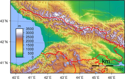
Topography
Topography of GeorgiaSatellite image of Georgia in late spring
Despite its small area, Georgia has one of the most varied topographies of the former Soviet republics.[13] It is one of the most mountainous countries in Europe,[14] lying mostly in the Caucasus Mountains, with its northern boundary partly defined by the Greater Caucasus range.[13] The Lesser Caucasus range, which runs parallel to the Turkish and Armenian borders, and the Surami Range, which connects the Greater Caucasus and the Lesser Caucasus, create natural barriers that are partly responsible for cultural and linguistic differences among regions.[13] Because of their elevation and a poorly developed transportation infrastructure, many mountain villages are virtually isolated from the outside world during the winter.[13]Earthquakes and landslides in mountainous areas present a significant threat to life and property.[13] Among the most recent natural disasters were massive rock- and mudslides in Ajaria in 1989 that displaced thousands in southwestern Georgia, and two earthquakes in 1991 that destroyed several villages in Racha, upper Imereti and the Tskhinvali Region (South Ossetia).[13]
Georgia has about 25,000 rivers, many of which power small hydroelectric stations.[13] Drainage is into the Black Sea to the west and through Azerbaijan to the Caspian Sea to the east.[13] The largest river is the Kura River, which flows 1,364km from northeast Turkey across the plains of eastern Georgia, through the capital, Tbilisi, and into the Caspian Sea.[13] The Rioni River, the largest river in western Georgia, rises in the Greater Caucasus and empties into the Black Sea at the port of Poti.[13] Soviet engineers turned the river lowlands along the Black Sea coast into prime subtropical agricultural land, embanked and straightened many stretches of river, and built an extensive system of canals.[13] Deep mountain gorges form topographical belts within the Greater Caucasus.[13]
Coastline
Svaneti region, northwestern GeorgiaBlack Sea coast of western Georgia, with the skyline of Batumi on the horizon.
The coastline of Georgia about 315 kilometres (196mi):[15] of the coastline, 57 kilometres (35mi) is the coastline of Ajaria (Ajara)[16] and 200 kilometres (120mi) is the coastline of Abkhazia.[17] Georgia has an Exclusive Economic Zone of 21,946km2 (8,473sqmi) in the Black Sea.
Climate
Köppen climate classification regions.
Georgia's climate is affected by temperate humid influences from the west and continental influences from the east.[13] The Greater Caucasus range moderates local climate by serving as a barrier against cold air from the north.[13] Warm, moist air from the Black Sea moves easily into the coastal lowlands from the west.[13] Climatic zones are determined by distance from the Black Sea and by altitude.[13] Along the Black Sea coast, from Abkhazia to the Turkish border, and in the region known as the Colchis Lowland inland from the coast, the dominant subtropical climate features high humidity and heavy precipitation (1,000 to 2,000mm or 39.4 to 78.7in per year; the Black Sea port of Batumi receives 2,500mm or 98.4in per year).[13] Several varieties of palm trees and citrus grow in these regions, where the midwinter average temperature is 5°C (41°F) and the midsummer average is 22°C (71.6°F).[13]
The plains of eastern Georgia are shielded from the influence of the Black Sea by mountains that provide a more continental climate.[13] Summer temperatures average 20 to 24°C (68.0 to 75.2°F), winter temperatures 2 to 4°C (35.6 to 39.2°F).[13] Humidity is lower, and rainfall averages 500 to 800mm (19.7 to 31.5in) per year.[13]Alpine and highland regions in the east and west, as well as a semi-arid region on the Iori Plateau to the southeast, have distinct microclimates.[13]
At higher elevations, precipitation is sometimes twice as heavy as in the eastern plains.[13] In the west, the climate is subtropical to about 650m (2,133ft); above that altitude (and to the north and east) is a band of moist and moderately warm weather, then a band of cool and wet conditions.[13] Alpine conditions begin at about 2,100m (6,890ft), and above 3,600m (11,811ft) snow and ice are present year-round.[13]
Climate data for Tbilisi (1991–2020 normals, extremes 1881–present)
Beginning in the 1980s, Black Sea pollution has greatly harmed Georgia's tourist industry.[13] Inadequate sewage treatment is the main cause of that condition.[13] In Batumi, for example, only 18 percent of wastewater was treated before release into the sea as of the early 1990s.[13] As of the early 1990s, an estimated 70 percent of surface water contained health-endangering bacteria to which Georgia's high rate of intestinal disease was attributed.[13]
The war in Abkhazia did substantial damage to the ecological habitats unique to that region.[13] In other respects, experts considered Georgia's environmental problems less serious than those of more industrialized former Soviet republics.[13] Solving Georgia's environmental problems was not a high priority of the national government in the post-Soviet years, however; in 1993 the minister for protection of the environment resigned to protest this inactivity.[13] In January 1994, the Cabinet of Ministers announced a new, interdepartmental environmental monitoring system to centralize separate programs under the direction of the Ministry of Protection of the Environment.[13] The system would include a central environmental and information and research agency.[13] The Green Party used its small contingent in the parliament to press environmental issues in 1993.[13]
↑ Geography of Georgia - 9th grade book; G. Chanturia, D. Kereselidze; p. 43
↑ "Caucasus - region and mountains, Eurasia". Encyclopedia Britannica. Retrieved 26 November 2018. Quote: “One widely accepted scheme draws the dividing line along the crest of the Greater Caucasus range, putting the portion of the region north of the line in Europe...another scheme identifies the Aras River and the Turkish border as the line of continental demarcation, thereby locating...Georgia in Europe.”
↑ International Geographic Encyclopaedia and Atlas. Springer: p. 273
↑ Nana Bolashvili, Vazha Neidze (eds.): The Physical Geography of Georgia, 227 pages, Springer Nature Switzerland, Cham, Switzerland, 2022, ISBN978-3-030-90752-5
↑ Encyclopædia Britannica, Asia:"The land boundary between Asia and Europe is a historical and cultural construct that has been defined variously" June 2021
↑ Histories 4.38. Cf. James Rennell, The geographical system of Herodotus examined and explained, Volume 1, Rivington 1830, p. 244
↑ Encyclopedia Britannica”, Caucasus, June 2021: “another scheme identifies the Aras River and the Turkish border as the line of continental demarcation, thereby locating Armenia, Azerbaijan, and Georgia in Europe.”
↑ European Parliament, European Parliament Resolution 2014/2717(RSP), 17 July 2014: "...pursuant to Article 49 of the Treaty on European Union, Georgia, Moldova and Ukraine – like any other European state – have a European perspective and may apply to become members of the Union…"
This page is based on this Wikipedia article Text is available under the CC BY-SA 4.0 license; additional terms may apply. Images, videos and audio are available under their respective licenses.