Geography of Hong Kong

Last updated

Districts of the Hong Kong Special Administrative Region: 1. Islands; 2. Kwai Tsing; 3. North; 4. Sai Kung; 5. Sha Tin; 6. Tai Po; 7. Tsuen Wan; 8. Tuen Mun; 9. Yuen Long; 10. Kowloon City; 11. Kwun Tong; 12. Sham Shui Po; 13. Wong Tai Sin; 14. Yau Tsim Mong; 15. Central & Western; 16. Eastern; 17. Southern; 18. Wan Chai Map of Hong Kong 18 Districts en.svg
Districts of the Hong Kong Special Administrative Region: 1. Islands; 2. Kwai Tsing; 3. North; 4. Sai Kung; 5. Sha Tin; 6. Tai Po; 7. Tsuen Wan; 8. Tuen Mun; 9. Yuen Long; 10. Kowloon City; 11. Kwun Tong; 12. Sham Shui Po; 13. Wong Tai Sin; 14. Yau Tsim Mong; 15. Central & Western; 16. Eastern; 17. Southern; 18. Wan Chai

The Hong Kong Special Administrative Region (HKSAR), can be divided into three geographical regions: Hong Kong Island, Kowloon (comprising the Kowloon Peninsula and New Kowloon), and the New Territories (including the Outlying Islands). Hong Kong is a coastal city and major port in Southern China, bordering Guangdong Province through the city of Shenzhen to the north and the South China Sea to the east, south, and west. Hong Kong and its 260 nearby islands and peninsulas are located at the mouth of the Pearl River Delta. The area of Hong Kong is distinct from Mainland China, but is considered a part of "Greater China".

Contents

Hong Kong has a total area of 1,108 km2 (428 sq mi), of which 3.16% is water. 60 islands are dispersed around Hong Kong, the largest of which by area is Lantau Island, located southwest of the main peninsula. Lantau Island and the majority of the remaining islands are parts of the New Territories, an area that also encompasses the hilly terrain north of Kowloon. Hong Kong Island is separated from Kowloon by Victoria Harbour, a natural harbour. The Kowloon Peninsula to the south of Boundary Street, and New Kowloon and the New Territories to the north of Boundary Street were added to British Hong Kong in 1860 and 1898, respectively.

Further from Victoria Harbour and the coast, the landscape of Hong Kong is fairly hilly to mountainous with steep slopes. The highest point in the territory is Tai Mo Shan, at a height of 958 metres in the New Territories. [1] Lowlands exist in the northwestern part of the New Territories. Portions of land on Hong Kong Island and the New Territories are reserved as country parks and nature reserves.

With the fourth-highest population density in the world at 6,300 people per square kilometre, Hong Kong is known for its shortage of residential space. Hong Kong has undergone several land reclamation projects to provide more space for residential and economic purposes, increasing its land area. This has caused the distance between Hong Kong Island and Kowloon to decrease. Hong Kong International Airport is the sole public airport in the territory, and is mostly located on reclaimed land on the island of Chek Lap Kok.

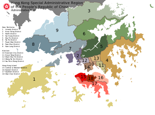
Politically, Hong Kong is divided into 18 districts, each having a district council. Nevertheless, most public services operate across the territory, and travel between the districts is not restricted. Sha Tin is the most populous district as of 2019.

The name "Hong Kong", literally meaning "fragrant harbour", is derived from the area around present-day Aberdeen on Hong Kong Island, where fragrant wood products and incense were once traded. [2] The narrow body of water separating Hong Kong Island and Kowloon Peninsula, Victoria Harbour, is one of the deepest natural maritime ports in the world.

Hong Kong is 60 km (37 mi) east of Macau, on the opposite side of the Pearl River estuary. Hong Kong and Macau are connected through the Hong Kong–Zhuhai–Macau Bridge.

Climate

Hong Kong's climate is subtropical and monsoonal (Köppen: Cwa), with cool dry winters and hot and wet summers. As of 2006, its annual average rainfall is 2,214 mm (87.2 in), though about 80% of the rain falls between May and September. It is occasionally affected by tropical cyclones between May and November, most often from July to September. The mean temperature of Hong Kong ranges from 17 °C (62.6 °F) in January and February to 29 °C (84.2 °F) in July and August. [3]

January and February are cloudier, with occasional cold fronts followed by dry northerly winds. It is not uncommon for temperatures to drop below 10 °C (50 °F) in urban areas. Sub-zero temperatures and frost occur at times on high ground and in the New Territories. March and April can be pleasant although there are occasional spells of high humidity. Fog and drizzle are common on high ground which is exposed to the southeast. May to August are hot and humid with occasional showers and thunderstorms. Afternoon temperatures often exceed 31 °C (87.8 °F) whereas at night, temperatures generally remain around 26 °C (78.8 °F) with high humidity. In November and December there are pleasant breezes, plenty of sunshine and comfortable temperatures. [4]

Geographical information

Location

Satellite Image of Hong Kong Hong Kong anotated zh.gif
Satellite Image of Hong Kong
Location of Hong Kong with respect to the Pearl River Delta Hong Kong Location.png
Location of Hong Kong with respect to the Pearl River Delta
Map showing Hong Kong and surrounding cities Pearl River Delta Area.png
Map showing Hong Kong and surrounding cities
Hong Kong borders the city of Shenzhen in Guangdong Province (1954) Hk-map.png
Hong Kong borders the city of Shenzhen in Guangdong Province (1954)
Map including Hong Kong and surrounding region from the International Map of the World (1955) Txu-oclc-6654394-nf-50-7th-ed.jpg
Map including Hong Kong and surrounding region from the International Map of the World (1955)
Map including Hong Kong and surrounding region (DMA, 1984) Operational Navigation Chart J-11, 12th edition.jpg
Map including Hong Kong and surrounding region (DMA, 1984)
Enlargeable, detailed map of the Hong Kong SAR HongKong2021OSM.png
Enlargeable, detailed map of the Hong Kong SAR

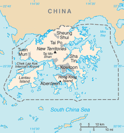
Hong Kong is on China's southern coast, 60 km (37 mi) east of Macau, on the east side of the mouth of the Pearl River estuary. It is surrounded by the South China Sea on all sides except the north, which neighbours the Guangdong city of Shenzhen along the Sham Chun River. The territory's 2,755 km2 (1,064 sq mi) area consists of Hong Kong Island, the Kowloon Peninsula, the New Territories, Lantau Island, and over 200 other islands. Of the total area, 1,073 km2 (414 sq mi) is land and 35 km2 (14 sq mi) is water. [5] The territory's highest point is Tai Mo Shan, 957 metres (3,140 feet) above sea level. [6] Urban development is concentrated on the Kowloon Peninsula, Hong Kong Island, and in new towns throughout the New Territories. [7] Much of this is built on reclaimed land, due to the lack of developable flat land; 70 km2 (27 sq mi) (six per cent of the total land or about 25 per cent of developed space in the territory) is reclaimed from the sea. [8]

Undeveloped terrain is hilly to mountainous, with very little flat land, and consists mostly of grassland, woodland, shrubland, or farmland. [9] [10] About 40 per cent of the remaining land area is country parks and nature reserves. [11] The territory has a diverse ecosystem; over 3,000 species of vascular plants occur in the region (300 of which are native to Hong Kong), and thousands of insect, avian, and marine species. [12] [13]

Land boundaries

Total:30 km (19 mi)
Border city: Shenzhen Special Economic Zone, Guangdong Province
Figures published by the United States Central Intelligence Agency [1]

Coastline

Total:733 km (455 mi)
Maritime claims:
Territorial sea:3 nautical miles (5.6 km; 3.5 mi)
Figures published by the United States Central Intelligence Agency [1]

Islands

Hong Kong has 263 islands over 500 m2 (5,400 sq ft), [14] including Hong Kong Island, Lantau Island, Cheung Chau, Lamma Island, Peng Chau and Tsing Yi Island.

Terrain

Hong Kong's terrain is hilly and mountainous with steep slopes. There are lowlands in the northern part of Hong Kong. A significant amount of land in Hong Kong, especially on the Hong Kong Island and the Kowloon peninsula, is reclaimed.

Extreme points

The lowest elevation in Hong Kong is in the South China Sea (0 m)[ dubious ] while the highest elevation is at Tai Mo Shan (957 m (3,140 ft)) in Tsuen Wan, the New Territories.

Land

Principal peaks of Hong Kong

  1. Tai Mo Shan - 957 m (3,140 ft), Tsuen Wan
  2. Lantau Peak (Fung Wong Shan) - 934 m (3,064 ft) on Lantau Island
  3. Sunset Peak (Tai Tung Shan) - 869 m (2,851 ft), on Lantau Island
  4. Sze Fong Shan - 785 m (2,575 ft)
  5. Lin Fa Shan - 766 m (2,513 ft), on Lantau Island
  6. Nei Lak Shan - 751 m (2,464 ft), on Lantau Island
  7. Yi Tung Shan - 747 m (2,451 ft), on Lantau Island
  8. Ma On Shan - 702 m (2,303 ft)
  9. The Hunch Backs (Ngau Ngak Shan) - 674 m (2,211 ft)
  10. Grassy Hill - 647 m (2,123 ft)
  11. Wong Leng - 639 m (2,096 ft)
  12. Buffalo Hill - 606 m (1,988 ft)
  13. West Buffalo Hill - 604 m (1,982 ft)
  14. Kowloon Peak (Fei Ngo Shan) - 602 m (1,975 ft)
  15. Shun Yeung Fung - 591 m (1,939 ft)
  16. Tiu Shau Ngam - 588 m (1,929 ft)
  17. Kai Kung Leng - 585 m (1,919 ft)
  18. Castle Peak - 583 m (1,913 ft)
  19. Lin Fa Shan, Tsuen Wan - 578 m (1,896 ft)
  20. Tate's Cairn (Tai Lo Shan) - 577 m (1,893 ft)

Victoria Peak, the highest point on Hong Kong Island, at 552 m (1,811 ft) is the 24th highest peak in Hong Kong.

Natural resources

The natural resources of Hong Kong can be divided into three main categories:

Despite its small size, Hong Kong has a relatively large number of mineral occurrences. Some mineral deposits have been exploited commercially. Metalliferous mineral occurrences are grouped into four broad categories: tin-tungsten-molybdenum mineralisation, copper-lead-zinc mineralisation, iron mineralisation and placer deposits of tin and gold. Mesozoic igneous activity is largely responsible for this diversity of mineral deposits and the mineral concentrations have been variably enhanced by hydrothermal activity associated with faulting. Concentrations of non-metalliferous minerals that have been commercially exploited include kaolin clay, feldspar, quartz, beryl and graphite. [15]

For many years, granite and volcanic rocks have been quarried locally for road base metal, riprap, armour stone and asphalt, although the main purpose now is for concrete aggregates. At present, there are three quarries operating in Hong Kong. These are principally in granite and are located at Lam Tei, Shek O and Anderson Road. All the quarries are in the process of rehabilitation and have a life expectancy of between two and eight years. [15]

Offshore sand bodies have been dredged for aggregate sand and reclamation fill in Hong Kong as the rate of urban development has increased. [16]

Additional natural resources include forest and wildlife.

Land use

Arable land: 2.95%
Permanent crops: 0.95%
Other: 96.10% (2012 est.)
Figures published by the United States Central Intelligence Agency [1] Big 22

Natural hazards

Tropical cyclones are frequent in Hong Kong during the summer months between June and August. Landslides are common after rainstorms.

Environmental issues

See also

Related Research Articles

<span class="mw-page-title-main">Transport in Hong Kong</span> Overview of the transport in Hong Kong

Hong Kong has a highly developed transport network, encompassing both public and private transport. Based on Hong Kong Government's Travel Characteristics Survey, over 90% of daily journeys are on public transport, the highest rate in the world. However, in 2014 the Transport Advisory Committee, which advises the Government on transportation issues, issued a report on the much-worsened congestion problem in Hong Kong and pointed at the excessive growth of private cars during the past 10–15 years.

<span class="mw-page-title-main">Peng Chau</span> Island in Hong Kong

Peng Chau is a small island located off the north-eastern coast of Lantau Island, Hong Kong. It is known locally for its temples, fishing industry and seafood.

<span class="mw-page-title-main">Hong Kong Island</span> Second largest island in Hong Kong

Hong Kong Island is an island in the southern part of Hong Kong. Known colloquially and on road signs simply as Hong Kong, the island had a population of 1,289,500 and a population density of 16,390 per square kilometre (42,400/sq mi), as of 2008. The island had a population of about 3,000 inhabitants scattered in a dozen fishing villages when it was occupied by the United Kingdom in the First Opium War (1839–1842). In 1842, the island was formally ceded in perpetuity to the UK under the Treaty of Nanking and the City of Victoria was then established on the island by the British Force in honour of Queen Victoria. The Central area on the island is the historical, political and economic centre of Hong Kong. The northern coast of the island forms the southern shore of the Victoria Harbour, which is largely responsible for the development of Hong Kong due to its deep waters favoured by large trade ships.

<span class="mw-page-title-main">Lantau Island</span> Largest island in Hong Kong

Lantau Island is the largest island in Hong Kong, located West of Hong Kong Island and the Kowloon Peninsula, and is part of the New Territories. Administratively, most of Lantau Island is part of the Islands District of Hong Kong. A small northeastern portion of the island is located in the Tsuen Wan District.

<span class="mw-page-title-main">Kowloon</span> Area of Hong Kong

Kowloon is an urban area in Hong Kong comprising the Kowloon Peninsula and New Kowloon. With a population of 2,019,533 and a population density of 43,033/km2 (111,450/sq mi) in 2006, it is the most populous area in Hong Kong, compared with Hong Kong Island and the rest of the New Territories. The peninsula's area is about 47 km2 (18 sq mi).

<span class="mw-page-title-main">Islands District</span> District in Hong Kong, China

The Islands District is one of the 18 districts of Hong Kong. It is part of the New Territories. It had a population of 185,282 in 2021.

<span class="mw-page-title-main">New Territories</span> Region of Hong Kong

The New Territories is one of the three main regions of Hong Kong, alongside Hong Kong Island and the Kowloon Peninsula. It makes up 86.2% of Hong Kong's territory, and contains around half of the population of Hong Kong. Historically, it is the region described in the Convention for the Extension of Hong Kong Territory. According to that treaty, the territories comprise the mainland area north of Boundary Street on the Kowloon Peninsula and south of the Sham Chun River, as well as over 200 outlying islands, including Lantau Island, Lamma Island, Cheung Chau, and Peng Chau in the territory of Hong Kong.

<span class="mw-page-title-main">Victoria Harbour</span> Harbour in Hong Kong

Victoria Harbour is a natural landform harbour in Hong Kong separating Hong Kong Island in the south from the Kowloon Peninsula to the north. The harbour's deep, sheltered waters and strategic location on South China Sea were instrumental in Hong Kong's establishment as a British colony in 1841 and its subsequent development as a trading centre.

<span class="mw-page-title-main">Ma On Shan Country Park</span> Country park in the New Territories, Hong Kong

Ma On Shan Country Park is a park located in the central neck of the Sai Kung Peninsula in the eastern New Territories of Hong Kong. The park covers an area of 28.8 square kilometres (11.1 sq mi) and links Sai Kung Country Park and Lion Rock Country Park to form an extensive recreation area on the Ma On Shan massif.

<span class="mw-page-title-main">Lion Rock Country Park</span>

Lion Rock Country Park is a country park, located in the New Territories, Hong Kong. It consists of approximately 5.57 square kilometres (2.15 sq mi) of land, including Lion Rock and Mong Fu Shek and their surrounding scenic hillsides, of which 3.48 square kilometres (1.34 sq mi) is forestry plantation.

<span class="mw-page-title-main">Tsing Yi Peak</span> Hill on Tsing Yi Island, Hong Kong

Tsing Yi Peak, also known as Sam Chi Heung, is a hill with three peaks occupying the southern half of the Tsing Yi Island, Hong Kong. The hill is situated on the western half of Victoria Harbour. Its peaks are good locations to observe the harbour and the channels among harbour islands. While situated in the south, a short hill Liu To Shan occupies the northwest of the island.

<span class="mw-page-title-main">North Lantau Highway</span> Expressway in western Hong Kong

North Lantau Highway is an expressway forming part of Hong Kong's Route 8, linking Hong Kong International Airport and Lantau Island with the rest of the territory. The road has three lanes in each direction for its entire length with full-width hard shoulders for emergencies and breakdowns. The speed limit is 110 kilometres per hour (68 mph) for most of its length, the highest of any road in Hong Kong.

<span class="mw-page-title-main">Kau Yi Chau</span>

Kau Yi Chau, also known as Tai Kau Yi Chau, is an uninhabited island located west of Victoria Harbour, between Peng Chau and Green Island in Hong Kong. It is located on the crossroad of sea routes, east to west and north to south. The ferry between Central and Mui Wo sails close to the south of the island. Administratively it is part of Islands District.

<span class="mw-page-title-main">Tai Mo Shan Road</span>

Tai Mo Shan Road is a road in New Territories, Hong Kong. It originates from Route Twisk and leads to the weather station at the top of Tai Mo Shan. Paved the whole way, the upper-most roughly 3 kilometres (1.9 mi) route is blocked by a staffed barrier gate, and is hence inaccessible to motor vehicles, except those on government or military service. A carpark exists at this point. Bicycles and pedestrians are permitted past this barrier, with cyclists not permitted to go beyond the boundaries of the paved road. There is an enclosed restricted area in which lies at 957 metres (3,140 ft), Hong Kong's highest point, a Doppler weather radar, and communications equipment.

<span class="mw-page-title-main">Geology of Hong Kong</span>

The geology of Hong Kong is dominated by igneous rocks formed during a major volcanic eruption period in the Mesozoic era. It made up 85% of Hong Kong's land surface and the remaining 15% are mostly sedimentary rocks located in the northeast New Territories. There are also a very small percentage of metamorphic rocks in the New Territories, formed by deformation of pre-existing sedimentary rocks (metamorphism).

<span class="mw-page-title-main">Land reclamation in Hong Kong</span> Reclamation of land

The reclamation of land from the ocean has long been used in mountainous Hong Kong to expand the limited supply of usable land with a total of around 60 square kilometres of land created by 1996. The first reclamations can be traced back to the early Western Han dynasty, when beaches were turned into fields for salt production. Major land reclamation projects have been conducted since the mid-19th century.

<span class="mw-page-title-main">Tai Mo Shan</span> Highest peak in Hong Kong

Tai Mo Shan is the highest peak in Hong Kong, with an elevation of 957 metres (3,140 ft) above the Hong Kong Principal Datum, or around 956 metres (3,136 ft) above mean sea level. It is located at approximately the geographical centre of the New Territories.

References

  1. 1 2 3 4 "Hong Kong" . The World Factbook. CIA. Retrieved 18 September 2009.
  2. Visit Hong Kong: Volume 1, Spring, 2004 (p.14) Archived 7 December 2006 at the Wayback Machine , University of Hong Kong English Centre.
  3. Hong Kong Survey & Mapping Office, Lands Department. Hong Kong Guide 2007 [map]. Notes on Hong Kong, p. 411. ISBN   962-567-174-9.
  4. Climate of Hong Kong Archived 17 October 2016 at the Wayback Machine Hong Kong Observatory. Retrieved on 1 September 2007.
  5. "Hong Kong". The World Factbook . Central Intelligence Agency. Archived from the original on 14 May 2009. Retrieved 2 October 2018.
  6. Owen & Shaw 2007 , p. 13.
  7. Population By-Census 2016 , pp. 34–35.
  8. Land Policy Report 2017 , p. 1.
  9. Owen & Shaw 2007 , p. 2.
  10. "Land Utilization in Hong Kong 2017", Planning Department.
  11. Morton & Harper 1995 , p. 9.
  12. Hu 2003.
  13. "The Natural Environment, Plants & Animals in Hong Kong". Government of Hong Kong. Archived from the original on 15 November 2017. Retrieved 15 November 2017.
  14. Lands Department (February 2011), Hong Kong Geographic Data (PDF), archived (PDF) from the original on 5 March 2012, retrieved 29 April 2011
  15. 1 2 R.J. Sewell; S.D.G. Campbell; C.J.N. Fletcher; K.W. Lai; P.A. Kirk (2000). The Pre-Quaternary Geology of Hong Kong. Government of Hong Kong SAR. ISBN   962-02-0299-6.
  16. J.A. Fyfe, R.Shaw, S.D.G. Campbell, K.W. Lai & P.A. Kirk (2000). The Quaternary Geology of Hong Kong. Government of Hong Kong SAR. ISBN   962-02-0298-8.{{cite book}}: CS1 maint: multiple names: authors list (link)

22°15′N114°10′E / 22.250°N 114.167°E / 22.250; 114.167