New Kowloon

Last updated

New Kowloon
新九龍
Statutorily-defined area
SNC11187.JPG
Eastern New Kowloon (Kowloon Bay, Kwun Tong, etc.)
Etymology: Name after Kowloon Peninsula
New Kowloon Map.png
Approx. location of New Kowloon (in red), compared to the Kowloon geographical constituencies of the Legislative Council (in green); note that the newer 13/31 runway of the former Kai Tak Airport reclaimed land (also coloured in green), now considered part of New Kowloon e.g. lot numbers, did not exist until the 1950s.
Region(s)New Territories / Kowloon
Special administrative region Flag of Hong Kong.svg  Hong Kong
Sovereign stateFlag of the People's Republic of China.svg  People's Republic of China
New Kowloon separated from Kowloon 1860
New Kowloon (as part of New Territories) leased to Hong Kong 1898
New Kowloon defined from part of the New Territories1900
Time zone Hong Kong Time
Chinese name
Traditional Chinese 九龍
Simplified Chinese 九龙
Cantonese Yale Sān Gáulùhng
Literal meaningNew Nine Dragons

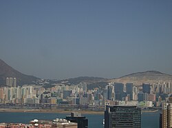
New Kowloon is an area in Hong Kong, bounded to the south by Boundary Street, and to the north by the ranges of the Eagle's Nest, Beacon Hill, Lion Rock, Tate's Cairn and Kowloon Peak. It covers the present-day Kwun Tong District and Wong Tai Sin District, and northern parts of the Sham Shui Po District and Kowloon City District.

Contents

The name of this area is[ when? ] rarely used in day to day life. Areas that belongs to New Kowloon are usually referred to as part of Kowloon. However, in land leases, it is common to refer to land lots in lot numbers as "New Kowloon Inland Lot number #".

History

By the Convention of Peking in 1860, the territory of British-owned Kowloon was defined as area in Kowloon Peninsula south of Boundary Street (known as Kowloon, inclusive of Stonecutter's Island), which was ceded by the Qing Empire (Ch'ing Empire, Manchu Empire) to the United Kingdom under the Convention.

On the other hand, the territory north of Boundary Street (later known as New Kowloon) remained part of Qing Empire until it was leased as part of the New Territories to the UK in 1898 for 99 years under the Convention for the Extension of Hong Kong Territory (also known as the Second Convention of Peking). The area of New Kowloon was defined in statutory law first in November 1900 [1] [2] (and referred to as such [3] [4] [5] [6] [7] [8] [9] [10] ) and again in December 1937 [11] [12] [13] to increase land available for urban development.[ citation needed ] In practice, nevertheless, both the areas to the south and to the north of Boundary Street (i.e. both Kowloon and New Kowloon), from the Lei Yue Mun strait in the east to Mei Foo Sun Chuen and Lai Chi Kok Bay in the west, are collectively known as "Kowloon". For example, a postal address in Kwun Tong will identify "Kowloon" as its regional destination, even though it is technically in New Kowloon and not part of Kowloon as statutorily defined.

Current situation

In modern-day conversations, the term "New Kowloon" is now[ when? ] rarely heard in Hong Kong. New Kowloon is no longer regarded as part of the New Territories, but as a part of the Kowloon urban area beyond Boundary Street. Nevertheless, the legal definitions of Kowloon, New Kowloon and New Territories remain unchanged—New Kowloon has remained legally part of the New Territories instead of Kowloon. [14] On 1 July 1997, the territories on both sides of Boundary Street (ceded and leased respectively) were transferred to China, along with the rest of Hong Kong.

However, the designation "New Kowloon" still has some legal implications. Almost all lands of Hong Kong are government land (known as crown land in Commonwealth countries and before 1997 in Hong Kong), while all crown leases (now known as government leases in Hong Kong) of New Kowloon and New Territories lands had been expired on 27 June 1997, but automatically extended up to 30 June 2047 due to the Sino-British Joint Declaration. [15] This renewal implies that, all privately owned land leases of New Kowloon, has to pay government rent (crown rent in Commonwealth countries) as leases in the rest of the New Territories, and unlike the rest of the Kowloon. [16] Most Kowloon land leases (Kowloon south of the Boundary Street) are not required to pay the government rent to the government, unless they are new leases, or are old leases having been renewed and such clauses have been inserted in the renewed lease contract.

The land reclaimed from the Kowloon Bay water body, such as Kai Tak, are also referred as part of New Kowloon in land leases, [17] [18] although these lots do not appear to be included in the 1937 map.

See also

Related Research Articles

<span class="mw-page-title-main">Hong Kong</span> Special administrative region of the Peoples Republic of China

Hong Kong is a city and a special administrative region in China. With 7.4 million residents of various nationalities in a 1,104-square-kilometre (426 sq mi) territory, Hong Kong is one of the most densely populated territories in the world.

<span class="mw-page-title-main">Districts of Hong Kong</span> Peoples Republic of China prefecture-level subdivision used in Hong Kong

The districts of Hong Kong are the 18 political areas of Hong Kong, a special administrative region of the People's Republic of China, that are geographically and administratively divided. Under the one country, two systems concept, each district has a district council, formerly district boards, for which the boards were established in 1982, when Hong Kong was under British rule. However, the districts have limited relevance to the population, as few public services operate according to district boundaries. The police, fire services, health services, education and hospital authorities, and postal service each define their own idiosyncratic geographic divisions.

<span class="mw-page-title-main">Kowloon</span> Area of Hong Kong

Kowloon is an urban area in Hong Kong comprising the Kowloon Peninsula and New Kowloon. It has a population of 2,019,533 and a population density of 43,033/km2 (111,450/sq mi) in 2006. It is one of the three regions of Hong Kong, along with Hong Kong Island and the New Territories, and is the smallest and most densely populated.

<span class="mw-page-title-main">New Territories</span> Region of Hong Kong

The New Territories is one of the three main regions of Hong Kong, alongside Hong Kong Island and the Kowloon Peninsula. It makes up 86.2% of Hong Kong's territory, and contains around half of the population of Hong Kong. Historically, it is the region described in the Convention for the Extension of Hong Kong Territory. According to that treaty, the territories comprise the mainland area north of Boundary Street on the Kowloon Peninsula and south of the Sham Chun River, as well as over 200 outlying islands, including Lantau Island, Lamma Island, Cheung Chau, and Peng Chau in the territory of Hong Kong.

<span class="mw-page-title-main">Convention of Peking</span> 1860 unequal treaty between Qing China and Britain, France, and Russia

The Convention of Peking or First Convention of Peking is an agreement comprising three distinct treaties concluded between the Qing dynasty of China and Great Britain, France, and the Russian Empire in 1860. In China, they are regarded as among the unequal treaties.

<span class="mw-page-title-main">Kowloon-Canton Railway Corporation</span>

The Kowloon-Canton Railway Corporation is a Hong Kong wholly government-owned railway and land asset manager. It was established in 1982 under the Kowloon-Canton Railway Corporation Ordinance for the purposes of operating the Kowloon–Canton Railway (KCR), and to construct and operate other new railways. On 2 December 2007, the MTR Corporation Limited (MTRCL), another railway operator in Hong Kong, took over the operations of the KCR network under a 50-year service concession agreement, which can be extended. Under the service concession, KCRC retains ownership of the KCR network with the MTRCL making annual payments to KCRC for the right to operate the network. The KCRC's activities are governed by the KCRC Ordinance as amended in 2007 by the Rail Merger Ordinance to enable the service concession agreement to be entered into with the MTR Corporation Limited.

<span class="mw-page-title-main">Kwun Tong</span> Region in Hong Kong

Kwun Tong is an area in the Kwun Tong District of Hong Kong, situated at the eastern part of the Kowloon Peninsula, and its boundary stretches from Lion Rock in the north to Lei Yue Mun in the south, and from the winding paths of Kowloon Peak in the east to the north coast of the former Kai Tak Airport runway in the west.

<span class="mw-page-title-main">Kowloon Bay</span>

Kowloon Bay is a body of water within Victoria Harbour and an area within Kowloon, Hong Kong.

<span class="mw-page-title-main">Victoria, Hong Kong</span> Historical city in Hong Kong

The City of Victoria, often called Victoria City or simply Victoria, was the de facto capital of Hong Kong during its time as a British dependent territory. It was initially named Queenstown but was soon known as Victoria. It was one of the first urban settlements in Hong Kong and its boundaries are recorded in the Laws of Hong Kong. All government bureaux and many key departments still have their head offices located within its limit.

<span class="mw-page-title-main">Kowloon Tong</span> Area in Kowloon, Hong Kong

Kowloon Tong (Chinese: 九龍塘) is an area of Hong Kong located in Kowloon. The majority of the area is in the Kowloon City District. Its exact location is south of the Lion Rock, north of Boundary Street, east of the East Rail line and west of Grampian Road. It is one of the most expensive residential districts in Hong Kong.

<span class="mw-page-title-main">Boundary Street</span> Street in Kowloon, Hong Kong

Boundary Street is a three-lane one-way street in Kowloon, Hong Kong. It runs in an easterly direction from its start at the intersection with Tung Chau Street in the west, and ends at its intersection with Prince Edward Road West in the east, near the former Kai Tak Airport.

<span class="mw-page-title-main">Kwun Tong Bypass</span>

The Kwun Tong Bypass is an elevated expressway between Lam Tin and Kowloon Bay in Kwun Tong District, Kowloon East, Hong Kong, with three lanes in each direction and a posted speed limit of 70–80 kilometres per hour (43–50 mph). It is part of Route 2 and has links to Route 5 and Route 7. It bypasses the industrial township of Kwun Tong and passes next to the boundary of the Kai Tak Airport.

<span class="mw-page-title-main">Kowloon City District</span> District in Hong Kong, China

Kowloon City District is one of the 18 districts of Hong Kong. It is located in the city of Kowloon. It had a population of 381,352 in 2001, and increased to 418,732 in 2016. The district has the third most educated residents while its residents enjoy the highest income in Kowloon. It borders all the other districts in Kowloon, with Kwun Tong district to the east, Wong Tai Sin district to its northeast, Sham Shui Po district to its northwest, and Yau Tsim Mong district to its southwest.

<span class="mw-page-title-main">Convention for the Extension of Hong Kong Territory</span> 1898 treaty between China and the United Kingdom

The Convention between the United Kingdom and China, Respecting an Extension of Hong Kong Territory, commonly known as the Convention for the Extension of Hong Kong Territory or the Second Convention of Peking, was a lease signed between Qing China and the United Kingdom in Peking on 9 June 1898, leasing to the United Kingdom for 99 years, at no charge, the New Territories and northern Kowloon, including 235 islands.

Establishment Day, formally the Hong Kong Special Administrative Region Establishment Day, is celebrated annually on 1 July in Hong Kong, China since 1997. The holiday celebrates the transfer of sovereignty over Hong Kong from the United Kingdom to the People's Republic of China and the establishment of the Hong Kong Special Administrative Region. The similarly-named holiday in Macau occurs on 20 December, the day of its handover from Portugal.

<span class="mw-page-title-main">Hong Kong Strategic Route and Exit Number System</span> Trunk road numbering system in Hong Kong

The Hong Kong Strategic Route and Exit Number System is a system adopted by the Transport Department of the Hong Kong Government to organise the major roads in the territory into routes 1 to 10 for the convenience of drivers. When the system was implemented in 2004, the government promoted it with a major public campaign, including the slogan "Remember the Numbers; Make Driving Easier".

<span class="mw-page-title-main">Shenzhen Bay Port</span> Port of entry between Hong Kong and China

Shenzhen Bay Port is a juxtaposed border crossing and a port of entry and exit between mainland China and the Hong Kong Special Administrative Region, located geographically in Dongjiaotou, Shekou, which lies on the southwestern corner of the city of Shenzhen in Guangdong Province.

Government rent in Hong Kong started on July 1, 1997, with the inception of the Joint Declaration. It said that new land grants contain a standard condition that the lessee is required to pay an annual rent, equal to 3% of the rateable value from time to time of the land leased.

<span class="mw-page-title-main">Kwun Tong Promenade</span> Harbourfront park in Kwun Tong, Hong Kong

Kwun Tong Promenade is an urban waterfront park in Kwun Tong, New Kowloon, Hong Kong. The first and second stages of the promenade, opened in 2010 and 2015 respectively, comprise the first open space project of the Kai Tak Development. The promenade is about one kilometre in length. It overlooks the Kwun Tong Typhoon Shelter and sits beneath the Kwun Tong Bypass.

<span class="mw-page-title-main">Boundaries of Hong Kong</span> Regulated administrative border

The Boundaries of Hong Kong, officially the Boundary of the Administrative Division of the Hong Kong Special Administrative Region of the People's Republic of China, is a regulated administrative border with border control in force under the One country, two systems constitutional principle, which separates the Hong Kong Special Administrative Region from mainland China, by land border fence of 30 km (19 mi) and maritime boundary of 733 km (455 mi), enforcing a separate immigration and customs-controlled jurisdiction from mainland China.

References

  1. New Territories (Extension of Laws) Ordinance 1900, Ordinance No. 8 of 1900
  2. Plan of New Kowloon, signed by the Director of Public Works and countersigned by the Governor and deposited in the Land Office of the Colony, and deposited at the Magistracy and at the Office of the Colonial Secretary according to the New Territories (Extension of Laws) Ordinance 1900
  3. Hong Kong Legislative Council
  4. Administrative Reports for the Year 1909
  5. Hong Kong Legislative Council
  6. Hong Kong Legislative Council
  7. Hong Kong Legislative Council
  8. "HK Maps". Archived from the original on 10 July 2019.
  9. "HK Maps". Archived from the original on 4 November 2018.
  10. "HK Maps". Archived from the original on 30 June 2017.
  11. Hong Kong Legislative Council
  12. Sched 5 to the IGCO
  13. Plan marked “New Kowloon” dated 8 December 1937, signed by the Director of Public Works, countersigned by the Governor and deposited in the Land Registry.
  14. Schedules 4, 5 and 5A, Interpretation and General Clauses Ordinance (IGCO), HK Law Cap. 1
  15. Annex III, Sino-British Joint Declaration  via Wikisource.
  16. "Government Rent". Hong Kong: Rating and Valuation Department. 1 August 2019. Retrieved 6 December 2020.
  17. "Government to sell site in Kai Tak by public tender". info.gov.hk (Press release). Hong Kong Government. 23 October 2020. Retrieved 3 December 2020.
  18. https://hos.housingauthority.gov.hk/mini-site/hos2022/common/pdf/DMC_Kai_Yan_Court.pdf https://hos.housingauthority.gov.hk/mini-site/hos2022/common/pdf/brochure/Sales_Brochure_Kai_Yan.pdf

22°20′03″N114°11′14″E / 22.3341°N 114.1871°E / 22.3341; 114.1871