
Most of the walled villages of Hong Kong are located in the New Territories.

Tsang Tai Uk, also known as Shan Ha Wai, is a Hakka walled village in Hong Kong, and one of the best preserved. The complex is located in Sha Tin close to the south of Pok Hong Estate, near Lion Rock Tunnel Road.

Tsz Wan Shan is a residential area in Kowloon, Hong Kong. Located below Temple Hill, it is administratively part of Wong Tai Sin District. Temple Hill is also called Tsz Wan Shan 慈雲山, but Tsz Wan Shan usually refers to the area.
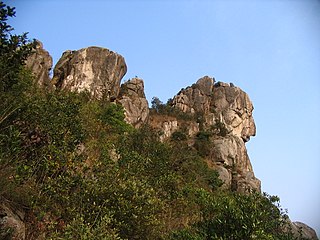
Lion Rock, or less formally Lion Rock Hill, is a mountain in Hong Kong. It is located in Sha Tin District, between Kowloon Tong of Kowloon and Tai Wai of the New Territories, and is 495 metres (1,624 ft) high. The peak consists of granite covered sparsely by shrubs. The Kowloon granite, which includes Lion Rock, is estimated to be around 140 million years old.

Sha Tin, also spelt Shatin, is a neighbourhood along Shing Mun River in the eastern New Territories, Hong Kong. Administratively, it is part of the Sha Tin District. Sha Tin is one of the neighbourhoods of the Sha Tin New Town project.

Tuen Mun or Castle Peak is an area near the mouth of Tuen Mun River and Castle Peak Bay in the New Territories, Hong Kong. It was one of the earliest settlements in what is now Hong Kong and can be dated to the Neolithic period. In the more recent past, it was home to many Tanka fishermen who gathered at Castle Peak Bay. Tuen Mun is now a modern, mainly residential area in the north-west New Territories. As of 2011, 487,546 residents live in Tuen Mun.

Temple Hill, also known as Tsz Wan Shan, is a hill between New Kowloon and the New Territories, Hong Kong. It peaks at 488 m. Beneath its south side is the residential area of Tsz Wan Shan and Buddhist temples. Sha Tin Pass runs between the hill and Unicorn Ridge. The summit of the hill is located within Sha Tin District.

Kau To Hang is a river in Sha Tin District, New Territories, Hong Kong. Its source starts near Cheung Lek Mei, inside Tai Po Kau Nature Reserve. It flows eastward past Nim Au, Ma Niu, Kau To, collecting minor streams on the way. Finally, it empties into Sha Tin Hoi, part of Tolo Harbour.
Eagle's Nest, also known indigenously as Tsim Shan (尖山), is a hill north of Cheung Sha Wan of Hong Kong. The hill is located within Lion Rock County Park, and administratively part of Sha Tin District with border to Sham Shui Po District at her south. The hill peaks at 305 metres and is within. The hill is located northeast of Piper's Hill and northwest of Crow's Nest.

Tao Fong Shan, officially known as To Fung Shan, is a hill with a height of 130 metres (430 ft). It is in Sha Tin, New Territories, Hong Kong. A road called To Fung Shan Road leads to the summit, where a Christian Centre can be found.

Tin Sam Village or Tin Sam Tsuen, sometimes transliterated as Tin Sum, is a village in Tai Wai, Sha Tin District, Hong Kong. It is located west of Sun Chui Estate, north of Lung Hang Estate, and southeast of Festival City. Part of Tin Sam Village consists of Tin Sam Wai (田心圍), a historic walled village.

Tin Ha Shan is a hill in Clear Water Bay Country Park, Sai Kung District, Hong Kong.

Turret Hill, also known as Nui Po Shan, is a peak southeast of Tolo Harbour in the New Territories of Hong Kong. It has a height of 399 metres. The mountain is located in the Sha Tin District.

Por Lo Shan is a 121 m (397 ft) high peak in the western New Territories of Hong Kong.

Ma Niu Village, sometimes spelled Ma Liu, is a village on Kau To Shan, near Fo Tan, Sha Tin District, Hong Kong.

Kau To Village is a village on Kau To Shan, near Fo Tan, Sha Tin District, Hong Kong.
The Nine Alliances of Lek Yuen or Kau Yeuk was a regional organization of various groups in Sha Tin Valley, Hong Kong.
Fu Yung Pei aka. Fu Yung Pit (芙蓉別) is a village in Sha Tin District, Hong Kong.


