Shek Kip Mei

Last updated

Shek Kip Mei
Shek Kip Mei Buildings 2009.jpg
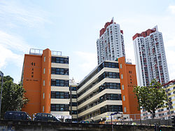
Shek Kip Mei in 2009

The Government has backed off from its plans to redevelop the area, following great opposition from many who believe they symbolised the history of Hong Kong. An alternative plan to renovate it for use as a hostel and museum has been completed. The museum includes restored rooms, resident stories and photos, and documentation of the history of public housing estates.

Shek Kip Mei now has several types of housing including the public apartments, Pak Tin Estate and private housing such as Beacon Heights and Dynasty Heights. Several malls and churches can also be found in the area now.

The old Shek Kip Mei Factory Estate was renovated and now serves as the Jockey Club Creative Arts Centre.

Transportation

Since 1 October 1979, it has been served by Shek Kip Mei station on the MTR at Woh Chai Street and Wai Chi Street.

Route 7 passes to the north of the area and accessed via Nam Cheong Street.

KMB and New World First Bus operates a number or routes that travel within the area.

Education

Shek Kip Mei is in Primary One Admission (POA) School Net 40. Within the school net are multiple aided schools (operated independently but funded with government money) and two government schools: Fuk Wing Street Government Primary School and Li Cheng Uk Government Primary School. [6]

See also

References

  1. Hase, Patrick (1996). "Traditional Life in the New Territories: The Evidence of the 1911 and 1921 Censuses" (PDF). Journal of the Royal Asiatic Society Hong Kong Branch . 36: 83. ISSN   1991-7295.
  2. Wiltshire, Trea. [First published 1987] (republished & reduced 2003). Old Hong Kong – Volume Three. Central, Hong Kong: Text Form Asia books Ltd. Page 7. ISBN Volume Three 962-7283-61-4
  3. Smart, Alan. (2006). The Shek Kip Mei Myth: Squatters, Fires And Colonial Rulers in Hong Kong, 1950–1963.
  4. Tai Wo Ping Cottage Area Archived 21 July 2011 at the Wayback Machine
  5. Hong Kong in the Post War Years Archived 21 November 2008 at the Wayback Machine
  6. "POA School Net 40" (PDF). Education Bureau . Retrieved 12 September 2022.

22°20′03″N114°10′08″E / 22.33426°N 114.16881°E / 22.33426; 114.16881