Ma Liu Shui

Last updated

Ma Liu Shui
馬料水
Ma Liu Shui Aerial view 201712.jpg
Ma Liu Shui
Coordinates: 22°24′59″N114°12′32″E / 22.41639°N 114.20889°E / 22.41639; 114.20889
CountryFlag of Hong Kong.svg  Hong Kong
Region New Territories
District Sha Tin District
District Council Sha Tin

Name etymology

Ma Liu Shui
Traditional Chinese 馬料水

Ma Liu Shui is directly and phonetically translated to English from "馬料水" in Cantonese. It literally means "the water that the horses feed on". It was originally named "馬嫽水", with the same phonetic translation, literally meaning "the water that the horses play in".

According to legend of Hakkas, hundreds of years ago when the government of Bao'an County was riding his horse around towns to announce the collection of rice and crops, the horse stopped in the area and went down the hills to drink and play in the lake. It would not leave and looked as if it were at home. The Hakka villagers observed this strange phenomena and cleverly suggested that the horse may have originated from there, therefore the sense of belonging. They named the area "馬嫽水", which translates to "Ma Liu Shui" because of this.

History

Ma Liu Shui was a barren land inhabited by Hakkas until in 1956, Chung Chi College was allowed 10 acres of land in Ma Liu Shui to build their campus upon, [1] alongside opened a KCR station also named 'Ma Liu Shui station' [2] for people's convenience.

In 1963, Chinese University of Hong Kong was established, setting its campus in Ma Liu Shui. [3] Chung Chi College was therefore expanded, the original KCR station renamed as University station. Ma Liu Shui Village was relocated to its present site in between Lung Yeuk Tau and Kwan Tei, belonging to the Rural committee of Fanling district, and was renamed 'Ma Liu Shui San Tsuen', literally meaning the new village of Ma Liu Shui. In the same year, Yucca de Lac had opened near the Chinese University of Hong Kong. [4]

In between 1969 and 1973, the various academic buildings of CUHK and New Asia and United College moved into their new premises next to Chung Chi College.

During the 1980s, University station (MTR) became a main transit station for locals because of the redevelopment of the new town in Ma On Shan. The opening of Ma On Shan line in December 2004 helped dilute the crowds and its importance.

In 2005, Yucca de Lac was closed down. [5]

Another familiar landmark is the ferry dock in Ma Liu Shui. It has the only ferry service connecting the public to Tung Ping Chau, at the same time serving as the gathering spot for sightseeing trips to the coasts of New Territories, which explains its popularity on the weekends. It also had had a hovercraft service crossing the borders to Dameisha Beach, Shenzhen in the early 1980s, which had been closed down.

Landmarks

Education

Ma Liu Shui is in Primary One Admission (POA) School Net 91. Within the school net are multiple aided schools (operated independently but funded with government money); no government schools are in this net. [7]

Tertiary institutions in Ma Liu Shui:

Restaurants

Restaurants in Ma Liu Shui spread mainly in 2 area: up on the hill inside the Chinese University of Hong Kong (CUHK) campus, and the Science Park along to coast. In between these 2 areas, tourist may also find a dining option in the Kerry Lake Egret Nature Park (白鷺湖互動中心).

A large group of small restaurants and canteens can also be found inside the Chinese University of Hong Kong campus to serve both the students and staff. A Maxim fastfood can be found in the University Station, whereas a McCafe can be located in Shaw College. New Asia College campus has a Chinese dumpling restaurant. Newer colleges also has quite a number of new food stalls which offers ox tail soup, fish balls and sushi rolls.

A KFC is also available in Chung Chi College campus.

Transport

University station in 2010. HK ER UniversityStation.JPG
University station in 2010.

MTR

There is an East Rail line station in Ma Liu Shui just by the Chinese University of Hong Kong. The station was originally known as Ma Liu Shui Station, but was later renamed University station. This is also because the Chinese University of Hong Kong is more well-known than the name "Ma Liu Shui". The Cantonese phonetics also had significant similarities with Ma Niu Shui (馬尿水), prompting the successful lobby of its name change in 1967. The station sign was changed on 1 January 1967. The MTR plans to build another station called "Science Park" in the Ma Liu Shui area.

Ferry

Ma Liu Shui ferry pier in 2009. MaLiuShuiFerryPier.jpg
Ma Liu Shui ferry pier in 2009.

There is a ferry pier in Ma Liu Shui, from which regular ferry services run to remote areas including the islands of Tap Mun and Ping Chau in the northeast New Territories. [8] [9] The former ferry service to Wu Kai Sha has now been replaced by a bridge across the Shing Mun River Channel to the Ma On Shan area.

Bus

Next to the railway station, there is a bus terminus. There are several bus routes of the KMB and several routes of Green minibuses. Most of them go to the nearby Ma On Shan area.

The following KMB bus routes terminate at the University MTR Station bus terminus:

Cancelled bus routes which formerly terminated at the University MTR Station Bus Terminus:

See also

Related Research Articles

<span class="mw-page-title-main">Kowloon</span> Area of Hong Kong

Kowloon is an urban area in Hong Kong comprising the Kowloon Peninsula and New Kowloon. With a population of 2,019,533 and a population density of 43,033/km2 (111,450/sq mi) in 2006, it is the most populous area in Hong Kong, compared with Hong Kong Island and the rest of the New Territories. The peninsula's area is about 47 km2 (18 sq mi).

<span class="mw-page-title-main">Sha Tin District</span> District in New Territories, Hong Kong

Sha Tin District is one of the 18 districts of Hong Kong. As one of the 9 districts located in the New Territories, it covers the areas of Sha Tin, Tai Wai, Ma On Shan, Fo Tan, Siu Lek Yuen, Kwun Yam Shan and Ma Liu Shui. The district is the most populous district in Hong Kong, with a population of 659,794 as per 2016 by-census, having a larger population than many states or dependencies including Iceland, Malta, Montenegro and Brunei.

<span class="mw-page-title-main">Chinese University of Hong Kong</span> Public university in Ma Liu Shui, Hong Kong

The Chinese University of Hong Kong (CUHK) is a public research university in Sha Tin, New Territories, Hong Kong.

<span class="mw-page-title-main">University station (MTR)</span> MTR station in the New Territories, Hong Kong

University station is an MTR station located near the Chinese University of Hong Kong in Ma Liu Shui. It is between Tai Po Market and Fo Tan/Racecourse stations on the East Rail line. This station was the first post-war station to open on the line, and has the most curved track of any MTR station.
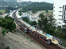
<span class="mw-page-title-main">Ma On Shan line</span> Former Hong Kong railway line

The Ma On Shan line was a rapid transit line that formed part of the Mass Transit Railway (MTR) system in Hong Kong. Coloured brown on the MTR map, the line acted as a branch of the East Rail line that connects the new towns of Sha Tin and Ma On Shan in the northeastern New Territories.

<span class="mw-page-title-main">Sheung Shui</span> Area of Hong Kong

Sheung Shui is an area in the New Territories, Hong Kong. Sheung Shui Town, a part of this area, is part of the Fanling–Sheung Shui New Town in the North District of Hong Kong. Fanling Town is to its southeast.

<span class="mw-page-title-main">Sha Tin</span> Neighbourhood in New Territories, Hong Kong, China

Sha Tin, also spelt Shatin, is a neighbourhood along Shing Mun River in the eastern New Territories, Hong Kong. Administratively, it is part of the Sha Tin District. Sha Tin is one of the neighbourhoods of the Sha Tin New Town project.

<span class="mw-page-title-main">Tuen Mun</span> Area in the New Territories, Hong Kong

Tuen Mun or Castle Peak is an area near the mouth of Tuen Mun River and Castle Peak Bay in the New Territories, Hong Kong. It was one of the earliest settlements in what is now Hong Kong and can be dated to the Neolithic period. In the more recent past, it was home to many Tanka fishermen who gathered at Castle Peak Bay. Tuen Mun is now a modern, mainly residential area in the north-west New Territories. As of 2011, 487,546 live in Tuen Mun and over 95% of them are Chinese.

<span class="mw-page-title-main">Wu Kai Sha</span>

Wu Kai Sha, formerly known as Wu Kwai Sha or U Kwai Sha, is a place at the shore of Tolo Harbour, northwest of Ma On Shan in the New Territories, Hong Kong. Wu Kai Sha is within the Sha Tin District, one of the 18 districts of Hong Kong. The name roughly translates as Black Sand Creek, based on the accumulation of black iron ore which traditionally flowed down from the Ma On Shan (peak).

<span class="mw-page-title-main">Ma On Shan (town)</span>

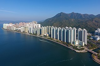
Ma On Shan is a new town along the eastern coast of Tolo Harbour in the New Territories of Hong Kong. Although it was initially an extension of Sha Tin New Town, it has its own town centre and various government facilities, and is now classified as a separate new town in government reports. Administratively, it belongs to Sha Tin District.

<span class="mw-page-title-main">Tin Shui Wai</span> Place in New Territories, Hong Kong

Tin Shui Wai New Town is a satellite town in the northwestern New Territories of Hong Kong. Originally a gei wai (基圍) fish pond area, it was developed in the 1980s as the second new town in Yuen Long District and the eighth in Hong Kong. It is 25 kilometres (16 mi) due northwest of Central, the main business area in the territory, on land reclaimed from low-lying areas south of Deep Bay, next to historic Ping Shan. The population was 292,000 in 2014, while the total projected population for when the town is fully built-out is about 306,000.

Articles related to Hong Kong include:

<span class="mw-page-title-main">Wong Shek Pier</span>

Wong Shek Pier is a public pier on the shore of Long Harbour (赤徑海) in the north-east of Hong Kong's New Territories. It is situated in the Wong Shek (黃石) area of the Sai Kung Peninsula. Administratively it is in Tai Po District.
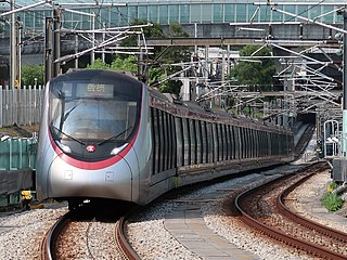
<span class="mw-page-title-main">Tuen Ma line</span> Hong Kong MTR railway line

The Tuen Ma lineis a rapid transit line that forms part of the Mass Transit Railway (MTR) system in Hong Kong. Coloured brown on the map, the Tuen Ma line is 56.2 kilometres (34.9 mi) in length, making it the longest line of the MTR network. It has a total of 27 stations, more than any other in the MTR system.

<span class="mw-page-title-main">Fortune City One</span> Shopping mall

Fortune City One is one of the two shopping centres of City One, Sha Tin, New Territories, Hong Kong. It is owned by Cheung Kong Holdings. It is connected to nearly apartments and another shopping centre in City One, Fortune City One Plus, just across the street, by bridges.

<span class="mw-page-title-main">Mountain Shore</span> Private housing estate in Hong Kong

Mountain Shore is a full market value development in Tai Shui Hang, Ma On Shan, Sha Tin District, New Territories, Hong Kong. The estate is one of the Hong Kong Housing Society's Sandwich Class Housing Scheme projects converted into private developments.

<span class="mw-page-title-main">Public housing estates in Ma On Shan</span>

The following is a list of Public housing estates in Ma On Shan, Hong Kong, including Home Ownership Scheme (HOS), Private Sector Participation Scheme (PSPS), Sandwich Class Housing Scheme (SCHS), Flat-for-Sale Scheme (FFSS), and Tenants Purchase Scheme (TPS) estates.

<span class="mw-page-title-main">Chevalier Garden</span> Public housing estate in Ma On Shan, Hong Kong

Chevalier Garden is a Home Ownership Scheme and Private Sector Participation Scheme court in Tai Shui Hang, Ma On Shan, New Territories, Hong Kong near MTR Tai Shui Hang station. It was jointly developed by the Hong Kong Housing Authority and Chevalier Group, and it was the first HOS court developed by Chevalier Group. It has a total of seventeen blocks built between 1987 and 1988.

<span class="mw-page-title-main">Yan On Estate</span> Public housing estate in Ma On Shan, Hong Kong

Yan On Estate is a public housing estate in Ma On Shan, New Territories, Hong Kong located south of Heng On Estate. The HK$800 million construction contract was awarded by the Housing Authority to Yau Lee Construction in 2009. The new estate opened in 2011 and comprises three blocks and a small commercial centre. It is designed to house about 6,800 residents in 2,587 flats. The estate is within walking distance of Heng On station on the Tuen Ma line.

<span class="mw-page-title-main">Tai Shui Hang Village</span>

Tai Shui Hang Village is a historic village within the Tai Shui Hang area, in Ma On Shan, Sha Tin District, New Territories, Hong Kong.

References

  1. "Brief History". www.ccc.cuhk.edu.hk. Retrieved 9 February 2020.
  2. "Greene, Geoffrey Philip, (1868–19 May 1930), General Manager Ceylon Government Railway, 1901; retired, 1923", Who Was Who, Oxford University Press, 1 December 2007, doi:10.1093/ww/9780199540884.013.u210386
  3. "www.emsd.gov.hk" (PDF).
  4. 1 2 "Yucca de Lac, Ma Liu Shui, Shatin | Gwulo: Old Hong Kong". gwulo.com. Retrieved 9 February 2020.
  5. 1 2 "Seven years, HK$1b put 21 houses on Tai Po's Yucca de Lac restaurant site". South China Morning Post. Retrieved 9 February 2020.
  6. "Hong Kong UNESCO Global Geopark". www.geopark.gov.hk. Retrieved 9 February 2020.
  7. "POA School Net 91" (PDF). Education Bureau . Retrieved 9 October 2022.
  8. "Ma Liu Shui ferry services". www.info.gov.hk. Retrieved 9 February 2020.
  9. "www.traway.com.hk". Archived from the original on 7 February 2009. Retrieved 9 February 2020.

22°24′59″N114°12′32″E / 22.41639°N 114.20889°E / 22.41639; 114.20889