| Sham Tseng | |||||||||||||
|---|---|---|---|---|---|---|---|---|---|---|---|---|---|
| Chinese | 深井 | ||||||||||||
| Literal meaning | Deep well | ||||||||||||
| |||||||||||||


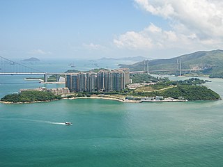
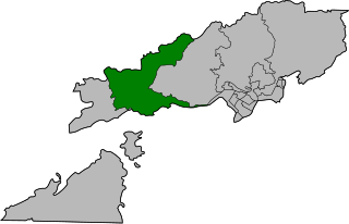
Sham Tseng is a coastal area in Tsuen Wan District,Hong Kong,between Ting Kau and Tsing Lung Tau.
| Sham Tseng | |||||||||||||
|---|---|---|---|---|---|---|---|---|---|---|---|---|---|
| Chinese | 深井 | ||||||||||||
| Literal meaning | Deep well | ||||||||||||
| |||||||||||||


Sham Tseng is a coastal area in Tsuen Wan District,Hong Kong,between Ting Kau and Tsing Lung Tau.
At the time of the 1911 census,the population of Sham Tseng was 72. The number of males was 32. [1]
In 1982,the Government launched a new town project for the area. There were proposals for a massive housing scheme,where the population of the village,then estimated at 6,000,was set to increase dramatically to 50,000 people. There would be an additional 26,000 in public housing,Home Ownership Scheme flats,Government offices and other amenities constructed on 47 hectares of land. [2]
Starting in the 1990s,more and more private housing estates were built in the area for its views of Tsing Ma Bridge over Ma Wan Channel. It is linked to many other parts of Hong Kong by buses and mini-buses.
Sham Tseng's villages are overshadowed and towered by new private housing estates:
Sham Tseng Resite Village is a recognized village under the New Territories Small House Policy. [3]
Sham Tseng is also home to the Sham Tseng Light Housing project,a 45-unit temporary social housing project housed in a former textile factory building. [5]
There are three schools in Sham Tseng:
Sham Tseng is in Primary One Admission (POA) School Net 62,which includes schools in Tsuen Wan and areas nearby. The net includes multiple aided schools and one government school,Hoi Pa Street Government Primary School. [8]

Sham Tseng is home to baker Garden Company Limited and former home of San Miguel Brewery Hong Kong. The brewery operations began in the 1933 as Hong Kong Brewers and Distillers Ltd under JH Ruttonjee and was sold to San Miguel Corporation in 1948. [9] The brewery operations and head office moved in 1996 to Yuen Long Industrial Estate. [10] A private housing estate called Bellagio now occupies the site of the old brewery. [4]
Union Carbide once had a storage depot in the area,but it has since moved. [4]
Small family restaurants make the bulk of the employment in the area. Most area residents work outside of Sham Tseng.

To the north of Sham Tseng is an undeveloped hilly area. Tai Lam Country Park,a large park located northwest of Sham Tseng. There are nature trails along Butterfly River and Falls near Sham Tseng.
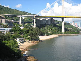
Numerous beaches are found at or near Sham Tseng from the waterways joining Ma Wan Channel and Rambler Channel,but most are so polluted and officially closed from swimming due to contamination from sewers and the Sham Tseng Nullah. [11] As a consequence,residents are more inclined to swim in pools located at their residential complexes.
A list of beaches in Sham Tseng:
Sham Tseng Temporary Market is a local produce market under the Sham Tseng Bridge flyover.
There are two retail malls located below residential flats to meet local needs:
Sham Tseng is famous for roasted goose [12] and they can be found at various restaurants in the area:
Major roads in Sham Tseng include:
Local roads include:
Hong Kong has a long and jagged coastline with many bays and beaches. The shelter provided by adjacent mountains keeps wave sizes generally small,and most beaches are thus suitable for swimming and recreation,if they can be reached.

Tsing Yi,sometimes referred to as Tsing Yi Island,is an island in the New Territories of Hong Kong,to the northwest of Hong Kong Island and south of Tsuen Wan. With an area of 10.69 km2 (4.13 sq mi),the island has been extended drastically by reclamation along almost all its natural shore and the annexation of Nga Ying Chau (牙鷹洲) and Chau Tsai. Three major bays or harbours,Tsing Yi Lagoon,Mun Tsai Tong,and Tsing Yi Bay (青衣灣) in the northeast,have been completely reclaimed for new towns.

Cheung Sha is a rural area on the south coast of Lantau Island,New Territories,Hong Kong. Along the South Lantau Road,Cheung Sha is located between Tong Fuk and San Shek Wan.

Ma Wan is an island of Hong Kong,located between Lantau Island and Tsing Yi Island,with an area of 0.97 square kilometres. Administratively,it is part of Tsuen Wan District.

Ma Wan Tung Wan Beach is a gazetted beach near Noah's Ark on Ma Wan island,Hong Kong. The beach is managed by the Leisure and Cultural Services Department of the Hong Kong Government. The beach is 140 metres long and is rated as Grade 4 by the Environmental Protection Department for its water quality. It is the only gazetted beach in Ma Wan and offers views of Ting Kau Bridge as well as Tsing Ma Bridge.

Tuen Mun Road is a major expressway in Hong Kong which connects Tuen Mun with Tsuen Wan,within the New Territories. It is part of Hong Kong's Route 9,which circumnavigates the New Territories. Opened in 1978,it was once the major trunk route linking the northwest New Territories to urban Kowloon and is known for its frequent traffic jams and road accidents owing to its early design and heavy usage. As a result,speed limits have been enforced to 70–80 km/h (45–50 mph) due to geometric constraints.

Ma Wan Channel is a channel between Ma Wan and Tsing Yi islands in Hong Kong. The north end of the channel is Ting Kau where it joins the Rambler Channel. To the west it joins with the Kap Shui Mun channel running to the south of Ma Wan,leading into Urmston Road. To the east,it divides into the Tsing Yi Channel and the Rambler Channel,leading to Tsuen Wan and Kwai Chung. To the south is the Western Working Anchorage of Victoria Harbour.
Castle Peak Road is the longest road in Hong Kong. Completed in 1920,it has the approximate shape of an arc of a semi-circle. It runs west from Tai Po Road in Sham Shui Po,New Kowloon,to Tuen Mun,then north to Yuen Long and east to Sheung Shui,in the very north of the New Territories;it is divided into 22 sections.

Ting Kau is an area in west Tsuen Wan District,New Territories,Hong Kong. Ting Kau Village is a village near the shore. Ting Kau is famous for the Ting Kau Bridge,spanning the Rambler Channel,from Ting Kau to Tsing Yi Island.
Tsuen Wan Rural Committee (荃灣鄉事委員會) is a rural committee representing the interest of villages in Tsuen Wan and Kwai Chung,Hong Kong.

Tsing Lung Tau is a coastal residential area in the southwest coast of the New Territories in Hong Kong.

Tsing Chau Tsai Peninsula is the peninsula located at the northeast of Lantau Island,New Territories,Hong Kong,including Yam O,To Kau Wan,Tai Tsing Chau,Tsing Chau Tsai and Penny's Bay.

The Tuen Mun Rural Committee is a rural committee in Hong Kong. It was founded by rural leader Chan Yat-sen in 1953 with representatives from 29 villages in Tuen Mun. Today the rural committee consisted of 36 villages and 69 village representatives.

Ting Sham is one of the 18 constituencies in the Tsuen Wan District of Hong Kong which was created in 2015.

Lido Beach is located on Castle Peak Road in Ting Kau,New Territories,Hong Kong. It is a gazetted beach,meaning it is managed by the Leisure and Cultural Services Department,which provides lifeguards during the summer months.

Ting Kau Beach is a gazetted beach located at the northwest end of Victoria Harbour on Castle Peak Road in Ting Kau,New Territories,Hong Kong. The beach is managed by the Leisure and Cultural Services Department of the Hong Kong Government. The beach is rated as Grade 2 by the Environmental Protection Department for its water quality.

Hoi Mei Wan Beach is a gazetted beach located near Airport Core Programme Exhibition Centre on Castle Peak Road in Ting Kau,New Territories,Hong Kong. The beach has barbecue pits and is managed by the Leisure and Cultural Services Department of the Hong Kong Government. The beach is rated as Grade 2 by the Environmental Protection Department for its water quality. The beach offers views of the Ting Kau Bridge as well as Tsing Ma Bridge.

Approach Beach is a gazetted beach located near Yau Kom Tau on Castle Peak Road in Ting Kau,New Territories,Hong Kong. The beach has barbecue pits and is managed by the Leisure and Cultural Services Department of the Hong Kong Government. The beach is rated as Grade 2 by the Environmental Protection Department for its water quality.