Suppose the area is divided by the Island Eastern Corridor,the seaside side of the new reclamation area to the north of the corridor area are private estates such as Grand Promenade,Les Saisons and Lei King Wan,the other side of the corridor area is dominated by old buildings,that is,it is built along the main road Shau Kei Wan Road. New private residences are also completed in the area,such as THE HOLBORN,which is completed in 2023 and Island Residence which is completed in 2017.
Sai Wan Ho is conventionally agreed to extend between the Taikoo Shing Road,Shau Kei Wan Road and King's Road junction to the west,and the Shau Kei Wan tram depot in the east. It is bounded by the Victoria Harbour to the north,and mountains to the south.
History
Early development
The Xin'an County Chronicle published in the 24th year of Jiaqing in the Qing Dynasty (1819) did not have any records about Sai Wan Ho.
According to relevant information,Sai Wan Ho had 420 residents in 1901,and there were markets and slaughterhouses. The outer wall of the market is made of red bricks,and it is divided into two parts,the inside and the outside. There is a tea stall outside,which is located in the current Sai Wan Ho Civic Center. There are also several shops on the sidewalk outside the market,including a noodle shop and a cotton tire shop.
Later,Sai Wan Ho used to be the dormitory of Taikoo Dockyard which accommodated more than 10,000 people at the beginning of the last century. It was completed in 1909. It was divided into 1st,2nd,and 3rd Streets,which is the current Tai On Building. The building is 4 floors high,and each unit is divided into There are 4 to 5 married staff rooms,with 3 to 4 3-bunk beds outside the rooms,which are provided for single staff in the dock. The toilet and kitchen are shared by the whole unit,and the stove is wood-burning,which can accommodate more than 10,000 people.
At the time of the 1911 census,the population of Sai Wan Ho was 876. The number of males was 650.[1]
Post-war development
In the 1960s,Shau Kei Wan and Sai Wan Ho were developed together. First,build Taixiang/Taishun/Taifu/Taikang four 11-story buildings behind Liwan Building,each floor has 18 units of dormitories,which are used to accommodate the employees of 1st,2nd,and 3rd Streets to relocate to new dormitories. Because Taikoo Dockyard has its own pond,the running water in the dormitory is provided by the shipping company for free. Developed by Swire and completed in 1968,Tai On Building,located by the sea at that time,once became a local landmark.
The Tai On Building Building is an H-shaped building with a height of 28 floors. The basement is a large shopping mall,a gas station and a theatre (a small factory is in the middle),a parking space outside the factory,and a water station for fishing boats (at that time too The outside of Anlou is already the seaside). There are fresh fish,butcher shops,grocery stores,and grocery stores in the shopping mall. There is also a restaurant on the side of the tramway. There is a public telephone near the underground elevator for the convenience of residents. The platform facing the sea on the first floor is a public resting garden.
Residential development
Until 1979,Tai On Building was still located by the sea. However,in the 1980s,due to the multiple relocations of the Shau Kei Wan Pier and the construction of the Island Eastern Corridor,the waterfront of Sai Wan Ho continued to move northward. Up to now,the entire area of Lei King Wan has been reclaimed from the sea.
Going up from Cheng'an Street,before the 1980s,it was a wooden house area,including Cheng'an Village,Holy Cross Path Village,Auberong Village,etc. But in 1989,the government acquired the land and built public housing estates –Yiu Tung Estate and Hing Tung Estate.
Current
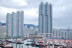
Sai Wan Ho is one of the predominantly residential areas in East Hong Kong Island. The new reclamation area to the north of the Eastern Corridor belongs to the high-end private housing estate residential area. The three major housing estates:Grand Promenade,Les Saisons and Lei King Wan are located on the seaside side of the corridor area. The waterfront of Sai Wan Ho is known as Soho East,and there are authentic Soho East restaurants,theme bars and speciality coffee shops gathered along the waterfront,forming a good place for dining and drinking.
On the other side of the corridor area,there are many flats under Home Ownership Scheme and a small number of public housing estates,such as Tung Hei Court,Tung Yan Court,Tung Lam Court,Tung Tao Court,Hing Tung Estate and Hong Tung Estate. There are also new private housing estates being completed in the area,such as THE HOLBORN,which is expected to be occupied in 2023,and Island Residence,which is expected to be completed in 2017.
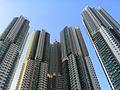
Sai Wan Ho is primarily residential. The hill was once filled with squatter settlements,which were later demolished and replaced with new residential buildings. Taikoo Shing,redeveloped from Taikoo Dockyard,spans the east end of the area. From the 1980s through the 2000s,extensive reclamation drastically reshaped the shore. Private housing estates were built near the new sea front,like Lei King Wan,Les Saisons and Grand Promenade. However,older buildings such as Tai On Building still remain further inland.
Sai Wan Ho is well-planned and there are many green spaces and recreational facilities in the area,especially along the waterfront,such as Aldrich Bay Park,Aldrich Bay Seaside Garden,Sai Wan Ho Waterfront Park,Quarry Bay Park,etc.
Sai Wan Ho is home to a number of prestigious institutions,international schools,and special education. Sai Wan Ho is in Primary One Admission (POA) School Net 16. Within the school net are multiple aided schools (operated independently but funded with government money) and two government schools:Shau Kei Wan Government Primary School and Aldrich Bay Government Primary School.[2]
Korean International School of Hong Kong,International school (primary (reception to year 6) for ages 4–11,secondary (year 7–13) for ages 12–18,and Springboard (SEN) for ages 6–18)
The International Montessori School,International school
Island Children's Montessori Kindergarten (Lei King Wan),International school
Grace Garden International Kindergarten (Lei King Wan),International school
Baptist Pui Li School,local kindergarten
Dominic Savio Kindergarten,local kindergarten
HKFYG Ching Lok Kindergarten,local kindergarten
Caritas Lok Yi School,special education school
Transport
Sai Wan Ho has convenient transportation to and from various districts in Hong Kong,Kowloon and New Territories. Sai Wan Ho is about a 10-minute walk from the adjacent shopping malls Cityplaza and Taikoo Place business areas. The Island Line runs through Sai Wan Ho Station and shuttles to the north shore of Hong Kong Island. It takes 12 and 18 minutes for Sai Wan Ho to Causeway Bay and Central respectively.
In terms of buses,there are many bus routes on Shau Kei Wan Road between Hong Kong,Kowloon and the New Territories,many of which use Sai Wan Ho Grand Promenade as the terminus. Hong Kong Tramways run along Shau Kei Wan Road,providing a cheaper option for travelling across Hong Kong Island.
This page is based on this Wikipedia article Text is available under the CC BY-SA 4.0 license; additional terms may apply. Images, videos and audio are available under their respective licenses.