| Tai Mei Tuk | |||||||||
|---|---|---|---|---|---|---|---|---|---|
| Official name | |||||||||
| Traditional Chinese | 大美督 | ||||||||
| |||||||||
| Also written as: | |||||||||
| Traditional Chinese | 大美篤 大尾篤 大尾督 大美篤 | ||||||||
| |||||||||


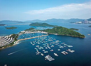
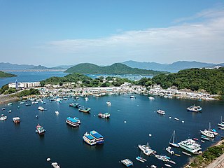
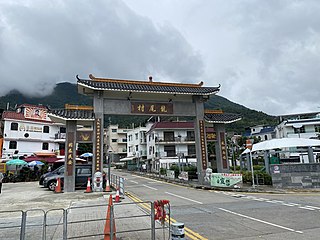
Tai Mei Tuk is a place close to the Plover Cove Reservoir in the Tai Po District,New Territories,Hong Kong.

| Tai Mei Tuk | |||||||||
|---|---|---|---|---|---|---|---|---|---|
| Official name | |||||||||
| Traditional Chinese | 大美督 | ||||||||
| |||||||||
| Also written as: | |||||||||
| Traditional Chinese | 大美篤 大尾篤 大尾督 大美篤 | ||||||||
| |||||||||


Tai Mei Tuk is a place close to the Plover Cove Reservoir in the Tai Po District,New Territories,Hong Kong.
Tai Mei Tuk is a recognized village under the New Territories Small House Policy. [1] It is one of the villages represented within the Tai Po Rural Committee. For electoral purposes,Tai Mei Tuk is part of the Shuen Wan constituency,which was formerly represented by So Tat-leung until October 2021. [2] [3]
Historically,Ting Kok,together with the nearby Hakka villages of Shan Liu,Lai Pik Shan,Lo Tsz Tin,Lung Mei and Tai Mei Tuk belonged to the Ting Kok Yeuk (汀角約) alliance. [4]
Tai Mei Tuk means "the very end" in the Cantonese language which depicts the landscape. The homonym character 篤 (tuk) is borrowed for the name. Recent Cantonese research suggested that the correct character is 䐁.[ citation needed ]
Tai Mei Tuk is a popular place for barbecues and cycling. There are villages and a harbour nearby,where many restaurants can be found. Bicycles are also available for hire in the villages.
The Tai Mei Tuk Sea Activity Centre of the Scout Association of Hong Kong is located in the area and also provides sea Scouting activities in Hong Kong.
The Hong Kong Government has holiday bungalows for government employees at Tai Mei Tuk. [5]

Tai Po District is one of the 18 districts of Hong Kong. The suburban district covers the areas of Tai Po New Town,Tai Po Tau,Tai Po Kau,Hong Lok Yuen,Ting Kok,Plover Cove,Lam Tsuen Valley,Tai Mei Tuk and other surrounding areas,and its exclaves Sai Kung North,in the northern part of the Sai Kung Peninsula and including islands such as Grass Island,and Ping Chau. Tai Po proper and Sai Kung North are divided by the Tolo Channel and the Tolo Harbour. The district is located in the Eastern New Territories. The de facto administrative centre of the district is Tai Po New Town.

Plover Cove Reservoir,located within Plover Cove Country Park,in the northeastern New Territories,is the largest reservoir in Hong Kong in terms of area,and the second-largest in terms of volume. It is the world's first freshwater coastal lake constructed from an arm of the ocean. Its main dam,which disconnected Plover Cove from the sea,was one of the largest in the world at the time of its construction.

Plover Cove also known for its Chinese names Shuen Wan Hoi or Shuen Wan (船灣),is a cove in the Tai Po District of Hong Kong,near Tolo Channel and Tolo Harbour.

Tung Tsz,sometimes transliterated as Tung Tsai,is an area near Shuen Wan in the Tai Po District of the New Territories,Hong Kong,under the hills of Pat Sin Leng. The area is mainly rural and has a few villages. The campus of The Education University of Hong Kong and the campsite of Tung Tsz Scout Centre for The Scout Association of Hong Kong are also located in the area.

Plover Cove Country Park is a country park in Hong Kong located in the Northeastern New Territories. The original country park was established on 7 April 1978,covering 4,594 hectares of natural terrain in the administrative North District and Tai Po District. A northern extension to the park,Plover Cove (Extension) Country Park,was designated on 1 June 1979,covering the Double Haven islets and Ping Chau.

Tai Po New Town,or Tai Po Town,is a new town and non-administrative area in Tai Po District,in the New Territories,Hong Kong. The area is a planned town that surrounding the existing indigenous market towns Tai Po Hui and Tai Po Kau Hui,as well as east of the existing indigenous villages that located on the Lam Tsuen Valley as well as west of those villages in Ting Kok and Tai Mei Tuk and south of those villages in Nam Hang,Fung Yuen and Sha Lo Tung. Most of the lands of the new town were obtained by land reclamation. In present day,Tai Po New Town was simply known as Tai Po. The new town are largely covered by the government Tai Po Outline Zoning Plan,which legally regulated the land use of the area,on top of the terms in the land lease contract with the government. Some of the land lease within the area,were known as Tai Po Town Lot №foo. In election,the town had a different zoning scheme for the election constituencies.

Yim Tin Tsai is an island of Hong Kong located in Tolo Harbour.

Sam Mun Tsai is an area and a village in Yim Tin Tsai,Tai Po District,Hong Kong.

Ting Kok is the name of an area and a village in the northeastern part of Hong Kong. It is located on the northern shore of Plover Cove and west of Tai Mei Tuk. Administratively,it is part of Tai Po District.

Po Sam Pai is a village in Plover Cove,Tai Po District,Hong Kong.

Shuen Wan Chan Uk is a village in Tai Po District,Hong Kong.

Shuen Wan Chim Uk is a village in Tai Po District,Hong Kong.

Shuen Wan Lei Uk is a village in Tai Po District,Hong Kong.
Wai Ha or Shuen Wan Wai Ha ({zh|t=船灣圍下|Labels=no}}) is a village in Tai Po District,Hong Kong.

San Tau Kok is a village in Tai Po District,Hong Kong.
Lo Tsz Tin is a village in Tai Po District,Hong Kong.

Lung Mei is a village in the Plover Cove area of Tai Po District,Hong Kong. It is located on the northern shore of Plover Cove in the west of Tai Mei Tuk.
Shan Liu is a village in the Plover Cove area of Tai Po District,Hong Kong.
Coordinates: 22°28′13″N114°13′58″E / 22.4703°N 114.2329°E