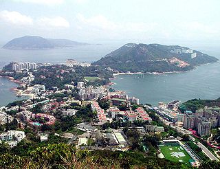
Stanley, or Chek Chue, is a coastal town and a popular tourist attraction in Hong Kong. It is located on a peninsula on Hong Kong Island. It is east of Repulse Bay and west of Shek O, adjacent to Chung Hom Kok and Tai Tam. Administratively, it is part of the Southern District.

Tai Po District is one of the 18 districts of Hong Kong. The suburban district covers the areas of Tai Po New Town, Tai Po Tau, Tai Po Kau, Hong Lok Yuen, Ting Kok, Plover Cove, Lam Tsuen Valley, Tai Mei Tuk and other surrounding areas, and its exclaves Sai Kung North, in the northern part of the Sai Kung Peninsula and including islands such as Grass Island, and Ping Chau. Tai Po proper and Sai Kung North are divided by the Tolo Channel and the Tolo Harbour. The district is located in the Eastern New Territories. The de facto administrative centre of the district is Tai Po New Town.

Most of the walled villages of Hong Kong are located in the New Territories.

Ma On Shan Country Park is a park located in the central neck of the Sai Kung Peninsula in the eastern New Territories of Hong Kong. The park covers an area of 28.8 square kilometres (11.1 sq mi) and links Sai Kung Country Park and Lion Rock Country Park to form an extensive recreation area on the Ma On Shan massif.

San Po Kong is an area in New Kowloon in Hong Kong. It is largely industrial and partly residential. Administratively, it belongs to Wong Tai Sin District.

Tsz Wan Shan is a residential area in Kowloon, Hong Kong. Located below Temple Hill, it is administratively part of Wong Tai Sin District. Temple Hill is also called Tsz Wan Shan 慈雲山, but Tsz Wan Shan usually refers to the area.
Tai Wai is an area in the New Territories, Hong Kong, located between Sha Tin and the Lion Rock, within the Sha Tin District.

The Wilson Trail is a 78-kilometre (48 mi) long-distance footpath in Hong Kong, 63 km of which runs through Hong Kong country parks. It was named after David Wilson, Baron Wilson of Tillyorn, who was Governor of Hong Kong from 1987 to 1992. The Wilson Trail was developed by Friends of the Country Park and sponsored by various private organisations. The construction work of the trail began in 1994. The Wilson Trail was first opened on 21 January 1996.

Lion Rock Country Park is a country park, located in the New Territories, Hong Kong. It consists of approximately 5.57 square kilometres (2.15 sq mi) of land, including Lion Rock and Mong Fu Shek and their surrounding scenic hillsides, of which 3.48 square kilometres (1.34 sq mi) is forestry plantation.

Grassy Hill is the fourteenth highest mountain in Hong Kong. Peaked at 647 m (2,123 ft), it is situated between Tsuen Wan and Tai Po and near Lead Mine Pass. Stage 7 of MacLehose Trail runs near its peak.
Tai Po Road is the second longest road in Hong Kong. It spans from Sham Shui Po in Kowloon to Tai Po in the New Territories of Hong Kong. Initially, the road was named Frontier Road.

Violet Hill, also known as Tsz Lo Lan Shan, is located within Tai Tam Country Park in Hong Kong. The hill is a popular site for hiking. The Hong Kong Government named three trails on the hill, namely Wilson Trail, Tsz Lo Lan Shan Path and Tai Tam Country Trail. Towards the top of the hill, it splits into three peaks of altitude 436 m (1,430 ft), 433 m (1,421 ft) and 430 m (1,410 ft) respectively. It offers views of the group of Tai Tam Reservoirs and Wong Nai Chung Reservoir. The hill is well preserved, with little construction on the hill. A rare and protected species, Hong Kong iris with violet flower can be found on the hill.

Tai Ping Shan Street is a street marking the early colonial history in Hong Kong. Located at the north slope of Victoria Peak in Sheung Wan, the street starts east from a ladder street at the junction with Bridges Street and end west in Po Yan Street near Tung Wah Hospital. The street runs parallel to Hollywood Road.
Crow's Nest is a hill north of So Uk in Cheung Sha Wan of New Kowloon in Hong Kong. It has a height of 194 metres and is located south of Eagle's Nest. It is one of the Eight Mountains of Kowloon.

Anderson Road is a road on the eastern border of the New Territories and New Kowloon in Hong Kong. It starts near the junction of Clear Water Bay Road and New Clear Water Bay Road, above Shun Lee Estate, then continues southeast to Tseng Lan Shue (井欄樹) and eastward through the hills above Sau Mau Ping, and finally ends at Po Lam Road (寶琳路) in Ma Yau Tong.
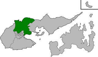
Hong Lok Yuen is one of the 19 constituencies in the Tai Po District.

Black Hill is a hill in Hong Kong with a height of 304 metres. It is located between the communities of Lam Tin, Kowloon and Tiu Keng Leng, Sai Kung.

The Twins, also officially known as Ma Kong Shan, are a pair of mountains in southern Hong Kong. They are a popular destination for hikers and fitness enthusiasts as part of the rigorous Violet Hill-The Twins Hike on Hong Kong Island. Hiking up The Twins involves walking up a long steep set of stairs featuring more than 1000 steps straight up.

Wa Mei Shan is a mountain in northeastern Hong Kong on Sai Kung Peninsula. It is located within Tai Po District.

