
Hong Kong has a highly developed and sophisticated transport network, encompassing both public and private transport. Based on Hong Kong Government's Travel Characteristics Survey, over 90% of the daily journeys are on public transport, the highest rate in the world. However, in 2014 the Transport Advisory Committee, which advises the Government on transportation issues, issued a report on the much worsened congestion problem in Hong Kong and pointed at the excessive growth of private cars during the past 10–15 years.

The Islands District is one of the 18 districts of Hong Kong. It is part of the New Territories. It had a population of 170,900 in 2018.
Hong Kong has a long coastline that is full of twists and turns with many bays and beaches. Many of them are well sheltered by mountains nearby, as Hong Kong is a mountainous place. As a result, large waves seldom appear at the bays, making them suitable for human swimming.

Sha Tin District is one of the 18 districts of Hong Kong. As one of the 9 districts located in the New Territories, it covers the areas of Sha Tin, Tai Wai, Ma On Shan, Fo Tan, Siu Lek Yuen, Kwun Yam Shan and Ma Liu Shui. The district is the most populous district in Hong Kong, with a population of 659,794 as per 2016 by-census, having a larger population than many states or dependencies including Iceland, Malta, Montenegro and Brunei.

Sai Kung District is one of the 18 districts of Hong Kong, a special administrative region of China. The district comprises the southern half of the Sai Kung Peninsula, the Clear Water Bay Peninsula in the New Territories and a strip of land to the east of Kowloon. Areas in the district include Sai Kung Town, Hong Kong UNESCO Global Geopark, Tseung Kwan O and over 70 islands of different sizes. The administrative centre had been located in Sai Kung Town until the Sai Kung District Office was relocated to Tseung Kwan O recently. The district's population is concentrated in Tseung Kwan O, as of 2011. In 2011, the district was the third youngest district, with a median age of 39.3. Known as the "back garden of Hong Kong", Sai Kung has been able to retain its natural scenery. Many traditional customs and cultures are still retained in the rural villages.
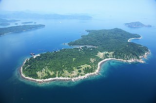
Grass Island or Tap Mun is an island in Hong Kong, located in the northeastern part of the territory. Its area is 1.69 km2 (0.65 sq mi). Administratively, it is part of the Tai Po District. There are about 100 people living on the island, and feral cattle are known on the island.

The Sai Kung Peninsula is a peninsula in the easternmost part of the New Territories in Hong Kong. Its name comes from Sai Kung Town in the central southern area of the peninsula. The southern part of the peninsula is administrated by Sai Kung District, the north by Tai Po District and the northwest by Sha Tin District.

The kai-to, sometimes kaito or kaido is a type of small, motorised ferry that operates in Hong Kong. They are usually used to serve remote coastal settlements in the territory's outlying islands.

The MacLehose Trail is a 100-kilometre hiking trail that crosses much of the New Territories, Hong Kong, starting from Pak Tam Chung, Sai Kung District in the east to Tuen Mun Town, Tuen Mun District in the west. The path is marked by distance posts at 500-metre intervals. The trail is named after Murray MacLehose, Baron MacLehose of Beoch, the longest-serving governor of Hong Kong, who established the Country Parks and was himself an enthusiastic hiker. The trail passes through a variety of natural scenery including beaches and mountains.

Long Harbour, also known as Tai Tan Hoi, is a natural harbour formed from an inlet of Mirs Bay to the north of Sai Kung Peninsula, Hong Kong.

Pak Tam Chung is an area in the southern part of the Sai Kung Peninsula in the New Territories of Hong Kong. It is administratively under the Sai Kung District.
The Outlying Islands are all the islands that make up the territory of Hong Kong, with the exception of Hong Kong Island and some smaller islands near its coast. There are 263 islands over 500 m2 in Hong Kong, the vast majority of which are located within the New Territories, with significant numbers located in Islands District in the south and southwest, Sai Kung District in the southeast, and Tai Po District and North District in the northeast. The term "outlying" is not strictly defined and in some cases islands very close to Hong Kong Island and mainland China are not included.
Articles related to Hong Kong include:

Wong Shek Pier is a public pier on the shore of Long Harbour (赤徑海) in the north-east of Hong Kong's New Territories. It is situated in the Wong Shek (黃石) area of the Sai Kung Peninsula. Administratively it is in Tai Po District.
Cyclists in Hong Kong have the same rights and responsibilities as all other road users, except for prohibitions from expressways and some other designated locations, such as all tunnel areas, the Tsing Ma and Tsing Sha control areas, many elevated roads and many underpasses. At least one hand must be kept on the handlebars at all times. Cyclists must use a cycle track wherever one is present.

Lai Chi Chong is a village and an area of Hong Kong, located on the southeastern shore of Tolo Channel, and on the northern shore of the Sai Kung Peninsula, in the Eastern New Territories. Administratively, it is part of Tai Po District.

Sham Chung is a Hakka village and an area of Neolithic settlement in Hong Kong. It is located in the south of Tolo Channel, beside Three Fathoms Cove on the Sai Kung Peninsula. Administratively, it is part of Tai Po District.
Sai Kung North refers collectively to the areas on the southern side of Tolo Harbour and the northernmost part of the Sai Kung Peninsula. Part of this broad area is served by Sai Sha Road, a motorway between Sai Kung and Ma On Shan.


