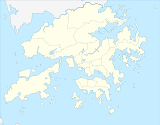
The geography of Hong Kong primarily consists of three main territories: Hong Kong Island, Kowloon Peninsula, and the New Territories.
The Eastern District is one of the 18 districts of Hong Kong. It had a population of 588,094 in 2011. The district has the second highest population while its residents have the third highest median household income among 18 districts.

Hong Kong Island is an island in the southern part of Hong Kong. It has a population of 1,289,500 and its population density is 16,390/km², as of 2008. The island had a population of about 3,000 inhabitants scattered in a dozen fishing villages when it was occupied by the United Kingdom in the First Opium War. In 1842, the island was formally ceded in perpetuity to the UK under the Treaty of Nanking and the City of Victoria was then established on the island by the British Force in honour of Queen Victoria.

Lantau Island is the largest island in Hong Kong, located at the mouth of the Pearl River. Administratively, most of Lantau Island is part of the Islands District of Hong Kong. A small northeastern portion of the island is located in the Tsuen Wan District.

Kowloon is an urban area in Hong Kong comprising the Kowloon Peninsula and New Kowloon. It is bordered by the Lei Yue Mun strait to the east, Mei Foo Sun Chuen and Stonecutter's Island to the west, a mountain range, including Tate's Cairn and Lion Rock to the north, and Victoria Harbour to the south. With a population of 2,019,533 and a population density of 43,033/km2 in 2006, it is the most populous urban area in Hong Kong. The peninsula's area is approximately 47 km2 (18 sq mi).

Victoria Peak is a hill on the western half of Hong Kong Island. It is also known as Mount Austin, and locally as The Peak. With an elevation of 552 m (1,811 ft), it is the highest hill on Hong Kong island, ranked 31 in terms of elevation in the Hong Kong Special Administrative Region.

Mount Parker is the second-highest peak on Hong Kong Island, after Victoria Peak. It is the 40th highest peak of the territory of Hong Kong. It is named after Admiral of the fleet, Sir William Parker, 1st Baronet, of Shenstone.
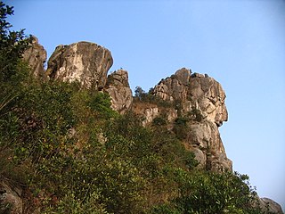
Lion Rock, or less formally Lion Rock Hill, is a mountain in Hong Kong. It is located between Kowloon Tong of Kowloon and Tai Wai of the New Territories, and is 495 metres high. The peak consists of granite covered sparsely by shrubs.

Tai Tam or Tytam is an area in Southern District on Hong Kong Island, Hong Kong. Tai Tam means a big pool in the Chinese language which illustrates a triangular bay, namely Tai Tam Bay between Stanley Peninsula, D'Aguilar Peak and Tai Tam Tuk. The meaning of Tai Tam varies greatly between the early colonial days and the present day.

Tuen Mun or Castle Peak is a city near the mouth of Tuen Mun River and Castle Peak Bay in the New Territories, Hong Kong. It was one of the earliest settlements in what is now Hong Kong and can be dated to the Neolithic period. In the more recent past, it was home to many Tanka fishermen who gathered at Castle Peak Bay. Tuen Mun is now a modern, mainly residential area in the north-west New Territories. As of 2011, 487 546 live in Tuen Mun and over 95% of them are Chinese.

Lantau Peak or Fung Wong Shan is the second highest peak in Hong Kong and the highest point on Lantau Island, with a height of 934 metres (3,064 ft) above sea level. It is most famous for the sunrise scenery viewed from the summit.
Tai Po Road is the second longest road in Hong Kong. It spans from Sham Shui Po in Kowloon to Tai Po in the New Territories of Hong Kong. Initially, the road was named Frontier Road.

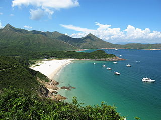
Sharp Peak, also known as Nam She Tsim (蚺蛇尖), is a hill which lies within the Sai Kung East Country Park, north of Tai Long Wan, in the Sai Kung Peninsula in Hong Kong. It is particularly well known for its well defined sharp peak, which rises to a height of 468 metres (1,535 ft) above sea level. The hill is reasonably hard for hikers and should only be attempted in good weather with correct equipment, although it is a popular site for hiking in Hong Kong.

Violet Hill, also known as Tsz Lo Lan Shan is located within Tai Tam Country Park in Hong Kong. The hill is a popular site for hiking. Hong Kong Government named three trails on the hill, namely Wilson Trail, Tsz Lo Lan Shan Path and Tai Tam Country Trail. Towards the top of the hill, it splits into three peaks of altitude 436 m (1,430 ft), 433 m (1,421 ft) and 430 m (1,410 ft). It offers beautiful views of Tai Tam Reservoir Group and Wong Nai Chung Reservoir. The hill is well preserved, with little construction on the hill. A rare and protected species, Hong Kong iris with violet flower can be found on the hill.

Tai Ping Shan Street is a street marking the early colonial history in Hong Kong. Located at the north slope of Victoria Peak in Sheung Wan, the street starts east from a ladder street at the junction with Bridges Street and end west in Po Yan Street near Tung Wah Hospital. The street runs parallel to Hollywood Road.
Tai Mo Shan is the highest peak in Hong Kong, with an elevation of 957 m. It is also the tallest coastal peak in Southern China and second tallest coastal peak in China after Mount Lao, and located at approximately the geographical centre of the New Territories.