
The Hong Kong Special Administrative Region (HKSAR), can be divided into three geographical regions: Hong Kong Island, Kowloon, and the New Territories. Hong Kong is a coastal city and major port in Southern China, bordering Guangdong Province through the city of Shenzhen to the north and the South China Sea to the east, south, and west. Hong Kong and its 260 nearby islands and peninsulas are located at the mouth of the Pearl River Delta. The area of Hong Kong is distinct from Mainland China, but is considered a part of "Greater China".

Lantau Island is the largest island in Hong Kong, located west of Hong Kong Island and the Kowloon Peninsula, and is part of the New Territories. Administratively, most of Lantau Island is part of the Islands District of Hong Kong. A small northeastern portion of the island is located in the Tsuen Wan District.

Tung Chung, meaning "eastern stream", is an area on the northwestern coast of Lantau Island, Hong Kong. One of the most recent new towns, it was formerly a rural fishing village beside Tung Chung Bay, and along the delta and lower courses of Tung Chung River and Ma Wan Chung in the north-western coast of Lantau Island. The area was once an important defence stronghold against pirates and foreign military during the Ming and the Qing dynasties.

Tai O is a fishing town, partly located on an island of the same name, on the western side of Lantau Island in Hong Kong. The village name means large inlet, referring to outlet for the waterways merges as it moves through Tai O.

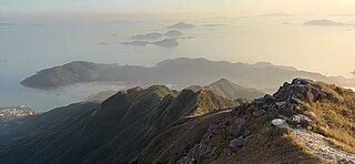
Lantau Peak or Fung Wong Shan is a mountain in Lantau South Country Park, Lantau Island, Hong Kong. It is the second highest peak in Hong Kong and the highest point on Lantau Island, with a height of 934 metres (3,064 ft) above the Hong Kong Principal Datum, or around 933 metres (3,061 ft) above mean sea level.

Sunset Peak or Tai Tung Shan is the third-highest peak in Hong Kong and the second-highest on the island of Lantau. It is situated within the Lantau South Country Park and the Lantau North Country Park and stands at a height of 869 metres (2,851 ft) above the Hong Kong Principal Datum, or 868 metres (2,848 ft) above mean sea level. The second-highest of the territory and the highest on the island, the Lantau Peak, is located to its west.

Yi Tung Shan is the ninth highest mountain in Hong Kong. It is situated east of Sunset Peak on Lantau Island, and is 747 m in height. Stage 2 of The Lantau Trail runs along the north side of its peak.

Shek Pik Reservoir is a reservoir in Shek Pik on Lantau Island in Hong Kong. Built between 1957 and 1963, it has a storage capacity of 24 million cubic metres and is the third largest reservoir in Hong Kong after High Island Reservoir and Plover Cove Reservoir.
A Site of Special Scientific Interest or SSSI is a special area to protect wildlife, habitats and geographic features based on scientific interest in Hong Kong. Scientific interests are special features relating to animal life, plant life, geology and/or geography. After being identified by the Agriculture, Fisheries and Conservation Department, these areas are documented by the Planning Department and added to maps. From 1975 to 2005, 67 locations were designated SSSIs throughout Hong Kong.

High West or Sai Ko Shan, is a mountain on Hong Kong Island with a height of 494 m (1,621 ft)

Lantau North Country Park is one of two rural parks on Lantau Island, Hong Kong and is located on the north side of the island. The 22-square-kilometre (8.5 sq mi) park was designated in 1978.
Articles related to Hong Kong include:

Tai Mo Shan (Chinese: 大帽山; pinyin: Dà mào shān is the highest peak in Hong Kong, with an elevation of 957 metres above the Hong Kong Principal Datum, or around 956 metres above mean sea level. It is located at approximately the geographical centre of the New Territories.
Miu Ko Toi is a peak in Hong Kong. It is situated in New Territories and stands at a height of 779 metres (2,556 ft) above the sea level. It is one of the subpeaks of the tallest mountain Tai Mo Shan and the fifth highest summit in Hong Kong.
Cheung Shan, is a mountain on Lantau Island in Hong Kong at 449 metres (1,473 ft) in height. It is one of the Four Guardian Beasts (四靈獸) of Tai O Village.
Kau Nga Ling, is a series of precipitous mountains on Lantau Island, Hong Kong, with a height of 539 metres (1,768 ft) above sea level. It is one of 16 "high-risk" hiking locations identified by the local government. Kau Nga Ling is inside Lantau South Country Park, which was created in 1978.
Keung Shan is a peak in Hong Kong, on southwestern Lantau Island, with a height of 459 metres (1,506 ft) above sea level.

