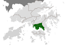
Kowloon Peninsula 九龍半島 | |
---|---|
Coordinates: 22°19′N114°11′E / 22.31°N 114.18°E | |
Time zone | UTC+8 (Hong Kong Time) |
Kowloon Peninsula | |||||||||||||
---|---|---|---|---|---|---|---|---|---|---|---|---|---|
Traditional Chinese | 九龍半島 | ||||||||||||
Simplified Chinese | 九龙半岛 | ||||||||||||
|
The Kowloon Peninsula is a peninsula that forms the southern part of the main landmass in the territory of Hong Kong,alongside Victoria Harbour and facing toward Hong Kong Island. The Kowloon Peninsula and the area of New Kowloon are collectively known as Kowloon.
Geographically,the term "Kowloon Peninsula" may also refer to the area south of the mountain ranges of Beacon Hill,Lion Rock,Tate's Cairn,Kowloon Peak,etc. The peninsula covers five of the eighteen districts of Hong Kong. Kowloon Bay is located at the northeast of the peninsula.
The main rock type of the peninsula consists of a medium grained monzogranite with some fine granite outcrops,part of the Kowloon Granite. [1] [2] Early maps and photographs show flat,low-lying land behind the beach of Tsim Sha Tsui Bay with a raised area,Kowloon Hill,in the west. [3]
The peninsula has been significantly expanded through land reclamation from the sea,over several phases. In the south and west most of the reclamation was carried out before 1904. Reclamation in several other small areas along the main Tsim Sha Tsui waterfront was completed by 1982. Since 1994,parts of the Hung Hom Bay were reclaimed and by 2019,it had been completely extinguished. The West Kowloon Reclamation was formed as part of the Airport Core Programme and largely completed by 1995. [3]
Before the actual Kowloon boundaries were established,the Kowloon Peninsula served as one of the first destinations for escape during China's dynastic times. In 1287,the last emperor of the Song dynasty,Emperor Bing was fleeing from the Mongol leader Kublai Khan. Taking refuge in a cave in the Kowloon peninsula,the inscription wrote "Sung Wong Toi" or "Song Emperor's Pavilion". [4] In the 17th century,after the fall of the Ming dynasty,many of the Emperor's followers also found shelter in the Kowloon peninsula to hide from the Manchus. [4]
Historically speaking,Kowloon Peninsula refers to the ceded territories of Kowloon in 1860 as part of the Convention of Peking,but geographically it covers the entire Kowloon south of the mountain ranges of Lion Rock,Kowloon Peak and other hills. Kowloon Peninsula had a population of 800 when it was ceded to the British Empire in 1860. [5]
In 1898 a resolution was passed by the Colonial Hong Kong Legislative Council to preserve the land where some of the caves stand. [6]
Hong Kong Island is an island in the southern part of Hong Kong. The island,known originally and on road signs simply as "Hong Kong",had a population of 1,289,500 and a population density of 16,390 per square kilometre (42,400/sq mi),as of 2023. It is the second largest island in Hong Kong,with the largest being Lantau Island. Hong Kong Island forms one of the three areas of Hong Kong,with the other two being Kowloon and the New Territories.
Kowloon is an urban area in Hong Kong comprising the Kowloon Peninsula and New Kowloon. It has a population of 2,019,533 and a population density of 43,033/km2 (111,450/sq mi) in 2006. It is one of the three areas of Hong Kong,along with Hong Kong Island and the New Territories. It is the smallest,second most populous and most densely populated of the divisions.
Yau Tsim Mong District is one of 18 districts of Hong Kong,located on the western part of Kowloon Peninsula. It is the core urban area of Kowloon. The district has the second highest population density of all districts,at 49,115 km2 (18,963 sq mi). The 2016 By-Census recorded the total population of Yau Tsim Mong District at 342,970.
Yau Ma Tei is an area in the Yau Tsim Mong District in the south of the Kowloon Peninsula in Hong Kong.
Victoria Harbour is a natural landform harbour in Hong Kong separating Hong Kong Island in the south from the Kowloon Peninsula to the north. The harbour's deep,sheltered waters and strategic location on South China Sea were instrumental in Hong Kong's establishment as a British colony in 1841 and its subsequent development as a trading centre.
Tsim Sha Tsui,often abbreviated as TST,is an area in southern Kowloon,Hong Kong. The area is administratively part of the Yau Tsim Mong District. Tsim Sha Tsui East is a piece of land reclaimed from the Hung Hom Bay now east of Tsim Sha Tsui. The area is bounded north by Austin Road and in the east by Hong Chong Road and Cheong Wan Road.
Jordan is an area in Hong Kong,located on Kowloon Peninsula. It is named after a road of the same name in the district. The area is bordered by King's Park to the east,Tsim Sha Tsui to the south,Ferry Point to the west,and Yau Ma Tei to the north. Administratively,it is part of Yau Tsim Mong District.
Boundary Street is a three-lane one-way street in Kowloon,Hong Kong. It runs in an easterly direction from its start at the intersection with Tung Chau Street in the west,and ends at its intersection with Prince Edward Road West in the east,near the former Kai Tak Airport.
East Tsim Sha Tsui is a station of the Mass Transit Railway (MTR) system of Hong Kong. It is currently an intermediate station on the Tuen Ma line.
Nathan Road is the main thoroughfare in Kowloon,Hong Kong,aligned south–north from Tsim Sha Tsui to Sham Shui Po. It is lined with shops and restaurants and throngs with visitors,and was known in the post–World War II years as the Golden Mile,a name that is now rarely used. It starts on the southern part of Kowloon at its junction with Salisbury Road,a few metres north of Victoria Harbour,and ends at its intersection with Boundary Street in the north. Portions of the Kwun Tong and Tsuen Wan lines run underneath Nathan Road. The total length of Nathan Road is about 3.6 km (2.2 mi).
Kowloon station,colliquially Old Tsim Sha Tsui Terminal,located in Tsim Sha Tsui on the present site of the Hong Kong Cultural Centre,was the former southern terminus of the Kowloon–Canton Railway (KCR).
Blackhead Point,also known as Tai Pau Mai indigenously,or by the names Tsim Sha Tsui Point and Signal Hill (訊號山),was a cape before any land reclamation took place in Tsim Sha Tsui,Kowloon,Hong Kong. It currently remains a small hill near the coast.
Kwun Chung,or Koon Chung in early documents,is an area of Hong Kong,Yau Ma Tei or Tsim Sha Tsui located in the Yau Tsim Mong District.
Middle Road is a street in the southern part of Tsim Sha Tsui,Kowloon,Hong Kong.
East Kowloon line was one of the original five MTR lines proposed in the late 1970s in Hong Kong,which would have connected Sheung Wan with East Kowloon.
Canton Road is a major road in Hong Kong,linking the former west reclamation shore in Tsim Sha Tsui,Jordan,Yau Ma Tei,Mong Kok and Prince Edward on the Kowloon Peninsula. The road runs mostly parallel and west to Nathan Road. It starts from the junction with Salisbury Road in the south and ends in the north at the junction with Lai Chi Kok Road in the Prince Edward area. The southern section of Canton Road is home to many upscale retail shops,shopping centres and others business establishments,with busy traffic from both vehicles and pedestrians from morning till late at night.
Hung Hom Bay was a bay in Victoria Harbour,between Tsim Sha Tsui and Hung Hom in the southeast of Kowloon Peninsula,Hong Kong.
Star Ferry Pier,Tsim Sha Tsui,or Tsim Sha Tsui Ferry Pier,is a pier located on reclaimed land at the southernmost tip of Tsim Sha Tsui on Kowloon Peninsula in Hong Kong. It is commonly known as Star Ferry Pier (天星碼頭) in Tsim Sha Tsui. Star Ferry operates the pedestrian ferry service across Victoria Harbour to Wan Chai and to Central on Hong Kong Island. The location is identified as "Kowloon Point" in the franchise held by Star Ferry.
Kowloon is an urban area that is part of Hong Kong.